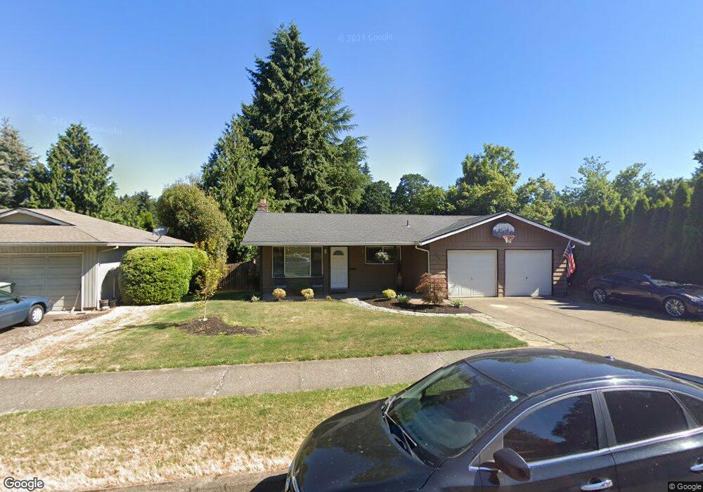
9081 SW Blake St Tualatin, OR 97062
Estimated Value: $479,000 - $552,000
3
Beds
2
Baths
1,308
Sq Ft
$398/Sq Ft
Est. Value
About This Home
This home is located at 9081 SW Blake St, Tualatin, OR 97062 and is currently estimated at $520,688, approximately $398 per square foot. 9081 SW Blake St is a home located in Washington County with nearby schools including Byrom Elementary School, Hazelbrook Middle School, and Tualatin High School.
Ownership History
Date
Name
Owned For
Owner Type
Purchase Details
Closed on
Apr 2, 2012
Sold by
Carr Peter J and Carr Amanda Dawn
Bought by
Carr Peter J
Current Estimated Value
Home Financials for this Owner
Home Financials are based on the most recent Mortgage that was taken out on this home.
Original Mortgage
$156,400
Interest Rate
3.91%
Mortgage Type
New Conventional
Purchase Details
Closed on
Sep 29, 2003
Sold by
Carr Peter J
Bought by
Carr Peter J and Carr Amanda Dawn
Create a Home Valuation Report for This Property
The Home Valuation Report is an in-depth analysis detailing your home's value as well as a comparison with similar homes in the area
Home Values in the Area
Average Home Value in this Area
Purchase History
| Date | Buyer | Sale Price | Title Company |
|---|---|---|---|
| Carr Peter J | -- | Fidelity Natl Title Co Of Or | |
| Carr Peter J | -- | Fidelity Natl Title Co Of Or |
Source: Public Records
Mortgage History
| Date | Status | Borrower | Loan Amount |
|---|---|---|---|
| Closed | Carr Peter J | $156,400 |
Source: Public Records
Tax History Compared to Growth
Tax History
| Year | Tax Paid | Tax Assessment Tax Assessment Total Assessment is a certain percentage of the fair market value that is determined by local assessors to be the total taxable value of land and additions on the property. | Land | Improvement |
|---|---|---|---|---|
| 2025 | $4,095 | $240,760 | -- | -- |
| 2024 | $3,988 | $233,750 | -- | -- |
| 2023 | $3,988 | $226,950 | $0 | $0 |
| 2022 | $3,815 | $226,950 | $0 | $0 |
| 2021 | $3,722 | $213,930 | $0 | $0 |
| 2020 | $3,612 | $207,700 | $0 | $0 |
| 2019 | $3,515 | $201,660 | $0 | $0 |
| 2018 | $3,372 | $195,790 | $0 | $0 |
| 2017 | $3,175 | $190,090 | $0 | $0 |
| 2016 | $3,028 | $184,560 | $0 | $0 |
| 2015 | $2,905 | $179,190 | $0 | $0 |
| 2014 | $2,823 | $173,980 | $0 | $0 |
Source: Public Records
Map
Nearby Homes
- 9433 SW Siuslaw Ln
- 21150 SW Arapaho Ct
- 20916 SW Siletz Ct
- 8904 Salinan St
- 8829 Salinan St
- 8821 SW Salinan St
- 8811 SW Salinan St
- 8836 Salinan St
- 9495 SW Cherry Ln
- 20685 SW Siletz Ct
- 21932 SW Creek Dr
- 8501 SW Iroquois Dr
- 22040 SW Grahams Ferry Rd Unit B
- 22030 SW Grahams Ferry Rd Unit D
- 22000 SW Grahams Ferry Rd Unit C
- 21689 SW Klickitat Ct
- 8715 SW Tachi Ct
- 8263 SW Blake St
- 9995 SW Siuslaw Ln
- 20900 SW Winema Dr
- 9055 SW Blake St
- 9107 SW Blake St
- 21401 SW 91st Ct
- 21408 SW 92nd Ave
- 9029 SW Blake St
- 21383 SW 91st Ct
- 21430 SW 92nd Ave
- 9126 SW Blake St
- 21382 SW 92nd Ave
- 9150 SW Blake St
- 21485 SW 91st Ave
- 21404 SW 91st Ct
- 9186 SW Blake St
- 9003 SW Blake St
- 21361 SW 91st Ct
- 21360 SW 92nd Ave
- 21521 SW 91st Ave
- 21388 SW 91st Ct
- 21448 SW Cayuse Ct
- 21488 SW 91st Ave