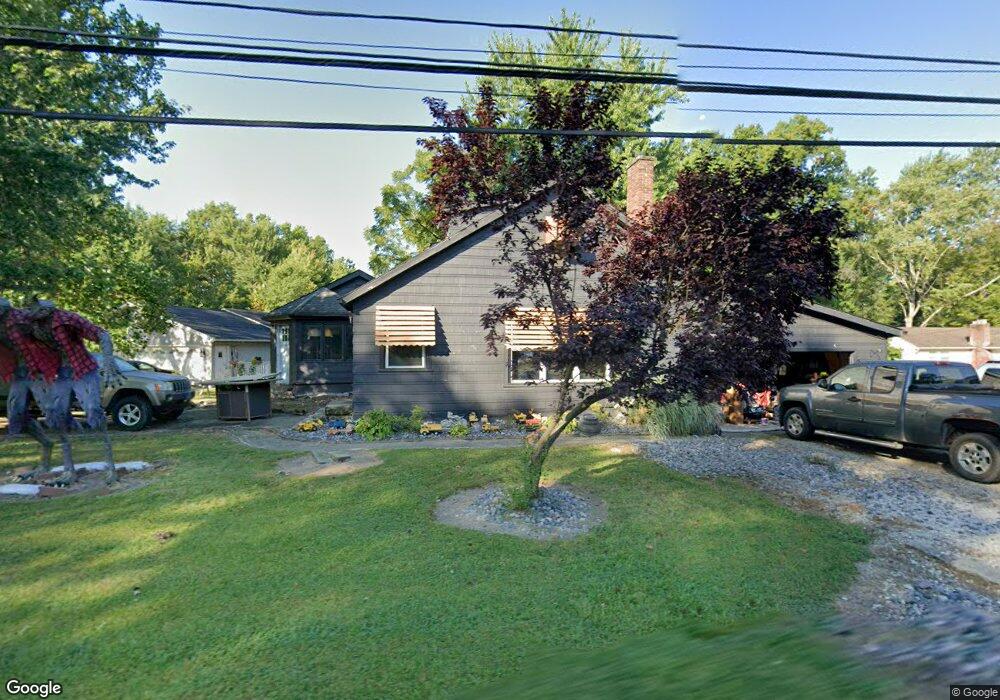
9084 Fair Rd Strongsville, OH 44149
Estimated Value: $258,398 - $359,000
3
Beds
2
Baths
1,602
Sq Ft
$186/Sq Ft
Est. Value
About This Home
This home is located at 9084 Fair Rd, Strongsville, OH 44149 and is currently estimated at $297,350, approximately $185 per square foot. 9084 Fair Rd is a home located in Cuyahoga County with nearby schools including Strongsville High School, Sts Joseph & John Interparochial School, and St Mary School.
Ownership History
Date
Name
Owned For
Owner Type
Purchase Details
Closed on
May 15, 2017
Sold by
Turski Nora J
Bought by
Turski Matthew F
Current Estimated Value
Purchase Details
Closed on
Feb 21, 2017
Sold by
Hyldahl Mark
Bought by
Turski Matthew F and Turski Nora J
Home Financials for this Owner
Home Financials are based on the most recent Mortgage that was taken out on this home.
Original Mortgage
$85,500
Outstanding Balance
$70,631
Interest Rate
4.12%
Mortgage Type
Purchase Money Mortgage
Estimated Equity
$226,719
Purchase Details
Closed on
Oct 19, 2011
Sold by
Secretary Of Housing & Urban Development
Bought by
Hyldahl Mark
Purchase Details
Closed on
Feb 3, 2011
Sold by
Conlan Thomas P and Haynes Rebecca
Bought by
Citmortgage Inc
Purchase Details
Closed on
Dec 27, 2010
Sold by
Citimortgage Inc
Bought by
Secretary Of Housing & Urban Development
Purchase Details
Closed on
Jan 24, 2007
Sold by
Va
Bought by
Conlan Thomas and Haynes Rebecca
Home Financials for this Owner
Home Financials are based on the most recent Mortgage that was taken out on this home.
Original Mortgage
$117,077
Interest Rate
6.19%
Mortgage Type
FHA
Purchase Details
Closed on
Oct 6, 2005
Sold by
Melvin Yolanda X and Melvin Ronald C
Bought by
Va
Purchase Details
Closed on
Oct 26, 2000
Sold by
Melvin Ronald C
Bought by
Melvin Yolanda X
Purchase Details
Closed on
Feb 29, 2000
Sold by
Klypchak Charles A
Bought by
Melvin Ronald C and Melvin Yolanda X
Home Financials for this Owner
Home Financials are based on the most recent Mortgage that was taken out on this home.
Original Mortgage
$127,500
Interest Rate
8.21%
Mortgage Type
VA
Purchase Details
Closed on
Oct 28, 1985
Sold by
Slaby Ii Charles Edward
Bought by
Klypchak Charles A
Purchase Details
Closed on
May 31, 1984
Sold by
Slaby Charles E
Bought by
Slaby Ii Charles Edward
Purchase Details
Closed on
Apr 29, 1980
Sold by
Paul John and Paul Emily
Bought by
Slaby Charles E
Purchase Details
Closed on
Jan 1, 1975
Bought by
Paul John and Paul Emily
Create a Home Valuation Report for This Property
The Home Valuation Report is an in-depth analysis detailing your home's value as well as a comparison with similar homes in the area
Home Values in the Area
Average Home Value in this Area
Purchase History
| Date | Buyer | Sale Price | Title Company |
|---|---|---|---|
| Turski Matthew F | -- | None Available | |
| Turski Matthew F | $95,000 | None Available | |
| Hyldahl Mark | $42,894 | Lakeside Title | |
| Citmortgage Inc | $83,334 | None Available | |
| Secretary Of Housing & Urban Development | -- | None Available | |
| Conlan Thomas | -- | Maximum Title | |
| Va | $105,000 | Attorney | |
| Melvin Yolanda X | -- | -- | |
| Melvin Ronald C | $125,000 | Executive Title Agency Inc | |
| Klypchak Charles A | $55,000 | -- | |
| Slaby Ii Charles Edward | -- | -- | |
| Slaby Charles E | $55,000 | -- | |
| Paul John | -- | -- |
Source: Public Records
Mortgage History
| Date | Status | Borrower | Loan Amount |
|---|---|---|---|
| Open | Turski Matthew F | $85,500 | |
| Previous Owner | Conlan Thomas | $117,077 | |
| Previous Owner | Melvin Ronald C | $127,500 |
Source: Public Records
Tax History Compared to Growth
Tax History
| Year | Tax Paid | Tax Assessment Tax Assessment Total Assessment is a certain percentage of the fair market value that is determined by local assessors to be the total taxable value of land and additions on the property. | Land | Improvement |
|---|---|---|---|---|
| 2024 | $3,369 | $71,750 | $14,630 | $57,120 |
| 2023 | $3,868 | $61,780 | $19,080 | $42,700 |
| 2022 | $3,840 | $61,780 | $19,080 | $42,700 |
| 2021 | $3,810 | $61,780 | $19,080 | $42,700 |
| 2020 | $3,531 | $50,650 | $15,650 | $35,000 |
| 2019 | $3,427 | $144,700 | $44,700 | $100,000 |
| 2018 | $3,023 | $50,650 | $15,650 | $35,000 |
| 2017 | $2,991 | $45,080 | $12,390 | $32,690 |
| 2016 | $2,966 | $45,080 | $12,390 | $32,690 |
| 2015 | $6,407 | $45,080 | $12,390 | $32,690 |
| 2014 | $6,407 | $43,750 | $12,040 | $31,710 |
Source: Public Records
Map
Nearby Homes
- 9401 Pheasant Run Place
- 8627 Courtland Dr
- 84 Sprague Rd
- 20424 Scotch Pine Way
- 8036 Fair Rd
- 21176 Hickory Branch Trail
- 10353 Oak Branch Trail
- 104 Whitehall Dr
- 21355 Hickory Branch Trail
- 8902 Lincolnshire Blvd
- 9829 Plum Brook Ln
- 10839 Prospect Rd
- 740 Fair St
- 20684 Albion Rd
- 0 Priem Rd
- 22300 Rock Creek Cir
- 243 Jananna Dr
- 9598 Pebble Brook Ln
- 148 Meadow Cir
- 19890 Idlewood Trail