
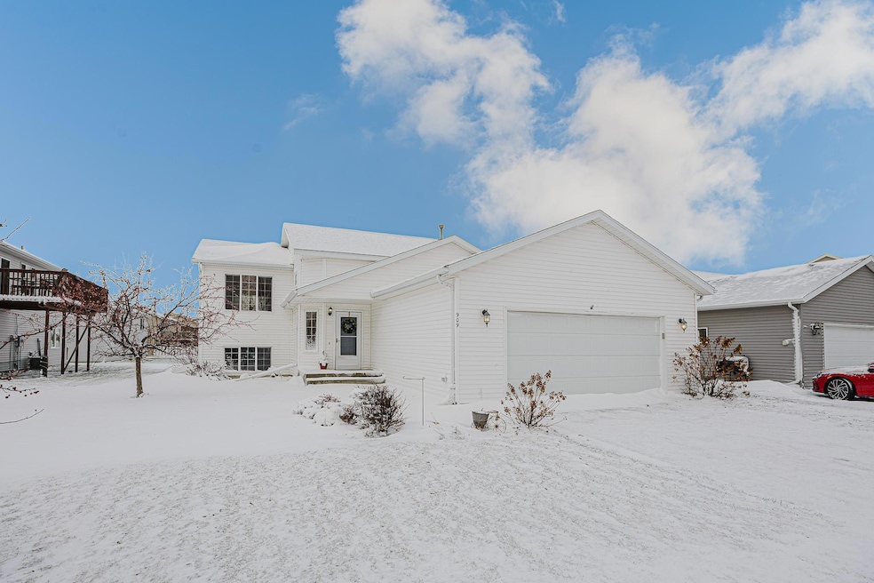
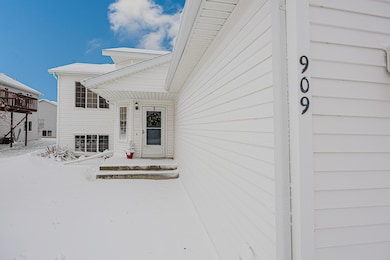

909 38 1 2 Ave W West Fargo, ND 58078
Eagle Run NeighborhoodEstimated payment $1,947/month
4
Beds
2
Baths
1,928
Sq Ft
$161
Price per Sq Ft
Highlights
- No HOA
- Living Room
- Forced Air Heating and Cooling System
- 2 Car Attached Garage
- Laundry Room
- Dining Room
About This Home
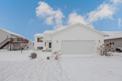
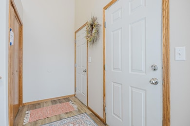
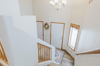
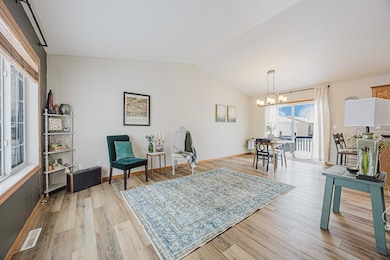
Great house in Eagle Run area of West Fargo, complete with four bedrooms, two bathrooms, wonderful lower level living room with garden level windows. Amazing house with great layout, entire interior was freshly renovated! Updates include new flooring, new carpets everywhere, new backsplash tile, new vanity in primary. Many interior updates made for you already, including new main level bathroom, updates in lower level bathroom, updates made in kitchen, new light fixtures, great yard, washer and dryer included....the list just keeps going!!! Property is situated near corner and neighboring lot is turned so the yard offers an open green spaces to side. This home features a 2 stall garage with great driveway and extra space inside of garage for storage around vehicles, in attic and work bench. Enjoy the large walk out deck and patio space in the back yard. Great closets and storage in both the utility room as well as under the stairs for all of your holiday items. All of the remodeling and updates have already been done for you now, so it is move in ready! Deck stain included with sale...just could not get it done before temps dipped. All lending types with qualify on this amazing property, property is Agent Owned. Schedule a showing today as it will not last.
Listing Agent
eXp Realty (3788 FGO) Brokerage Phone: 701-354-2725 Listed on: 11/26/2025
Home Details
Home Type
- Single Family
Est. Annual Taxes
- $3,764
Year Built
- Built in 2003
Lot Details
- 7,754 Sq Ft Lot
- Lot Dimensions are 60 x 125
Parking
- 2 Car Attached Garage
Home Design
- Bi-Level Home
- Vinyl Siding
Interior Spaces
- Family Room
- Living Room
- Dining Room
- Laundry Room
- Basement
Bedrooms and Bathrooms
- 4 Bedrooms
- 2 Full Bathrooms
Utilities
- Forced Air Heating and Cooling System
Community Details
- No Home Owners Association
- Eagle Run 6Th Add Subdivision
Listing and Financial Details
- Assessor Parcel Number 02018500590000
Map
Create a Home Valuation Report for This Property
The Home Valuation Report is an in-depth analysis detailing your home's value as well as a comparison with similar homes in the area
Home Values in the Area
Average Home Value in this Area
Tax History
| Year | Tax Paid | Tax Assessment Tax Assessment Total Assessment is a certain percentage of the fair market value that is determined by local assessors to be the total taxable value of land and additions on the property. | Land | Improvement |
|---|---|---|---|---|
| 2024 | $3,764 | $143,500 | $22,500 | $121,000 |
| 2023 | $4,132 | $138,200 | $22,500 | $115,700 |
| 2022 | $3,880 | $127,000 | $22,500 | $104,500 |
| 2021 | $3,658 | $118,600 | $18,000 | $100,600 |
| 2020 | $3,444 | $112,850 | $18,000 | $94,850 |
| 2019 | $3,436 | $109,100 | $18,000 | $91,100 |
| 2018 | $3,426 | $110,650 | $18,000 | $92,650 |
| 2017 | $4,309 | $110,650 | $18,000 | $92,650 |
| 2016 | $4,144 | $108,450 | $18,000 | $90,450 |
| 2015 | $3,943 | $88,550 | $9,450 | $79,100 |
| 2014 | $3,973 | $82,750 | $9,450 | $73,300 |
| 2013 | $3,921 | $78,600 | $9,450 | $69,150 |
Source: Public Records
Property History
| Date | Event | Price | List to Sale | Price per Sq Ft |
|---|---|---|---|---|
| 11/26/2025 11/26/25 | For Sale | $310,000 | -- | $161 / Sq Ft |
Source: NorthstarMLS
Purchase History
| Date | Type | Sale Price | Title Company |
|---|---|---|---|
| Warranty Deed | $224,500 | Fm Title |
Source: Public Records
Mortgage History
| Date | Status | Loan Amount | Loan Type |
|---|---|---|---|
| Open | $179,600 | New Conventional |
Source: Public Records
About the Listing Agent
The founder of the Brandenburg Crew Inc., Derek, was raised with the notion that hard work was a way of life. Growing up on a farm, most days started at 6am, and ended at 11pm. This work ethic followed him into his military career, where he understood the importance of a strong value system. After 7 years of service, Derek took on a new challenge, branching into real estate. He built a team with the prerequisite of believing in the same core values, dedication, commitment, discipline and most
Derek's Other Listings
Source: NorthstarMLS
MLS Number: 6822129
APN: 02-0185-00590-000
Disclaimer: Certain information contained herein is derived from information provided by parties other than Homes.com. All information provided is deemed reliable, but is not guaranteed to be accurate and should be independently verified.
![]() Based on information submitted to the MLS GRID. All data is obtained from various sources and may not have been verified by broker or MLS GRID. Supplied Open House Information is subject to change without notice. All information should be independently reviewed and verified for accuracy. Properties may or may not be listed by the office/agent presenting the information. Some IDX listings have been excluded from this website.
Based on information submitted to the MLS GRID. All data is obtained from various sources and may not have been verified by broker or MLS GRID. Supplied Open House Information is subject to change without notice. All information should be independently reviewed and verified for accuracy. Properties may or may not be listed by the office/agent presenting the information. Some IDX listings have been excluded from this website.
The Digital Millennium Copyright Act of 1998, 17 U.S.C. § 512 (the “DMCA”) provides recourse for copyright owners who believe that material appearing on the Internet infringes their rights under U.S. copyright law. If you believe in good faith that any content or material made available in connection with our website or services infringes your copyright, you (or your agent) may send us a notice requesting that the content or material be removed, or access to it blocked.
Notices must be sent in writing by email to DMCAnotice@MLSGrid.com.
The DMCA requires that your notice of alleged copyright infringement include the following information:
(1) description of the copyrighted work that is the subject of claimed infringement;
(2) description of the alleged infringing content and information sufficient to permit us to locate the content;
(3) contact information for you, including your address, telephone number and email address;
(4) a statement by you that you have a good faith belief that the content in the manner complained of is not authorized by the copyright owner, or its agent, or by the operation of any law;
(5) a statement by you, signed under penalty of perjury, that the information in the notification is accurate and that you have the authority to enforce the copyrights that are claimed to be infringed; and
(6) a physical or electronic signature of the copyright owner or a person authorized to act on the copyright owner’s behalf. Failure to include all of the above information may result in the delay of the processing of your complaint.
Nearby Homes
- 828 Cinnamon Ridge Place
- 1040 39th Ave W
- 1054 42nd Ave W
- 1051 38 1 2 Ave W
- 1051 42nd Ave W
- 1060 Parkway Ln
- 537 S Sedona Dr
- 1156 42nd Ave W Unit A
- 3662 N Sedona Ct
- 1168 43rd Ave W
- 3834 12th St W
- 1236 S Beach Way
- 1381 Westport Beach Way
- 4507 Newport Ln
- 4509 11th St W
- 3561 Eagle Run Ln
- 4717 11th St W
- 4757 11th St W
- 1089 Hickory Ln
- 1082 Larkin Ln
- 3412 5th St W
- 3435 5th St W
- 639 33rd Ave W
- 3252 6th St W
- 360 32nd Ave W
- 3150 Sheyenne St
- 320 32nd Ave
- 2920 Sheyenne St
- 2824 5th St W
- 401 26th Ave W
- 5476 Lori Ln W
- 862 36th Ave E
- 855 E 34th Ave
- 5652 36th Ave S
- 5671 34th Ave S
- 3900 S 56th St
- 5601 34th Ave S
- 5599 36th Ave S
- 1001 60th Ave W
- 745 31st Ave E