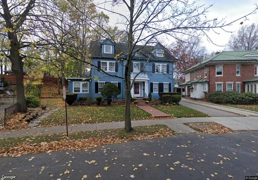
91 Crowninshield Rd Brookline, MA 02446
Coolidge Corner NeighborhoodEstimated Value: $2,812,000 - $3,306,000
5
Beds
4
Baths
3,228
Sq Ft
$931/Sq Ft
Est. Value
About This Home
This home is located at 91 Crowninshield Rd, Brookline, MA 02446 and is currently estimated at $3,005,027, approximately $930 per square foot. 91 Crowninshield Rd is a home located in Norfolk County with nearby schools including Florida Ruffin Ridley, Brookline High School, and Match Charter Public School.
Ownership History
Date
Name
Owned For
Owner Type
Purchase Details
Closed on
Feb 10, 2025
Sold by
Perkins Carol K Est and Kickham
Bought by
Kickham Robert T
Current Estimated Value
Purchase Details
Closed on
Jul 19, 2018
Sold by
Kickham Christopher S
Bought by
Kickham Robert T
Purchase Details
Closed on
Mar 1, 2018
Sold by
Kickham Christopher S
Bought by
Kickham Robert T
Purchase Details
Closed on
Aug 28, 2017
Sold by
Kickham Christopher S
Bought by
Kickham Robert T
Purchase Details
Closed on
Aug 19, 2009
Sold by
Carney Mary K
Bought by
Kickham Robert T
Purchase Details
Closed on
Apr 5, 1999
Sold by
Kickham William D
Bought by
Kickham Robert T and Kickham Timothy C
Purchase Details
Closed on
Feb 13, 1997
Sold by
Kickham John W
Bought by
Kickham Robert T
Create a Home Valuation Report for This Property
The Home Valuation Report is an in-depth analysis detailing your home's value as well as a comparison with similar homes in the area
Home Values in the Area
Average Home Value in this Area
Purchase History
| Date | Buyer | Sale Price | Title Company |
|---|---|---|---|
| Kickham Robert T | -- | None Available | |
| Kickham Robert T | -- | None Available | |
| Kickham Robert T | $50,000 | -- | |
| Kickham Robert T | $50,000 | -- | |
| Kickham Robert T | $50,000 | -- | |
| Kickham Robert T | $50,000 | -- | |
| Kickham Robert T | $50,000 | -- | |
| Kickham Robert T | $50,000 | -- | |
| Kickham Robert T | $79,000 | -- | |
| Kickham Robert T | $79,000 | -- | |
| Kickham Robert T | $61,500 | -- | |
| Kickham Robert T | $45,800 | -- | |
| Kickham Robert T | $45,800 | -- |
Source: Public Records
Tax History
| Year | Tax Paid | Tax Assessment Tax Assessment Total Assessment is a certain percentage of the fair market value that is determined by local assessors to be the total taxable value of land and additions on the property. | Land | Improvement |
|---|---|---|---|---|
| 2025 | $22,369 | $2,266,400 | $1,456,300 | $810,100 |
| 2024 | $21,285 | $2,178,600 | $1,400,200 | $778,400 |
| 2023 | $21,081 | $2,114,400 | $1,295,800 | $818,600 |
| 2022 | $20,520 | $2,013,700 | $1,234,100 | $779,600 |
| 2021 | $18,975 | $1,936,200 | $1,186,600 | $749,600 |
| 2020 | $17,173 | $1,817,300 | $1,078,800 | $738,500 |
| 2019 | $16,217 | $1,730,700 | $1,027,400 | $703,300 |
| 2018 | $14,635 | $1,547,000 | $856,200 | $690,800 |
| 2017 | $14,419 | $1,459,400 | $807,700 | $651,700 |
| 2016 | $14,212 | $1,363,900 | $754,900 | $609,000 |
| 2015 | $13,614 | $1,274,700 | $705,500 | $569,200 |
| 2014 | $12,824 | $1,125,900 | $587,800 | $538,100 |
Source: Public Records
Map
Nearby Homes
- 99 Crowninshield Rd Unit 99
- 157 Babcock St Unit 1
- 125 Crowninshield Rd Unit 125
- 85 Naples Rd
- 85 Naples Rd Unit 1
- 28 Winslow Rd
- 79 Pleasant St Unit 4
- 26 Egmont St Unit C11
- 63-65 Green St Unit 1
- 63-65 Green St Unit PH-3
- 63 Green St Unit 2
- 221 Saint Paul St
- 140 Fuller St Unit 3
- 38 Stedman St Unit 38A
- 26 John St Unit 3
- 21 Green St Unit 3
- 14 Green St Unit PHA
- 14 Green St Unit PH1
- 373 Harvard St Unit 1
- 116 Thorndike St Unit 1
- 15 Craig Place Unit 15
- 15 Craig Place
- 15 Craig Place Unit 1
- 15 Craig Place Unit 4
- 15 Craig Place
- 15 Craig Place
- 95 Crowninshield Rd
- 17 Craig Place Unit 19
- 19 Craig Place Unit 3
- 17 Craig Place Unit 1
- 17-19 Craig Place
- 217 Freeman St
- 217 Freeman St
- 217 Freeman St Unit 905
- 217 Freeman St Unit 2
- 13 Craig Place
- 11 Craig Place
- 13 Craig Place Unit 13
- 13 Craig Place Unit 2
- 99 Crowninshield Rd Unit B4
Your Personal Tour Guide
Ask me questions while you tour the home.