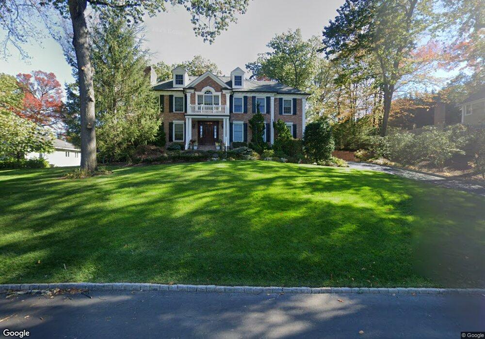
91 Fernwood Rd Summit, NJ 07901
Estimated Value: $3,357,880 - $5,066,000
--
Bed
--
Bath
7,490
Sq Ft
$566/Sq Ft
Est. Value
About This Home
This home is located at 91 Fernwood Rd, Summit, NJ 07901 and is currently estimated at $4,239,627, approximately $566 per square foot. 91 Fernwood Rd is a home located in Union County with nearby schools including L C Johnson Summit Middle School, Summit Sr High School, and Kent Place School.
Ownership History
Date
Name
Owned For
Owner Type
Purchase Details
Closed on
Jun 15, 2009
Sold by
Fernwood Realty Group Llc
Bought by
Lorenz William A and Lorenz Victoria A
Current Estimated Value
Home Financials for this Owner
Home Financials are based on the most recent Mortgage that was taken out on this home.
Original Mortgage
$2,170,000
Outstanding Balance
$879,557
Interest Rate
1.91%
Mortgage Type
Purchase Money Mortgage
Estimated Equity
$3,360,070
Purchase Details
Closed on
Dec 5, 2006
Sold by
Lindner Laurie
Bought by
Fernwood Realty Group Llc
Home Financials for this Owner
Home Financials are based on the most recent Mortgage that was taken out on this home.
Original Mortgage
$1,821,000
Interest Rate
6.16%
Mortgage Type
Construction
Purchase Details
Closed on
May 25, 2005
Sold by
Lindner Malvin
Bought by
Lindner Laurie
Purchase Details
Closed on
Dec 17, 2001
Sold by
Lindner Malvin and Lindner Laurie
Bought by
Lindner Malvin and Lindner Laurie
Create a Home Valuation Report for This Property
The Home Valuation Report is an in-depth analysis detailing your home's value as well as a comparison with similar homes in the area
Home Values in the Area
Average Home Value in this Area
Purchase History
| Date | Buyer | Sale Price | Title Company |
|---|---|---|---|
| Lorenz William A | $3,100,000 | None Available | |
| Fernwood Realty Group Llc | $1,365,000 | -- | |
| Lindner Laurie | -- | -- | |
| Lindner Malvin | -- | -- |
Source: Public Records
Mortgage History
| Date | Status | Borrower | Loan Amount |
|---|---|---|---|
| Open | Lorenz William A | $2,170,000 | |
| Previous Owner | Fernwood Realty Group Llc | $1,821,000 |
Source: Public Records
Tax History Compared to Growth
Tax History
| Year | Tax Paid | Tax Assessment Tax Assessment Total Assessment is a certain percentage of the fair market value that is determined by local assessors to be the total taxable value of land and additions on the property. | Land | Improvement |
|---|---|---|---|---|
| 2025 | $51,148 | $1,174,200 | $219,800 | $954,400 |
| 2024 | $50,808 | $1,174,200 | $219,800 | $954,400 |
| 2023 | $50,808 | $1,174,200 | $219,800 | $954,400 |
| 2022 | $50,291 | $1,174,200 | $219,800 | $954,400 |
| 2021 | $50,690 | $1,174,200 | $219,800 | $954,400 |
| 2020 | $51,195 | $1,174,200 | $219,800 | $954,400 |
| 2019 | $51,254 | $1,174,200 | $219,800 | $954,400 |
| 2018 | $50,925 | $1,174,200 | $219,800 | $954,400 |
| 2017 | $51,254 | $1,174,200 | $219,800 | $954,400 |
| 2016 | $50,502 | $1,174,200 | $219,800 | $954,400 |
| 2015 | $49,516 | $1,174,200 | $219,800 | $954,400 |
| 2014 | $48,236 | $1,174,200 | $219,800 | $954,400 |
Source: Public Records
Map
Nearby Homes