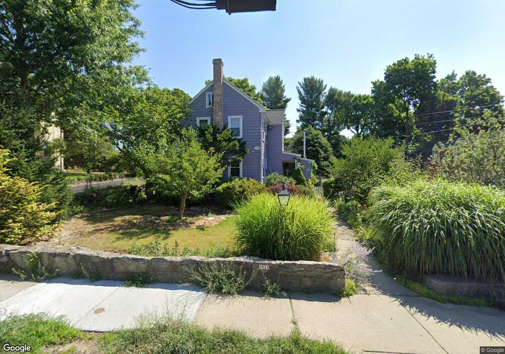
91 High St Newton, MA 02461
Newton Upper Falls NeighborhoodEstimated Value: $1,291,000 - $1,441,000
4
Beds
4
Baths
2,512
Sq Ft
$549/Sq Ft
Est. Value
About This Home
This home is located at 91 High St, Newton, MA 02461 and is currently estimated at $1,379,408, approximately $549 per square foot. 91 High St is a home located in Middlesex County with nearby schools including Angier Elementary School, Zervas Elementary School, and Charles E Brown Middle School.
Ownership History
Date
Name
Owned For
Owner Type
Purchase Details
Closed on
Aug 2, 2021
Sold by
Thompson Deborah A
Bought by
D A Thompson 2021 T
Current Estimated Value
Purchase Details
Closed on
May 3, 1993
Sold by
Bodger Allan J and Bodger Christine S
Bought by
Thompson Deborah A
Home Financials for this Owner
Home Financials are based on the most recent Mortgage that was taken out on this home.
Original Mortgage
$120,000
Interest Rate
7.51%
Mortgage Type
Purchase Money Mortgage
Create a Home Valuation Report for This Property
The Home Valuation Report is an in-depth analysis detailing your home's value as well as a comparison with similar homes in the area
Home Values in the Area
Average Home Value in this Area
Purchase History
| Date | Buyer | Sale Price | Title Company |
|---|---|---|---|
| D A Thompson 2021 T | -- | None Available | |
| Thompson Deborah A | $231,500 | -- |
Source: Public Records
Mortgage History
| Date | Status | Borrower | Loan Amount |
|---|---|---|---|
| Previous Owner | Thompson Deborah A | $120,000 |
Source: Public Records
Tax History
| Year | Tax Paid | Tax Assessment Tax Assessment Total Assessment is a certain percentage of the fair market value that is determined by local assessors to be the total taxable value of land and additions on the property. | Land | Improvement |
|---|---|---|---|---|
| 2025 | $10,012 | $1,021,600 | $773,200 | $248,400 |
| 2024 | $9,680 | $991,800 | $750,700 | $241,100 |
| 2023 | $9,267 | $910,300 | $613,100 | $297,200 |
| 2022 | $8,867 | $842,900 | $567,700 | $275,200 |
| 2021 | $8,321 | $773,300 | $520,800 | $252,500 |
| 2020 | $8,073 | $773,300 | $520,800 | $252,500 |
| 2019 | $7,552 | $722,700 | $486,700 | $236,000 |
| 2018 | $7,393 | $683,300 | $454,500 | $228,800 |
| 2017 | $6,971 | $626,900 | $417,000 | $209,900 |
| 2016 | $6,545 | $575,100 | $382,600 | $192,500 |
| 2015 | $6,240 | $537,500 | $357,600 | $179,900 |
Source: Public Records
Map
Nearby Homes
- 5 Summer St
- 1003 Chestnut St
- 51 Pettee St Unit 31
- 304 Elliot St Carriage House S Unit 4
- 302 Elliot St Carriage House N Unit 3
- 300 Elliot St Unit 2
- 27 Hamilton Place
- 14 Pennsylvania Ave Unit 1
- 20 Pennsylvania Ave
- 20 Pennsylvania Ave Unit 20
- 59 Roundwood Rd
- 66 Linden St
- 1077 Boylston St Unit 1
- 829 Chestnut St
- 18 Josselyn Place Unit 18
- 16-18 Josselyn Place Unit 16
- 12 Bemuth Rd
- 18 Evergreen Rd
- 180 Allen Ave
- 34 Larchmont Ave
- 11 Chilton Place
- 9 Chilton Place
- 9 Chilton Place Unit 11
- 85 High St
- 99 High St
- 17 Chilton Place
- 15 Chilton Place
- 17 Chilton Place Unit 2
- 15 Chilton Place Unit 1
- 17 Chilton Place Unit 17
- 103 High St
- 87 Rockland Place
- 83 High St Unit 83A
- 83 High St
- 86 High St Unit 86
- 86 High St
- 6 Summer St
- 80 High St Unit 82
- 80 High St Unit 80
- 80 High St Unit 1
Your Personal Tour Guide
Ask me questions while you tour the home.