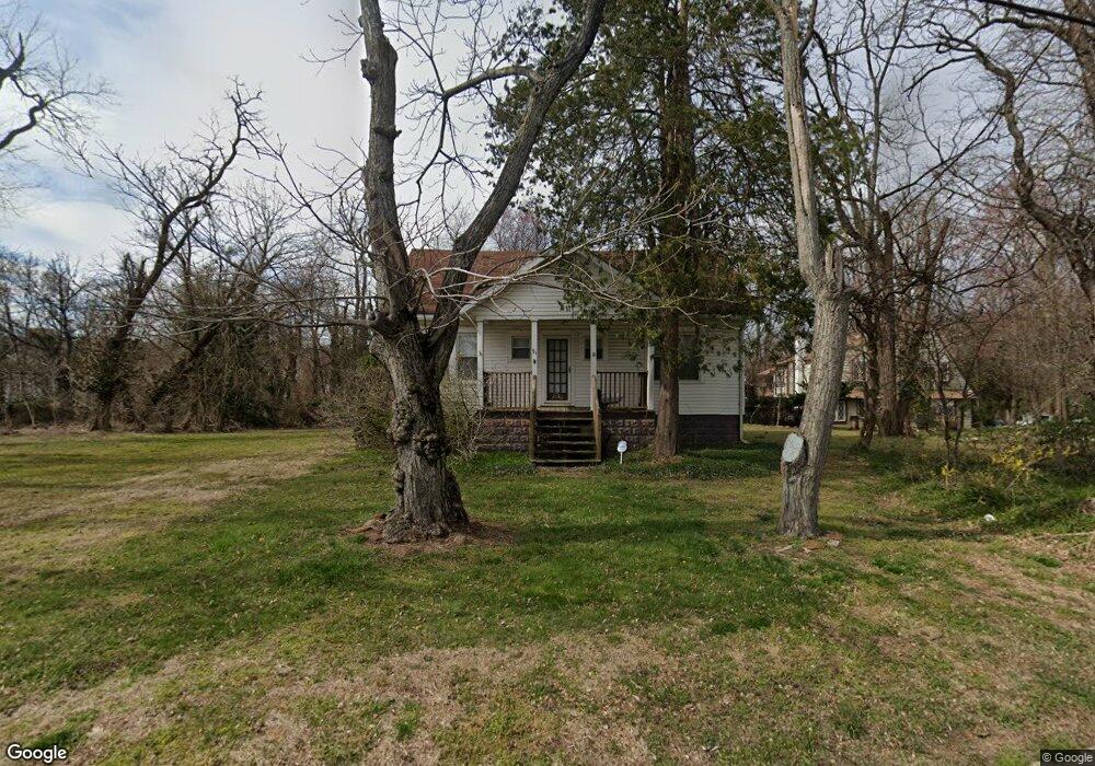
91 Kings Hwy Moorestown, NJ 08057
Estimated Value: $282,516 - $405,000
2
Beds
1
Bath
792
Sq Ft
$449/Sq Ft
Est. Value
About This Home
This home is located at 91 Kings Hwy, Moorestown, NJ 08057 and is currently estimated at $355,879, approximately $449 per square foot. 91 Kings Hwy is a home located in Burlington County with nearby schools including Mary E. Roberts Elementary School, Moorestown Upper Elementary School, and William Allen Middle School.
Ownership History
Date
Name
Owned For
Owner Type
Purchase Details
Closed on
Jun 22, 2017
Sold by
Whitchraft Robert J and Whitchraft Patricia M
Bought by
High Dollar Realty Associates Llc
Current Estimated Value
Purchase Details
Closed on
May 26, 2005
Sold by
Whitcraft Robert J
Bought by
Whitcraft Robert J and Whitcraft Patricia Maureen
Purchase Details
Closed on
Nov 7, 2003
Sold by
Whitcraft Robert J
Bought by
Whitcraft Robert J and Whitcraft Robert J
Purchase Details
Closed on
Jul 28, 1994
Sold by
Peterkin Catherine E
Bought by
Whitcraft Robert J
Create a Home Valuation Report for This Property
The Home Valuation Report is an in-depth analysis detailing your home's value as well as a comparison with similar homes in the area
Home Values in the Area
Average Home Value in this Area
Purchase History
| Date | Buyer | Sale Price | Title Company |
|---|---|---|---|
| High Dollar Realty Associates Llc | $170,000 | Surety Title Co | |
| Whitcraft Robert J | -- | -- | |
| Whitcraft Robert J | -- | -- | |
| Whitcraft Robert J | $85,000 | Settlers Title Agency Lp |
Source: Public Records
Tax History Compared to Growth
Tax History
| Year | Tax Paid | Tax Assessment Tax Assessment Total Assessment is a certain percentage of the fair market value that is determined by local assessors to be the total taxable value of land and additions on the property. | Land | Improvement |
|---|---|---|---|---|
| 2025 | $3,952 | $139,300 | $78,100 | $61,200 |
| 2024 | $3,832 | $139,300 | $78,100 | $61,200 |
| 2023 | $3,832 | $139,300 | $78,100 | $61,200 |
| 2022 | $3,793 | $139,300 | $78,100 | $61,200 |
| 2021 | $3,743 | $139,300 | $78,100 | $61,200 |
| 2020 | $3,719 | $139,300 | $78,100 | $61,200 |
| 2019 | $3,654 | $139,300 | $78,100 | $61,200 |
| 2018 | $3,555 | $139,300 | $78,100 | $61,200 |
| 2017 | $3,586 | $139,300 | $78,100 | $61,200 |
| 2016 | $3,573 | $139,300 | $78,100 | $61,200 |
| 2015 | $3,530 | $139,300 | $78,100 | $61,200 |
| 2014 | $3,352 | $139,300 | $78,100 | $61,200 |
Source: Public Records
Map
Nearby Homes
- 21 Foxwood Dr Unit 21
- 403 S Lenola Rd
- 512 Regenhard Ave
- 112 Beacon St
- 12 Greenvale Rd
- 115 E Kings Hwy Unit 386
- 115 E Kings Hwy Unit 442
- 115 E Kings Hwy Unit 410
- 115 E Kings Hwy Unit 216
- 115 E Kings Hwy Unit 444
- 115 E Kings Hwy Unit 319
- 115 E Kings Hwy Unit 443
- 206 E Camden Ave
- 116 S Lincoln Ave
- 198 S Lincoln Ave
- 801 E Camden Ave
- 602 Windsor Place
- 114 Grant Ave
- 601 Stratford Dr
- 1 Circle Dr
- 531 Reganhardt Ave
- 86 Kings Hwy
- 531 Regenhard Ave
- 85 Kings Hwy
- 529 Regenhard Ave
- 529 Reganhardt Ave
- 526 Regenhard Ave
- 415 S Lenola Rd
- 11 Foxwood Dr Unit 11
- 12 Foxwood Dr Unit 12
- 527 Regenhard Ave
- 425 S Lenola Rd
- 527 Reganhardt Ave
- 109 Kings Hwy
- 407 S Lenola Rd
- 13 Foxwood Dr Unit 13
- 290 S Lenola Rd
- 22 Foxwood Dr
- 525 Reganhardt Ave
- 319 S Lenola Rd