


91 Upper Rader Creek Rd Whitehall, MT 59759
Estimated payment $1,373/month
About This Lot
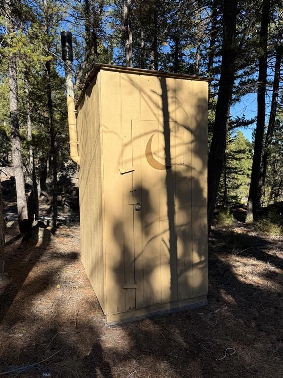
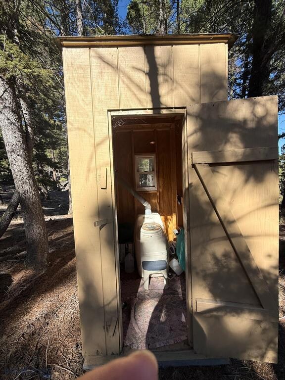
Whether you are searching for country property to build your dream home, a secluded cabin retreat, or a hunting base-camp, this 20-acre parcel delivers. Beautifully landscaped by Mother Nature with immense boulder outcroppings, trees, natural grasses, flowers, magnificent views of the Tobacco Root Mountain Range. This area is rich in recreation, scenery, trail systems, wildlife. Slow down, relax and enjoy the special lifestyle that comes with the beautiful surroundings, tranquility and recreational opportunities. Conveniently located about halfway between Butte and Whitehall off Highway 2. Good, year-round access. The property includes a cozy tiny house (approximately 200 square feet) with a well and electric. (Check out the aerial video attached to this listing). The Seller also owns the adjoining 20 acres, the entire 40 acres is listed separately. MLS# 30060514
Listing Agent
Century 21 Shea Realty - Butte License #RRE-BRO-LIC-10976 Listed on: 11/10/2025

Property Details
Property Type
- Land
Est. Annual Taxes
- $750
Lot Details
- 20 Acre Lot
Community Details
- No Home Owners Association
Listing and Financial Details
- Assessor Parcel Number 51099509101010000
Map
Home Values in the Area
Average Home Value in this Area
Tax History
| Year | Tax Paid | Tax Assessment Tax Assessment Total Assessment is a certain percentage of the fair market value that is determined by local assessors to be the total taxable value of land and additions on the property. | Land | Improvement |
|---|---|---|---|---|
| 2025 | $652 | $100,237 | $0 | $0 |
| 2024 | $587 | $62,207 | $0 | $0 |
| 2023 | $594 | $61,637 | $0 | $0 |
| 2022 | $570 | $48,042 | $0 | $0 |
| 2021 | $391 | $48,042 | $0 | $0 |
| 2020 | $522 | $43,589 | $0 | $0 |
| 2019 | $508 | $43,589 | $0 | $0 |
| 2018 | $338 | $18,213 | $0 | $0 |
| 2017 | $178 | $18,213 | $0 | $0 |
| 2016 | $315 | $17,611 | $0 | $0 |
| 2015 | $175 | $17,611 | $0 | $0 |
| 2014 | $192 | $9,838 | $0 | $0 |
Property History
| Date | Event | Price | List to Sale | Price per Sq Ft |
|---|---|---|---|---|
| 11/10/2025 11/10/25 | For Sale | $249,000 | -43.9% | -- |
| 10/27/2025 10/27/25 | For Sale | $444,000 | -- | -- |
Purchase History
| Date | Type | Sale Price | Title Company |
|---|---|---|---|
| Warranty Deed | -- | Fidelity National Title | |
| Quit Claim Deed | -- | None Listed On Document |
Mortgage History
| Date | Status | Loan Amount | Loan Type |
|---|---|---|---|
| Open | $200,000 | New Conventional |
Source: Montana Regional MLS
MLS Number: 30061100
APN: 51-0995-09-1-01-01-0000
Disclaimer: Certain information contained herein is derived from information provided by parties other than Homes.com. All information provided is deemed reliable, but is not guaranteed to be accurate and should be independently verified.
![]() IDX information is provided exclusively for personal, non-commercial use, and may not be used for any purpose other than to identify prospective properties consumers may be interested in purchasing. Information is deemed reliable but not guaranteed.
IDX information is provided exclusively for personal, non-commercial use, and may not be used for any purpose other than to identify prospective properties consumers may be interested in purchasing. Information is deemed reliable but not guaranteed.
- tbd Upper Rader Creek Rd
- tbd Upper Radar Creek Rd
- 91 Upper Radar Creek Rd
- 16 Friendspring Rd
- 11 Lost Moose Bend
- 180 Lower Rader Creek Rd
- TBD Friendspring Rd
- 456 Friendspring Rd
- 189 Blacktail Canyon Rd
- LOT 6 Tbd Stonecrop Rd
- LOT 2 Tbd Stonecrop Rd
- 34 Appe Ln
- 967 Mt Highway 2 W
- 842 Mt Highway 2 W
- 207 Cyprus Dr
- 2171 Janney Rd
- 420 Terra Verde Dr
- 426 Friend Spring Rd
- 101 Terra Verde Dr
- 360 Roosevelt Dr
- 783 Mt-2 Unit ID1051228P
- 783 Mt-2 Unit ID1051615P
- 783 Mt-2 Unit ID1051216P
- 759 Mt-2 Unit ID1060677P
- 2505 Hancock Ave
- 3204-3216 Busch St Unit 3208
- 920 S Colorado St Unit 920
- 826 S Montana St
- 709 Indiana St
- 421 S Washington St
- 219 S Washington St Unit A
- 514 W Park St Unit 1
- 858 W Silver St
- 816 W Mercury St
- 939 W Granite St Unit A
- 215-1/2 N Emmett
- 215 N Emmett Ave
- 963 Lewisohn St Unit 5A
- 406 W Daly St
- 23 Brimstone St Unit B