Estimated Value: $1,225,595 - $1,679,000
3
Beds
3
Baths
2,320
Sq Ft
$623/Sq Ft
Est. Value
About This Home
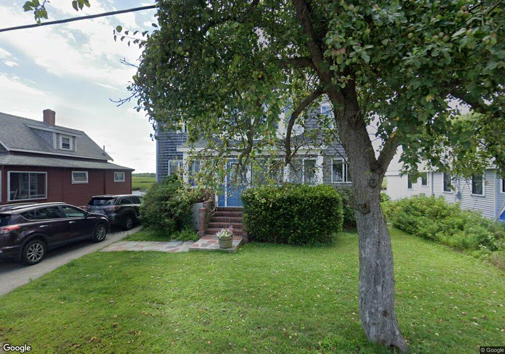
This home is located at 91 Webhannet Dr, Wells, ME 04090 and is currently estimated at $1,444,649, approximately $622 per square foot. 91 Webhannet Dr is a home located in York County with nearby schools including Wells Junior High School, Wells Elementary School, and Wells High School.
Ownership History
Date
Name
Owned For
Owner Type
Purchase Details
Closed on
Nov 8, 2012
Sold by
Grant John J and Peters Virginia M
Bought by
Clark Amy B and Clark James F
Current Estimated Value
Home Financials for this Owner
Home Financials are based on the most recent Mortgage that was taken out on this home.
Original Mortgage
$520,000
Outstanding Balance
$353,371
Interest Rate
3.42%
Mortgage Type
Purchase Money Mortgage
Estimated Equity
$1,091,278
Purchase Details
Closed on
Oct 13, 2010
Sold by
Peters Grant Virginia M
Bought by
Peters-Grant Virginia M and Grant John J
Home Financials for this Owner
Home Financials are based on the most recent Mortgage that was taken out on this home.
Original Mortgage
$200,000
Interest Rate
4.51%
Mortgage Type
Unknown
Create a Home Valuation Report for This Property
The Home Valuation Report is an in-depth analysis detailing your home's value as well as a comparison with similar homes in the area
Home Values in the Area
Average Home Value in this Area
Purchase History
| Date | Buyer | Sale Price | Title Company |
|---|---|---|---|
| Clark Amy B | -- | -- | |
| Clark Amy B | -- | -- | |
| Peters-Grant Virginia M | -- | -- |
Source: Public Records
Mortgage History
| Date | Status | Borrower | Loan Amount |
|---|---|---|---|
| Open | Clark Amy B | $520,000 | |
| Closed | Peters-Grant Virginia M | $520,000 | |
| Previous Owner | Peters-Grant Virginia M | $200,000 |
Source: Public Records
Tax History
| Year | Tax Paid | Tax Assessment Tax Assessment Total Assessment is a certain percentage of the fair market value that is determined by local assessors to be the total taxable value of land and additions on the property. | Land | Improvement |
|---|---|---|---|---|
| 2025 | $7,322 | $1,133,510 | $737,830 | $395,680 |
| 2024 | $6,892 | $1,133,510 | $737,830 | $395,680 |
| 2023 | $6,756 | $1,133,510 | $737,830 | $395,680 |
| 2022 | $6,574 | $628,450 | $433,110 | $195,340 |
| 2021 | $6,611 | $628,450 | $433,110 | $195,340 |
| 2020 | $6,586 | $628,450 | $433,110 | $195,340 |
| 2019 | $6,548 | $628,450 | $433,110 | $195,340 |
| 2018 | $6,486 | $628,450 | $433,110 | $195,340 |
| 2017 | $6,385 | $628,450 | $433,110 | $195,340 |
| 2016 | $6,322 | $628,450 | $433,110 | $195,340 |
| 2015 | $6,253 | $628,450 | $433,110 | $195,340 |
| 2013 | $5,731 | $628,450 | $433,110 | $195,340 |
Source: Public Records
Map
Nearby Homes
- 376 Mile Rd Unit 104
- 273 Webhannet Dr Unit 9
- 301 Webhannet Dr
- 60 Merrifield Ct
- 403 Webhannet Dr
- 835 Ocean Ave
- 1072 Post Rd Unit 111
- 4 Tidal Ct
- 9 Robert Ln
- 191 Eldridge Rd
- 189 Eldridge Rd
- 733 Post Rd Unit 212
- 46 Buffum Hill Rd
- 133 Eldridge Rd
- 15 Heather Ln
- 48 Howard Ave
- 542 Ocean Ave
- 1351 Post Rd Unit 49
- 1373 Post Rd Unit 8E
- 1373 Post Rd Unit 4E
Your Personal Tour Guide
Ask me questions while you tour the home.