Estimated Value: $202,000 - $693,048
3
Beds
2
Baths
1,990
Sq Ft
$190/Sq Ft
Est. Value
About This Home
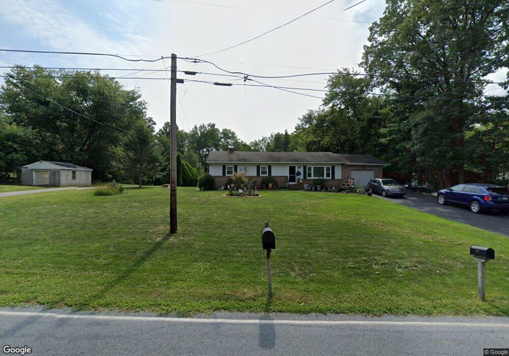
This home is located at 910 Buck Rd, Dover, PA 17315 and is currently estimated at $378,349, approximately $190 per square foot. 910 Buck Rd is a home located in York County with nearby schools including Northeastern Senior High School.
Ownership History
Date
Name
Owned For
Owner Type
Purchase Details
Closed on
Nov 22, 2002
Sold by
Naill Michelle D and Naill Harry W
Bought by
Laird David A and Olsavsky David G
Current Estimated Value
Home Financials for this Owner
Home Financials are based on the most recent Mortgage that was taken out on this home.
Original Mortgage
$279,200
Outstanding Balance
$118,148
Interest Rate
6.16%
Estimated Equity
$260,201
Purchase Details
Closed on
Nov 14, 2002
Sold by
Naill Michelle D and Naill Harry W
Bought by
Goodwin Craig R and Goodwin Heather M
Home Financials for this Owner
Home Financials are based on the most recent Mortgage that was taken out on this home.
Original Mortgage
$279,200
Outstanding Balance
$118,148
Interest Rate
6.16%
Estimated Equity
$260,201
Create a Home Valuation Report for This Property
The Home Valuation Report is an in-depth analysis detailing your home's value as well as a comparison with similar homes in the area
Home Values in the Area
Average Home Value in this Area
Purchase History
| Date | Buyer | Sale Price | Title Company |
|---|---|---|---|
| Laird David A | $75,000 | -- | |
| Goodwin Craig R | $120,000 | -- |
Source: Public Records
Mortgage History
| Date | Status | Borrower | Loan Amount |
|---|---|---|---|
| Open | Laird David A | $279,200 |
Source: Public Records
Tax History Compared to Growth
Tax History
| Year | Tax Paid | Tax Assessment Tax Assessment Total Assessment is a certain percentage of the fair market value that is determined by local assessors to be the total taxable value of land and additions on the property. | Land | Improvement |
|---|---|---|---|---|
| 2025 | $8,848 | $246,180 | $3,830 | $242,350 |
| 2024 | $8,648 | $246,180 | $3,830 | $242,350 |
| 2023 | $8,648 | $246,180 | $3,830 | $242,350 |
| 2022 | $8,594 | $246,180 | $3,830 | $242,350 |
| 2021 | $8,355 | $246,110 | $3,760 | $242,350 |
| 2020 | $8,355 | $246,110 | $3,760 | $242,350 |
| 2019 | $8,245 | $246,110 | $3,760 | $242,350 |
| 2018 | $8,205 | $246,110 | $3,760 | $242,350 |
| 2017 | $8,205 | $246,110 | $3,760 | $242,350 |
| 2016 | $0 | $246,110 | $3,760 | $242,350 |
| 2015 | -- | $245,970 | $3,620 | $242,350 |
| 2014 | -- | $246,450 | $4,100 | $242,350 |
Source: Public Records
Map
Nearby Homes
- 850 Buck Rd
- 90 Vida Ln
- 5010 Bull Rd
- 160 Vida Ln
- 2530 Mill Creek Rd
- 5680 Crone Rd
- 6031 Mountain Rd
- 460 Maple Run Dr
- 140 Eli Dr
- 345 Maple Run Dr
- 130 Eli Dr
- 120 Eli Dr
- 325 Grantway Dr
- 45 Eli Dr
- Griffin Plan at Sagebrook
- Wynn Plan at Sagebrook
- Maeve II Plan at Sagebrook
- Maeve Plan at Sagebrook
- 285 Grantway Dr
- 135 Amber Ln