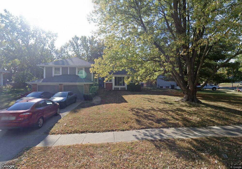
910 Dunwich Dr Liberty, MO 64068
Estimated Value: $308,049 - $331,000
3
Beds
3
Baths
1,529
Sq Ft
$207/Sq Ft
Est. Value
About This Home
This home is located at 910 Dunwich Dr, Liberty, MO 64068 and is currently estimated at $316,512, approximately $207 per square foot. 910 Dunwich Dr is a home located in Clay County with nearby schools including Alexander Doniphan Elementary School, Liberty Middle School, and Liberty High School.
Ownership History
Date
Name
Owned For
Owner Type
Purchase Details
Closed on
Jul 21, 1997
Sold by
Stumph Richard Dale and Stumph Tammy L
Bought by
Hagen Andrew P and Hagen Becky L
Current Estimated Value
Home Financials for this Owner
Home Financials are based on the most recent Mortgage that was taken out on this home.
Original Mortgage
$88,000
Outstanding Balance
$10,699
Interest Rate
5.75%
Estimated Equity
$305,813
Create a Home Valuation Report for This Property
The Home Valuation Report is an in-depth analysis detailing your home's value as well as a comparison with similar homes in the area
Home Values in the Area
Average Home Value in this Area
Purchase History
| Date | Buyer | Sale Price | Title Company |
|---|---|---|---|
| Hagen Andrew P | -- | Thomson Title Corp |
Source: Public Records
Mortgage History
| Date | Status | Borrower | Loan Amount |
|---|---|---|---|
| Open | Hagen Andrew P | $88,000 |
Source: Public Records
Tax History Compared to Growth
Tax History
| Year | Tax Paid | Tax Assessment Tax Assessment Total Assessment is a certain percentage of the fair market value that is determined by local assessors to be the total taxable value of land and additions on the property. | Land | Improvement |
|---|---|---|---|---|
| 2025 | $2,708 | $40,450 | -- | -- |
| 2024 | $2,708 | $35,210 | -- | -- |
| 2023 | $2,754 | $35,210 | $0 | $0 |
| 2022 | $2,556 | $32,260 | $0 | $0 |
| 2021 | $2,536 | $32,262 | $7,220 | $25,042 |
| 2020 | $2,592 | $30,970 | $0 | $0 |
| 2019 | $2,592 | $30,970 | $0 | $0 |
| 2018 | $2,280 | $26,750 | $0 | $0 |
| 2017 | $2,259 | $26,750 | $4,560 | $22,190 |
| 2016 | $2,259 | $26,750 | $4,560 | $22,190 |
| 2015 | $2,259 | $26,750 | $4,560 | $22,190 |
| 2014 | $2,164 | $25,420 | $4,370 | $21,050 |
Source: Public Records
Map
Nearby Homes
- 862 Amesbury Ave
- 918 Amesbury Ave
- 1110 Canterbury Ln
- 1105 Bristol Way
- 1331 Park Ln
- 1317 Park Ln
- 716 Bristol Ct
- 1209 Liberty Drive Terrace
- 1124 Amesbury Ave
- 1218 Canterbury Ln
- 442 Circle Dr
- 1304 Wellington Way
- 1327 Easton Ct
- 1507 Amesbury Ave
- 1025 Orchard Ave
- 1733 Welleslay Ln
- 509 Belmont St
- 420 Belmont St
- 828 W Brown St
- 1030 Maple Woods Dr
- 916 Dunwich Dr
- 906 Dunwich Dr
- 922 Dunwich Dr
- 915 Canterbury Ln
- 902 Dunwich Dr
- 854 York Place
- 863 Dunwich Dr
- 928 Dunwich Dr
- 859 Canterbury Ln
- 907 Dunwich Dr
- 923 Canterbury Ln
- 913 Dunwich Dr
- 934 Dunwich Dr
- 853 Canterbury Ln
- 850 York Place
- 929 Canterbury Ln
- 847 York Place
- 1003 Essex St
- 919 Dunwich Dr
- 906 Canterbury Ln