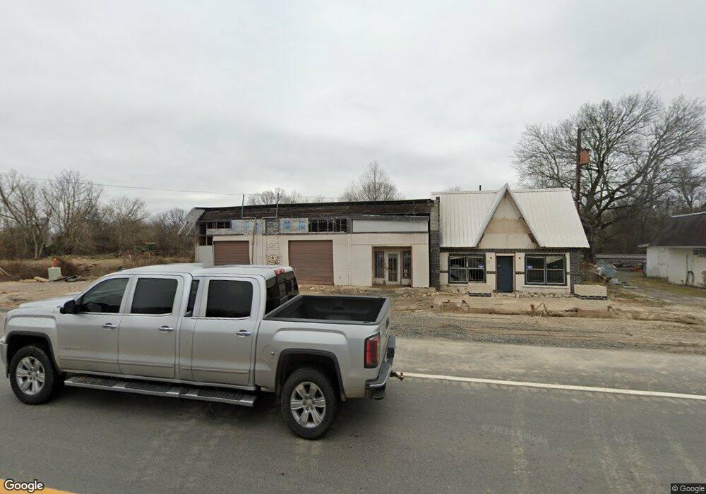
910 Highway 67 S Arkadelphia, AR 71923
--
Bed
--
Bath
2,319
Sq Ft
1.25
Acres
About This Home
This home is located at 910 Highway 67 S, Arkadelphia, AR 71923. 910 Highway 67 S is a home located in Clark County with nearby schools including Louisa Perritt Primary School, Central Primary School, and Peake Elementary School.
Ownership History
Date
Name
Owned For
Owner Type
Purchase Details
Closed on
Mar 15, 2012
Sold by
Southern Bancorp Bank
Bought by
Green'S Diesel & Restoration Llc
Home Financials for this Owner
Home Financials are based on the most recent Mortgage that was taken out on this home.
Original Mortgage
$20,970
Interest Rate
3.91%
Mortgage Type
Commercial
Purchase Details
Closed on
Jul 27, 2010
Sold by
Commissioner Of State Lands
Bought by
Southern Bancorp Bank
Purchase Details
Closed on
Mar 2, 2007
Bought by
Dykes Jack and Dykes Robin
Purchase Details
Closed on
Sep 1, 1993
Bought by
Neagle
Purchase Details
Closed on
Nov 1, 1991
Bought by
Neagle Arthur J and Neagle Betty
Purchase Details
Closed on
Jul 2, 1985
Bought by
Neagle Arthur J and Neagle Betty
Purchase Details
Closed on
Jul 1, 1985
Bought by
Neagle Arthur J and Neagle Betty
Create a Home Valuation Report for This Property
The Home Valuation Report is an in-depth analysis detailing your home's value as well as a comparison with similar homes in the area
Home Values in the Area
Average Home Value in this Area
Purchase History
| Date | Buyer | Sale Price | Title Company |
|---|---|---|---|
| Green'S Diesel & Restoration Llc | -- | -- | |
| Southern Bancorp Bank | $14,000 | -- | |
| Dykes Jack | $35,000 | -- | |
| Hurst Robert | $35,000 | -- | |
| Neagle | -- | -- | |
| Neagle Arthur J | -- | -- | |
| Neagle Arthur J | -- | -- | |
| Neagle Arthur J | -- | -- |
Source: Public Records
Mortgage History
| Date | Status | Borrower | Loan Amount |
|---|---|---|---|
| Closed | Green'S Diesel & Restoration Llc | $20,970 |
Source: Public Records
Tax History Compared to Growth
Tax History
| Year | Tax Paid | Tax Assessment Tax Assessment Total Assessment is a certain percentage of the fair market value that is determined by local assessors to be the total taxable value of land and additions on the property. | Land | Improvement |
|---|---|---|---|---|
| 2024 | $333 | $6,440 | $2,500 | $3,940 |
| 2023 | $333 | $6,440 | $2,500 | $3,940 |
| 2022 | $333 | $6,440 | $2,500 | $3,940 |
| 2021 | $333 | $6,440 | $2,500 | $3,940 |
| 2020 | $333 | $6,440 | $2,500 | $3,940 |
| 2019 | $321 | $6,210 | $2,500 | $3,710 |
| 2018 | $318 | $6,210 | $2,500 | $3,710 |
| 2017 | $318 | $6,210 | $2,500 | $3,710 |
| 2016 | $318 | $6,210 | $2,500 | $3,710 |
| 2015 | $318 | $6,210 | $2,500 | $3,710 |
| 2014 | $295 | $6,490 | $2,500 | $3,990 |
Source: Public Records
Map
Nearby Homes
- 833 Wade St
- 1028 S 11th St
- 1507 Cutler St
- 801 Crittenden St
- TBD Walnut St
- 1514 Walnut St
- 1516 Walnut St
- 0 Joan Trail Unit 25134081
- 1043 Clinton St
- 1103 Caddo St
- Hwy 7 Arkansas 7
- 1437 Lincoln St
- 227 S Austin St
- 309 Hardin St
- 1703 O'Connell St
- 303 Hardin St
- 1327 Hunter St
- 211 Cherry St
- 1803 Sylvia St
- 312 Riverside Dr