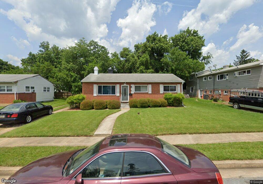
910 Marksworth Rd Catonsville, MD 21228
Estimated Value: $336,344 - $368,000
3
Beds
1
Bath
1,174
Sq Ft
$299/Sq Ft
Est. Value
About This Home
This home is located at 910 Marksworth Rd, Catonsville, MD 21228 and is currently estimated at $351,586, approximately $299 per square foot. 910 Marksworth Rd is a home located in Baltimore County with nearby schools including Johnnycake Elementary School, Southwest Academy, and Woodlawn High School.
Ownership History
Date
Name
Owned For
Owner Type
Purchase Details
Closed on
Dec 16, 2010
Sold by
Walsh Kathryn M
Bought by
Cotten Gary Roland and Cotten Pamela A
Current Estimated Value
Home Financials for this Owner
Home Financials are based on the most recent Mortgage that was taken out on this home.
Original Mortgage
$214,500
Outstanding Balance
$141,716
Interest Rate
4.22%
Mortgage Type
VA
Estimated Equity
$209,870
Purchase Details
Closed on
Apr 28, 2009
Sold by
Dutton Mary L
Bought by
Walsh Kathryn M and Merz Andrew J
Create a Home Valuation Report for This Property
The Home Valuation Report is an in-depth analysis detailing your home's value as well as a comparison with similar homes in the area
Home Values in the Area
Average Home Value in this Area
Purchase History
| Date | Buyer | Sale Price | Title Company |
|---|---|---|---|
| Cotten Gary Roland | $210,000 | -- | |
| Walsh Kathryn M | $140,000 | -- |
Source: Public Records
Mortgage History
| Date | Status | Borrower | Loan Amount |
|---|---|---|---|
| Open | Cotten Gary Roland | $214,500 |
Source: Public Records
Tax History Compared to Growth
Tax History
| Year | Tax Paid | Tax Assessment Tax Assessment Total Assessment is a certain percentage of the fair market value that is determined by local assessors to be the total taxable value of land and additions on the property. | Land | Improvement |
|---|---|---|---|---|
| 2025 | $3,613 | $274,633 | -- | -- |
| 2024 | $3,613 | $251,900 | $77,100 | $174,800 |
| 2023 | $1,726 | $245,367 | $0 | $0 |
| 2022 | $3,309 | $238,833 | $0 | $0 |
| 2021 | $3,125 | $232,300 | $77,100 | $155,200 |
| 2020 | $3,125 | $224,567 | $0 | $0 |
| 2019 | $3,051 | $216,833 | $0 | $0 |
| 2018 | $2,935 | $209,100 | $63,600 | $145,500 |
| 2017 | $2,718 | $197,767 | $0 | $0 |
| 2016 | $3,086 | $186,433 | $0 | $0 |
| 2015 | $3,086 | $175,100 | $0 | $0 |
| 2014 | $3,086 | $175,100 | $0 | $0 |
Source: Public Records
Map
Nearby Homes
- 1007 Marksworth Rd
- 6028 Moorehead Rd
- 1007 Kent Ave
- 930 Sedgley Rd
- 920 Vanderwood Rd
- 908 Vanderwood Rd
- 6001 Johnnycake Rd
- 6011 Johnnycake Rd
- 1009 Rowe Ln
- 1068 Craftswood Rd
- 1109 Marksworth Rd
- 67 Walden Mill Way
- 3 Mcgrady Square
- 800 Crosby Rd
- 1113 Kent Ave
- 6031 Burnt Oak Rd
- 1124 Brigadoon Trail
- 1124 Dorchester Ave
- 5911 Carroll St
- 6200 Gilston Park Rd
- 912 Marksworth Rd
- 908 Marksworth Rd
- 6034 Craigmont Rd
- 906 Marksworth Rd
- 6001 Sherrill Rd
- 914 Marksworth Rd
- 921 Marksworth Rd
- 6036 Craigmont Rd
- 923 Marksworth Rd
- 925 Marksworth Rd
- 917 Marksworth Rd
- 6003 Sherrill Rd
- 6000 Sherrill Rd
- 6038 Craigmont Rd
- 927 Marksworth Rd
- 915 Marksworth Rd
- 922 Kent Ave
- 920 Kent Ave
- 1001 Collwood Rd
- 924 Kent Ave