


910 Monument Dr Freeport, TX 77541
Estimated payment $1,675/month
Highlights
- Bay View
- Central Heating and Cooling System
- 1-Story Property
- Traditional Architecture
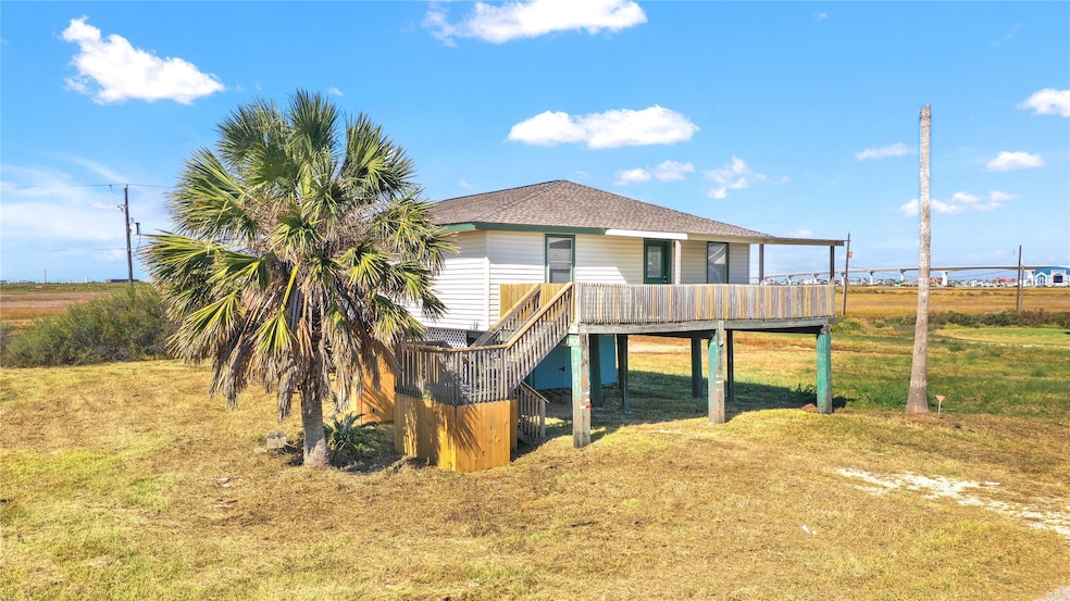
About This Home
Located on the quiet side of Surfside Beach, this 3-bedroom, 2-bath home offers peaceful views of the wetlands, Intracoastal Waterway, and Surfside Bridge. The spacious floor plan includes a large living area, open kitchen and dining room, and a roomy primary suite. A smaller entry room works well as a guest space or office. Recent updates include a new roof (2025) and HVAC (2022). The property includes an additional lot for a total of 10,500 sq ft—offering plenty of options. If the stairs were relocated, the second lot could be cleared for resale or future development. Enjoy the partially covered deck, outdoor shower, and large storage area below. Just a short golf cart ride to the beach, this is a great opportunity to create your own coastal retreat. Buyer to verify any development potential or building restrictions with the City of Surfside Beach. Call to schedule your showing today!
Home Details
Home Type
- Single Family
Est. Annual Taxes
- $5,340
Year Built
- Built in 1970
Lot Details
- 10,500 Sq Ft Lot
- Additional Parcels
Property Views
- Bay
- Canal
Home Design
- Traditional Architecture
- Composition Roof
- Metal Roof
- Vinyl Siding
Interior Spaces
- 1,320 Sq Ft Home
- 1-Story Property
- Electric Oven
- Washer and Electric Dryer Hookup
Bedrooms and Bathrooms
- 3 Bedrooms
- 2 Full Bathrooms
Parking
- Workshop in Garage
- Driveway
Schools
- Freeport Elementary School
- O'hara Lanier Middle School
- Brazosport High School
Utilities
- Central Heating and Cooling System
Community Details
- Surfside Subdivision
Map
Tax History
| Year | Tax Paid | Tax Assessment Tax Assessment Total Assessment is a certain percentage of the fair market value that is determined by local assessors to be the total taxable value of land and additions on the property. | Land | Improvement |
|---|---|---|---|---|
| 2025 | $5,238 | $285,000 | $46,860 | $238,140 |
| 2023 | $5,238 | $285,855 | $33,080 | $252,775 |
| 2022 | $4,497 | $204,000 | $23,890 | $180,110 |
| 2021 | $3,543 | $152,390 | $17,500 | $134,890 |
| 2020 | $3,569 | $150,000 | $17,500 | $132,500 |
| 2019 | $4,186 | $169,780 | $15,240 | $154,540 |
| 2018 | $3,390 | $136,500 | $12,980 | $123,520 |
| 2017 | $3,628 | $145,770 | $12,980 | $132,790 |
| 2016 | $3,111 | $125,000 | $6,040 | $118,960 |
| 2015 | $2,732 | $115,000 | $5,250 | $109,750 |
| 2014 | $2,732 | $106,070 | $4,730 | $101,340 |
Property History
| Date | Event | Price | List to Sale | Price per Sq Ft |
|---|---|---|---|---|
| 03/16/2026 03/16/26 | Price Changed | $230,000 | -8.0% | $174 / Sq Ft |
| 11/07/2025 11/07/25 | For Sale | $250,000 | -- | $189 / Sq Ft |
Purchase History
| Date | Type | Sale Price | Title Company |
|---|---|---|---|
| Interfamily Deed Transfer | -- | None Available | |
| Vendors Lien | -- | Alamo Title 02 |
Mortgage History
| Date | Status | Loan Amount | Loan Type |
|---|---|---|---|
| Open | $45,050 | No Value Available |
Source: Houston Association of REALTORS®
MLS Number: 17276064
APN: 7875-0394-000
Disclaimer: Certain information contained herein is derived from information provided by parties other than Homes.com. All information provided is deemed reliable, but is not guaranteed to be accurate and should be independently verified.
![]() Copyright 2026, Houston REALTORS® Information Service, Inc.
Copyright 2026, Houston REALTORS® Information Service, Inc.
The information provided is exclusively for consumers’ personal, non-commercial use, and may not be used for any purpose other than to identify prospective properties consumers may be interested in purchasing.
Information is deemed reliable but not guaranteed.
- 512 Caisson St
- 902 Treaty Dr
- 511 Caisson St
- 00 Treaty Dr
- 0 Militia Dr
- 424 Angel Wing St
- 714 Caisson St
- TBD Monument Dr
- 514 Texas St
- 433 Seabean St
- 1120 Monument Dr
- 818 Fort Velasco Dr
- 1010 Fort Velasco Dr
- 1110 Treaty Dr
- 416 Seabean St
- 000 Texas St
- 722 Ft Velasco Dr
- 0 Treaty Dr Unit 94709559
- 310 Angel Wing St Unit 312
- 528 Thunder Rd
- 414 Caisson St
- 1019 Treaty Dr
- 738 Caisson St
- 805 Seashell Dr
- 1111 Surf Dr
- 308 Parkview Rd
- 510 Oyster St
- 210 Surf Dr
- 24 King Fish Ln
- 81 Santar Loop
- 123 W 6th St Unit 2
- 126 W 6th St Unit 2
- 126 W 6th St Unit 3
- 231 W Broad St
- 429 W 2nd St Unit 1/2
- 710 W 7th St
- 727 W 5th St Unit 1-A
- 727 W 5th St
- 811 W 7th St
- 2734 Duncan Dr

Ask me questions while you tour the home.