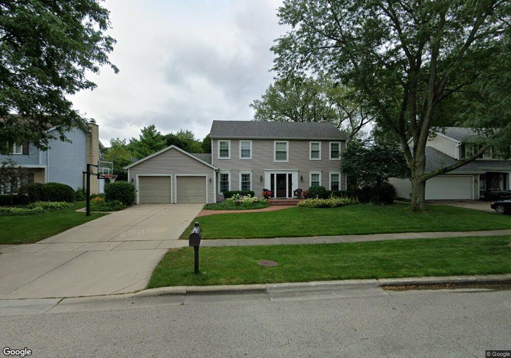
910 S Dymond Rd Libertyville, IL 60048
Cambridge-Liberty Village NeighborhoodEstimated Value: $637,493 - $736,000
4
Beds
3
Baths
2,612
Sq Ft
$266/Sq Ft
Est. Value
About This Home
This home is located at 910 S Dymond Rd, Libertyville, IL 60048 and is currently estimated at $694,123, approximately $265 per square foot. 910 S Dymond Rd is a home located in Lake County with nearby schools including Rockland Elementary School, Highland Middle School, and Libertyville High School.
Ownership History
Date
Name
Owned For
Owner Type
Purchase Details
Closed on
Apr 3, 2024
Sold by
Foster Adam D and Foster Victoria
Bought by
Foster Family Trust and Foster
Current Estimated Value
Purchase Details
Closed on
Aug 30, 2005
Sold by
Toth Mark and Toth Elizabeth Ann
Bought by
Foster Adam D and Foster Victoria
Home Financials for this Owner
Home Financials are based on the most recent Mortgage that was taken out on this home.
Original Mortgage
$472,000
Interest Rate
5.83%
Mortgage Type
New Conventional
Create a Home Valuation Report for This Property
The Home Valuation Report is an in-depth analysis detailing your home's value as well as a comparison with similar homes in the area
Home Values in the Area
Average Home Value in this Area
Purchase History
| Date | Buyer | Sale Price | Title Company |
|---|---|---|---|
| Foster Family Trust | -- | None Listed On Document | |
| Foster Adam D | $590,000 | -- |
Source: Public Records
Mortgage History
| Date | Status | Borrower | Loan Amount |
|---|---|---|---|
| Previous Owner | Foster Adam D | $472,000 |
Source: Public Records
Tax History Compared to Growth
Tax History
| Year | Tax Paid | Tax Assessment Tax Assessment Total Assessment is a certain percentage of the fair market value that is determined by local assessors to be the total taxable value of land and additions on the property. | Land | Improvement |
|---|---|---|---|---|
| 2024 | $13,144 | $185,626 | $66,439 | $119,187 |
| 2023 | $12,656 | $171,210 | $61,279 | $109,931 |
| 2022 | $12,656 | $164,248 | $58,900 | $105,348 |
| 2021 | $12,185 | $160,712 | $57,632 | $103,080 |
| 2020 | $11,726 | $158,010 | $56,663 | $101,347 |
| 2019 | $11,534 | $157,815 | $56,124 | $101,691 |
| 2018 | $11,600 | $161,758 | $55,896 | $105,862 |
| 2017 | $11,282 | $156,651 | $54,131 | $102,520 |
| 2016 | $11,224 | $152,667 | $51,324 | $101,343 |
| 2015 | $11,123 | $142,693 | $47,971 | $94,722 |
| 2014 | $9,950 | $128,279 | $45,073 | $83,206 |
| 2012 | $9,609 | $126,857 | $44,573 | $82,284 |
Source: Public Records
Map
Nearby Homes
- 1017 Juniper Pkwy
- 2245 Hazeltime Dr
- 777 Garfield Ave Unit A
- 747 Garfield Ave Unit C
- 501 Hemlock Ln
- 422 Shadow Creek Dr
- 851 Garfield Ave Unit C
- 533 Drake St
- 323 W Golf Rd
- 1137 Pine Tree Ln
- 0 Ames St
- 423 Ames St
- 1969 Royal Birkdale Dr
- 20924 & 20902 W Park Ave
- 1330 W Park Ave
- 164 W Golf Rd Unit A
- 1939 Lake Charles Dr
- 1933 Lake Charles Dr
- 223 Kenloch Ave
- 551 W Park Ave Unit E
- 912 S Dymond Rd
- 906 S Dymond Rd Unit 3
- 913 Warwick Ln
- 911 Warwick Ln
- 914 S Dymond Rd
- 904 S Dymond Rd
- 915 Warwick Ln
- 1001 Dover Ct
- 907 S Dymond Rd
- 917 Warwick Ln
- 907 Warwick Ln
- 916 S Dymond Rd
- 915 S Dymond Rd
- 909 W Golf Rd
- 901 W Golf Rd
- 1004 Dover Ct
- 903 S Dymond Rd
- 1007 Dover Ct
- 919 Warwick Ln
- 917 S Dymond Rd