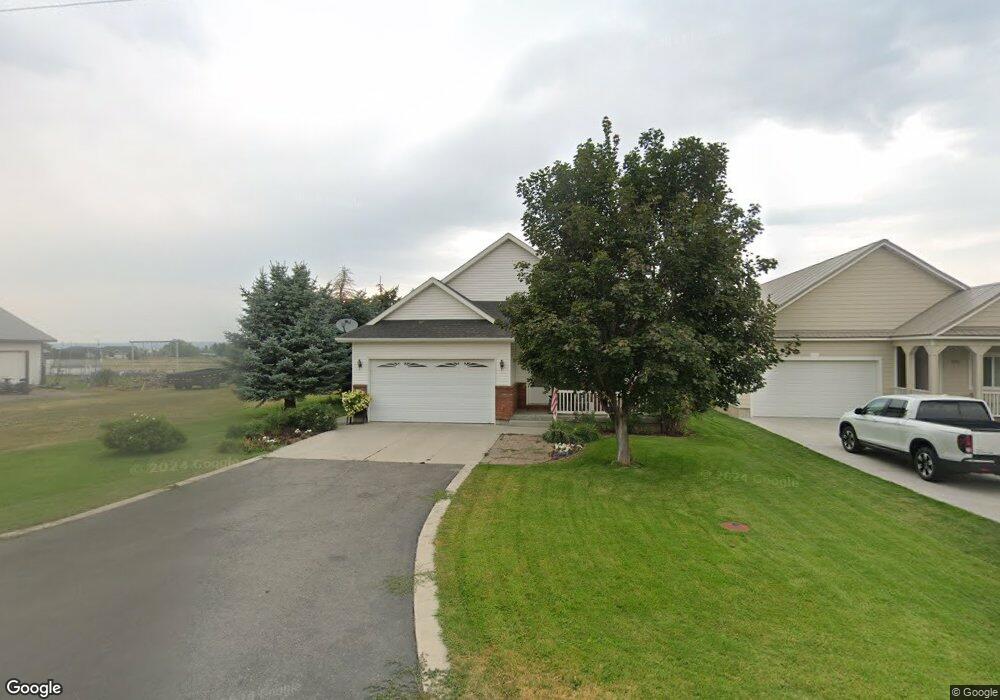
911 Cherry St Ashton, ID 83420
Estimated Value: $294,000 - $704,000
2
Beds
1
Bath
1,674
Sq Ft
$279/Sq Ft
Est. Value
About This Home
This home is located at 911 Cherry St, Ashton, ID 83420 and is currently estimated at $467,763, approximately $279 per square foot. 911 Cherry St is a home with nearby schools including Ashton Elementary School and North Fremont Junior/Senior High School.
Ownership History
Date
Name
Owned For
Owner Type
Purchase Details
Closed on
Jul 19, 2021
Sold by
Beard David Wayne and Beard Jerrine Kay
Bought by
Beard David Wayne and Beard Jerrine Kay
Current Estimated Value
Purchase Details
Closed on
Dec 21, 2020
Sold by
Baum Ladawn and Oberhansley Dennis Wayne
Bought by
Beard David Wayne and Beard Jerrine Kay
Purchase Details
Closed on
Aug 14, 2008
Sold by
Stronks Theodore Robert and Stronks Delena Rae
Bought by
Oberhansley Georgia
Create a Home Valuation Report for This Property
The Home Valuation Report is an in-depth analysis detailing your home's value as well as a comparison with similar homes in the area
Purchase History
| Date | Buyer | Sale Price | Title Company |
|---|---|---|---|
| Beard David Wayne | -- | First American Title Rexburg | |
| Beard David Wayne | -- | First American Title Rexburg | |
| Oberhansley Georgia | -- | -- |
Source: Public Records
Tax History
| Year | Tax Paid | Tax Assessment Tax Assessment Total Assessment is a certain percentage of the fair market value that is determined by local assessors to be the total taxable value of land and additions on the property. | Land | Improvement |
|---|---|---|---|---|
| 2025 | $1,808 | $195,917 | $13,975 | $181,942 |
| 2024 | $1,760 | $188,609 | $13,975 | $174,634 |
| 2023 | $1,608 | $188,609 | $13,975 | $174,634 |
| 2022 | $1,984 | $129,169 | $13,000 | $116,169 |
| 2021 | $3,736 | $199,748 | $11,375 | $188,373 |
| 2020 | $3,431 | $177,322 | $11,375 | $165,947 |
| 2019 | $1,784 | $88,660 | $11,375 | $77,285 |
| 2018 | $1,709 | $81,933 | $11,375 | $70,558 |
| 2017 | $17 | $72,045 | $11,034 | $61,011 |
| 2016 | $1,604 | $72,045 | $11,034 | $61,011 |
| 2015 | $1,587 | $144,149 | $0 | $0 |
| 2014 | $1,365 | $72,074 | $0 | $0 |
| 2013 | $1,365 | $72,074 | $0 | $0 |
Source: Public Records
Map
Nearby Homes
- 885 Maple St
- 863 Maple St
- 118 N 8th St Unit 2
- LOTS 1-3 E 1300 Rd N
- Lot 22 Sunflower Ln
- 511 Id-47
- 641 Fremont St
- 417 Main St
- 540 N 4th St Unit 6
- 161 Walnut St
- 137 Spruce St
- L2 BLK 1 E 1300 Rd N
- 1331 N 3687 E
- L4A B2 N 3706 E
- L5A B2 N 3706 E
- L6A B2 N 3706 E
- 3656 Fishermans Dr
- 3660 E 1100 N
- 1105 N 3400 E
- 1640 Ashton Hill Loop
Your Personal Tour Guide
Ask me questions while you tour the home.