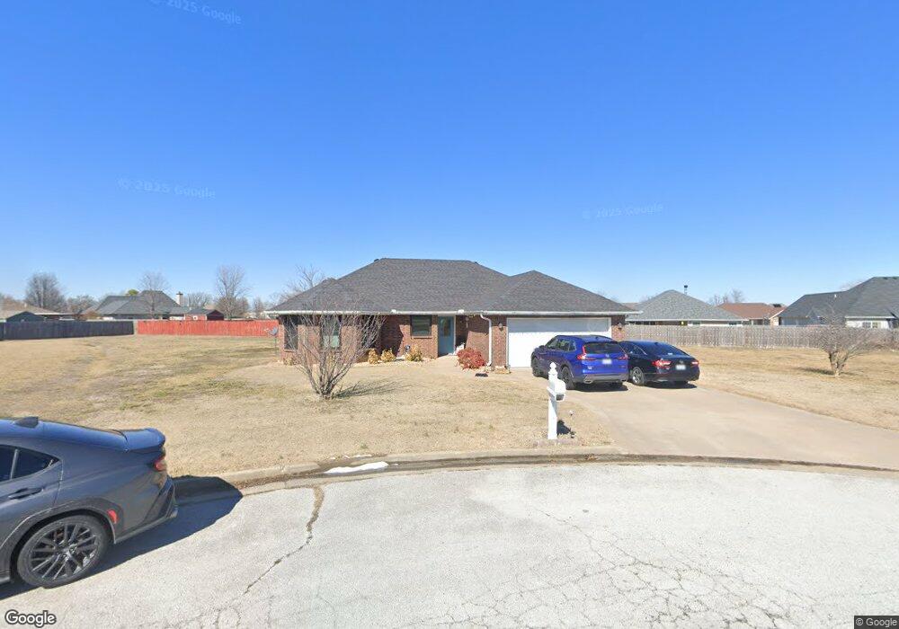
911 Katlin Cir Carl Junction, MO 64834
Estimated Value: $248,547 - $281,000
3
Beds
2
Baths
1,526
Sq Ft
$172/Sq Ft
Est. Value
About This Home
This home is located at 911 Katlin Cir, Carl Junction, MO 64834 and is currently estimated at $261,887, approximately $171 per square foot. 911 Katlin Cir is a home located in Jasper County with nearby schools including Carl Junction Primary School (K-1), Carl Junction Intermediate School, and Carl Junction Primary School (2-3).
Ownership History
Date
Name
Owned For
Owner Type
Purchase Details
Closed on
Sep 1, 2005
Sold by
Red Wood Development Inc
Bought by
Roland Troy S and Roland Heather M
Current Estimated Value
Home Financials for this Owner
Home Financials are based on the most recent Mortgage that was taken out on this home.
Original Mortgage
$99,200
Outstanding Balance
$50,810
Interest Rate
5.37%
Mortgage Type
Fannie Mae Freddie Mac
Estimated Equity
$211,077
Purchase Details
Closed on
May 11, 2004
Sold by
Brill Cecil
Bought by
Red Wood Development Inc
Create a Home Valuation Report for This Property
The Home Valuation Report is an in-depth analysis detailing your home's value as well as a comparison with similar homes in the area
Purchase History
| Date | Buyer | Sale Price | Title Company |
|---|---|---|---|
| Roland Troy S | -- | -- | |
| Red Wood Development Inc | -- | -- |
Source: Public Records
Mortgage History
| Date | Status | Borrower | Loan Amount |
|---|---|---|---|
| Open | Roland Troy S | $99,200 | |
| Closed | Roland Troy S | $24,800 |
Source: Public Records
Tax History
| Year | Tax Paid | Tax Assessment Tax Assessment Total Assessment is a certain percentage of the fair market value that is determined by local assessors to be the total taxable value of land and additions on the property. | Land | Improvement |
|---|---|---|---|---|
| 2025 | $1,493 | $28,740 | $3,520 | $25,220 |
| 2024 | $1,502 | $25,520 | $3,520 | $22,000 |
| 2023 | $1,502 | $25,520 | $3,520 | $22,000 |
| 2022 | $1,635 | $27,690 | $3,520 | $24,170 |
| 2021 | $1,402 | $27,690 | $3,520 | $24,170 |
| 2020 | $1,316 | $25,540 | $3,520 | $22,020 |
| 2019 | $1,249 | $25,540 | $3,520 | $22,020 |
| 2018 | $1,271 | $26,050 | $0 | $0 |
| 2017 | $1,275 | $26,050 | $0 | $0 |
| 2016 | $1,288 | $26,580 | $0 | $0 |
Source: Public Records
Map
Nearby Homes
- 904 Larson St
- Tract 3 Prairie Ln
- Tract 2 Prairie Ln
- Tract 1 Prairie Ln
- Tract 4 Prairie Ln
- 711 Prairie Ln
- 817 Delaney Dr
- TBD Route Yy
- 29320 State Highway Yy
- 29250 State Highway Yy
- 505 N Broadway Ave
- 9129 Cr-290
- 809 Aberdeen Ave
- 106 S Roney St
- 901 Aberdeen Ave
- 509 W Gault St
- 304 Belgian Blue Blvd
- 501 W Walton Ave
- 409 W Walton Ave
- 804 Aberdeen Ave
Your Personal Tour Guide
Ask me questions while you tour the home.