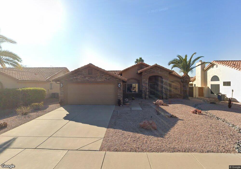
9117 W Tonto Ln Peoria, AZ 85382
Estimated Value: $379,292 - $466,000
2
Beds
2
Baths
1,461
Sq Ft
$282/Sq Ft
Est. Value
About This Home
This home is located at 9117 W Tonto Ln, Peoria, AZ 85382 and is currently estimated at $412,573, approximately $282 per square foot. 9117 W Tonto Ln is a home located in Maricopa County with nearby schools including Apache Elementary School, Sunrise Mountain High School, and Sonoran Science Academy-Peoria.
Ownership History
Date
Name
Owned For
Owner Type
Purchase Details
Closed on
Dec 21, 2009
Sold by
Larson Diana Kay
Bought by
Milich Carl N and Milich Lois M
Current Estimated Value
Purchase Details
Closed on
Jul 24, 2007
Sold by
Hensley James R
Bought by
Suggs Clarence E and Suggs Mary Jane
Purchase Details
Closed on
Feb 22, 2002
Sold by
Karg William F and Karg Norma J
Bought by
Hensley James R
Purchase Details
Closed on
Jan 25, 2000
Sold by
Beron Giles and Beron Joan
Bought by
Karg William F and Karg Norma J
Home Financials for this Owner
Home Financials are based on the most recent Mortgage that was taken out on this home.
Original Mortgage
$114,400
Interest Rate
8.24%
Mortgage Type
New Conventional
Create a Home Valuation Report for This Property
The Home Valuation Report is an in-depth analysis detailing your home's value as well as a comparison with similar homes in the area
Home Values in the Area
Average Home Value in this Area
Purchase History
| Date | Buyer | Sale Price | Title Company |
|---|---|---|---|
| Milich Carl N | $179,000 | First American Title Ins Co | |
| Suggs Clarence E | $257,000 | First American Title Ins Co | |
| Hensley James R | $144,000 | Capital Title Agency Inc | |
| Karg William F | $143,000 | North American Title Agency |
Source: Public Records
Mortgage History
| Date | Status | Borrower | Loan Amount |
|---|---|---|---|
| Previous Owner | Karg William F | $114,400 |
Source: Public Records
Tax History Compared to Growth
Tax History
| Year | Tax Paid | Tax Assessment Tax Assessment Total Assessment is a certain percentage of the fair market value that is determined by local assessors to be the total taxable value of land and additions on the property. | Land | Improvement |
|---|---|---|---|---|
| 2025 | $1,582 | $20,900 | -- | -- |
| 2024 | $1,602 | $19,905 | -- | -- |
| 2023 | $1,602 | $28,500 | $5,700 | $22,800 |
| 2022 | $1,569 | $23,430 | $4,680 | $18,750 |
| 2021 | $1,680 | $22,000 | $4,400 | $17,600 |
| 2020 | $1,696 | $20,800 | $4,160 | $16,640 |
| 2019 | $1,641 | $19,130 | $3,820 | $15,310 |
| 2018 | $1,587 | $17,930 | $3,580 | $14,350 |
| 2017 | $1,587 | $16,380 | $3,270 | $13,110 |
| 2016 | $1,571 | $15,330 | $3,060 | $12,270 |
| 2015 | $1,466 | $14,620 | $2,920 | $11,700 |
Source: Public Records
Map
Nearby Homes
- 9203 W Behrend Dr
- 19810 N 90th Ln
- 19817 N 92nd Ave
- 19812 N 90th Dr
- 9130 W Utopia Rd
- 8942 W Sequoia Dr
- 19835 N 90th Ln
- 9051 W Marco Polo Rd
- 9238 W Behrend Dr
- 9064 W Marco Polo Rd
- 9013 W Marco Polo Rd
- 8874 W Piute Ave
- 9152 W Escuda Dr
- 20138 N 92nd Ave
- 20143 N 92nd Ave
- 8839 W Rimrock Dr
- 20149 N 92nd Ave
- 9032 W Sierra Pinta Dr
- 8823 W Rimrock Dr
- 19249 N 93rd Dr Unit 52
- 9123 W Tonto Ln
- 9111 W Tonto Ln
- 9106 W Oraibi Dr
- 9102 W Oraibi Dr
- 9129 W Tonto Ln
- 9120 W Tonto Ln
- 9114 W Oraibi Dr
- 9126 W Tonto Ln
- 9135 W Tonto Ln
- 9118 W Oraibi Dr
- 9132 W Tonto Ln
- 19512 N 90th Ln
- 19518 N 90th Ln
- 19516 N 90th Ln
- 9109 W Oraibi Dr
- 9138 W Tonto Ln
- 19508 N 90th Ln
- 9105 W Oraibi Dr
- 9113 W Oraibi Dr
- 9101 W Oraibi Dr