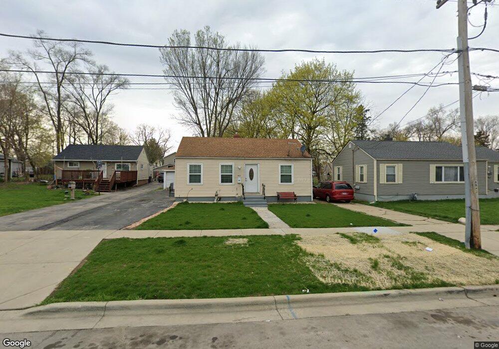
912 Cookane Ave Elgin, IL 60120
Southeast Elgin NeighborhoodEstimated Value: $205,000 - $242,000
About This Home
This home is located at 912 Cookane Ave, Elgin, IL 60120 and is currently estimated at $222,104, approximately $289 per square foot. 912 Cookane Ave is a home located in Kane County with nearby schools including Nature Ridge Elementary School, Kenyon Woods Middle School, and South Elgin High School.
Ownership History
We collect this data history from publicly available records. To have your information removed, we recommend requesting removal directly through your county’s website.
Purchase Details
Home Financials for this Owner
Home Financials are based on the most recent Mortgage that was taken out on this home.Home Values in the Area
Average Home Value in this Area
Purchase History
We collect this data history from publicly available records. To have your information removed, we recommend requesting removal directly through your county’s website.
| Date | Buyer | Sale Price | Title Company |
|---|---|---|---|
| $152,000 | Chicago Title Insurance Comp |
Mortgage History
We collect this data history from publicly available records. To have your information removed, we recommend requesting removal directly through your county’s website.
| Date | Status | Borrower | Loan Amount |
|---|---|---|---|
| Closed | $144,400 |
Tax History
We collect this data history from publicly available records. To have your information removed, we recommend requesting removal directly through your county’s website.
| Year | Tax Paid | Tax Assessment Tax Assessment Total Assessment is a certain percentage of the fair market value that is determined by local assessors to be the total taxable value of land and additions on the property. | Land | Improvement |
|---|---|---|---|---|
| 2024 | $3,462 | $51,259 | $12,632 | $38,627 |
| 2023 | $3,266 | $46,309 | $11,412 | $34,897 |
| 2022 | $3,141 | $42,226 | $10,406 | $31,820 |
| 2021 | $2,987 | $39,478 | $9,729 | $29,749 |
| 2020 | $2,767 | $36,336 | $9,288 | $27,048 |
| 2019 | $2,672 | $34,612 | $8,847 | $25,765 |
| 2018 | $2,229 | $28,541 | $8,334 | $20,207 |
| 2017 | $2,158 | $26,982 | $7,879 | $19,103 |
| 2016 | $2,030 | $25,032 | $7,310 | $17,722 |
| 2015 | -- | $22,944 | $6,700 | $16,244 |
| 2014 | -- | $22,660 | $6,617 | $16,043 |
| 2013 | -- | $26,164 | $6,792 | $19,372 |
Map
- 711 Bluff City Blvd
- 648 S Liberty St
- 555 S Liberty St
- 513 Cookane Ave
- 515 Illinois Ave
- 433 Arlington Ave
- 1563 Deer Pointe Dr
- 700 Villa St
- 1182 Concord Dr
- 447 Ashland Ave
- 383 Woodview Cir Unit A
- 394 Woodview Cir Unit B
- 402 Woodview Cir Unit D
- 1101 Yorkshire Ct Unit D
- 483 Barrett St
- 1103 Stratford Ct Unit C
- 286 Villa St
- 420 Blue Heron Cir
- 765 Thorndale Dr
- 311 Ryerson Ave
- 918 Cookane Ave
- 908 Cookane Ave
- 920 Cookane Ave
- 926 Cookane Ave
- 915 Lavoie Ave
- 917 Lavoie Ave
- 911 Lavoie Ave
- 919 Lavoie Ave
- 919 Cookane Ave
- 913 Cookane Ave
- 930 Cookane Ave
- 903 Lavoie Ave
- 925 Cookane Ave
- 921 Lavoie Ave
- 903 Cookane Ave
- 933 Cookane Ave
- 700 Elgin Ave
- 722 Dixon Ave
- 939 Cookane Ave
- 755 Dixon Ave
Ask me questions while you tour the home.