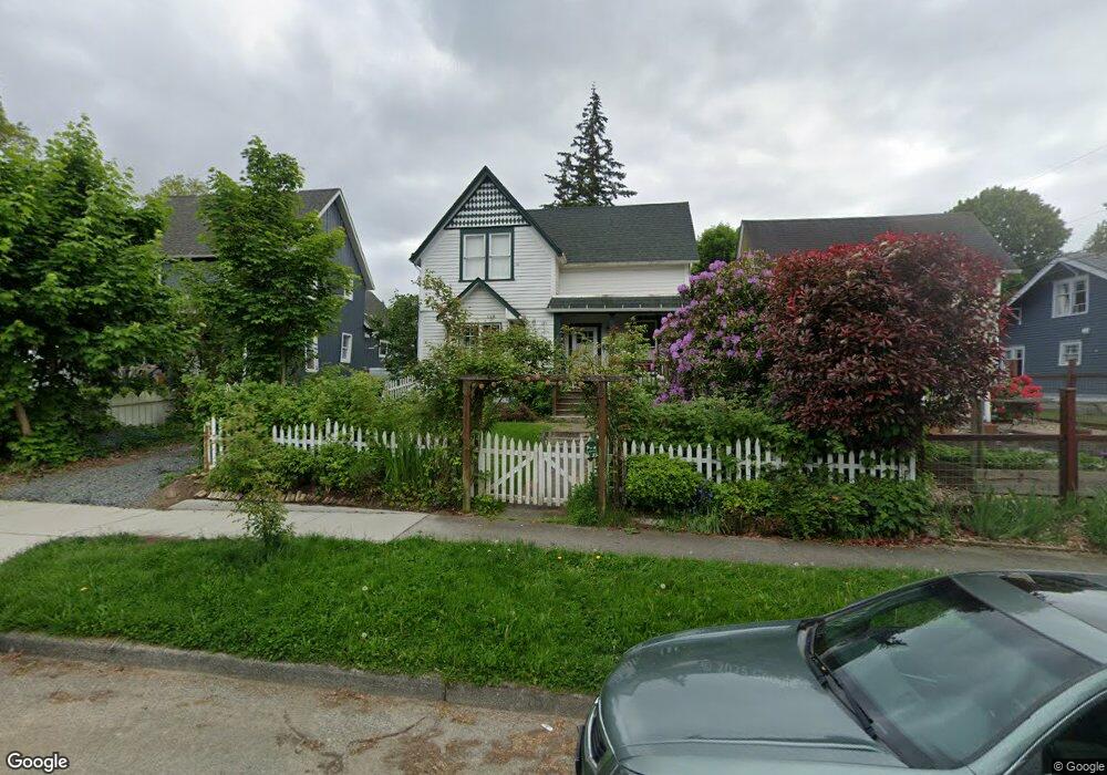
912 E Maple St Bellingham, WA 98225
Sehome NeighborhoodEstimated Value: $771,000 - $961,000
4
Beds
2
Baths
1,866
Sq Ft
$463/Sq Ft
Est. Value
About This Home
This home is located at 912 E Maple St, Bellingham, WA 98225 and is currently estimated at $864,667, approximately $463 per square foot. 912 E Maple St is a home located in Whatcom County with nearby schools including Happy Valley Elementary School, Fairhaven Middle School, and Sehome High School.
Ownership History
Date
Name
Owned For
Owner Type
Purchase Details
Closed on
Jul 2, 2018
Sold by
Lahud Zahner Ricardo
Bought by
Lahud Zahner Erika
Current Estimated Value
Purchase Details
Closed on
Sep 27, 2000
Sold by
Meek Richard A and Meek Gwendolyn K
Bought by
Lahud Zahner Ricardo and Lahud Zahner Erika
Home Financials for this Owner
Home Financials are based on the most recent Mortgage that was taken out on this home.
Original Mortgage
$50,000
Outstanding Balance
$17,325
Interest Rate
7.98%
Estimated Equity
$847,342
Create a Home Valuation Report for This Property
The Home Valuation Report is an in-depth analysis detailing your home's value as well as a comparison with similar homes in the area
Home Values in the Area
Average Home Value in this Area
Purchase History
| Date | Buyer | Sale Price | Title Company |
|---|---|---|---|
| Lahud Zahner Erika | -- | None Available | |
| Lahud Zahner Ricardo | $114,000 | First American Title Ins |
Source: Public Records
Mortgage History
| Date | Status | Borrower | Loan Amount |
|---|---|---|---|
| Open | Lahud Zahner Ricardo | $50,000 |
Source: Public Records
Tax History
| Year | Tax Paid | Tax Assessment Tax Assessment Total Assessment is a certain percentage of the fair market value that is determined by local assessors to be the total taxable value of land and additions on the property. | Land | Improvement |
|---|---|---|---|---|
| 2025 | $6,158 | $774,948 | $319,488 | $455,460 |
| 2024 | $6,004 | $752,387 | $310,187 | $442,200 |
| 2023 | $6,004 | $771,543 | $318,084 | $453,459 |
| 2022 | $4,103 | $653,863 | $269,568 | $384,295 |
| 2021 | $4,067 | $441,735 | $210,600 | $231,135 |
| 2020 | $3,260 | $413,260 | $195,000 | $218,260 |
| 2019 | $3,071 | $320,146 | $133,200 | $186,946 |
| 2018 | $3,094 | $302,370 | $125,874 | $176,496 |
| 2017 | $1,347 | $260,460 | $108,180 | $152,280 |
| 2016 | $2,407 | $237,032 | $98,370 | $138,662 |
| 2015 | $2,412 | $220,433 | $92,790 | $127,643 |
| 2014 | -- | $213,805 | $90,000 | $123,805 |
| 2013 | -- | $209,883 | $88,500 | $121,383 |
Source: Public Records
Map
Nearby Homes
- 1028 Billy Frank Jr St Unit 301
- 1205 E Maple St
- 924 N Garden St Unit 201
- 819 High St Unit 101
- 819 High St Unit 317
- 826 N Garden St
- 119 N Samish Way Unit 30
- 1126 N Forest St
- 901 N Forest St Unit 123
- 901 N Forest St Unit 109
- 1031 N State St Unit 107
- 1001 N State St Unit 209
- 1001 N State St Unit 403
- 715 N Garden St Unit 502
- 820 N State St Unit 520
- 820 N State St Unit 505
- 820 N State St Unit 521
- 820 N State St Unit 513
- 125 S 34th St
- 310 E Ivy St
- 910 E Maple St
- 916 E Maple St
- 1021 Liberty St
- 908 E Maple St
- 1 E Maple St
- 906 E Maple St
- 1017 Liberty St
- 1020 Key St
- 900 E Maple St
- 1000 E Maple St
- 1016 Key St
- 911 E Maple St
- 1013 Liberty St
- 919 E Maple St
- 1107-1109 Liberty St
- 909 E Maple St
- 901 E Maple St
- 1022 Liberty St
- 905 E Maple St
- 1006 E Maple St
Your Personal Tour Guide
Ask me questions while you tour the home.