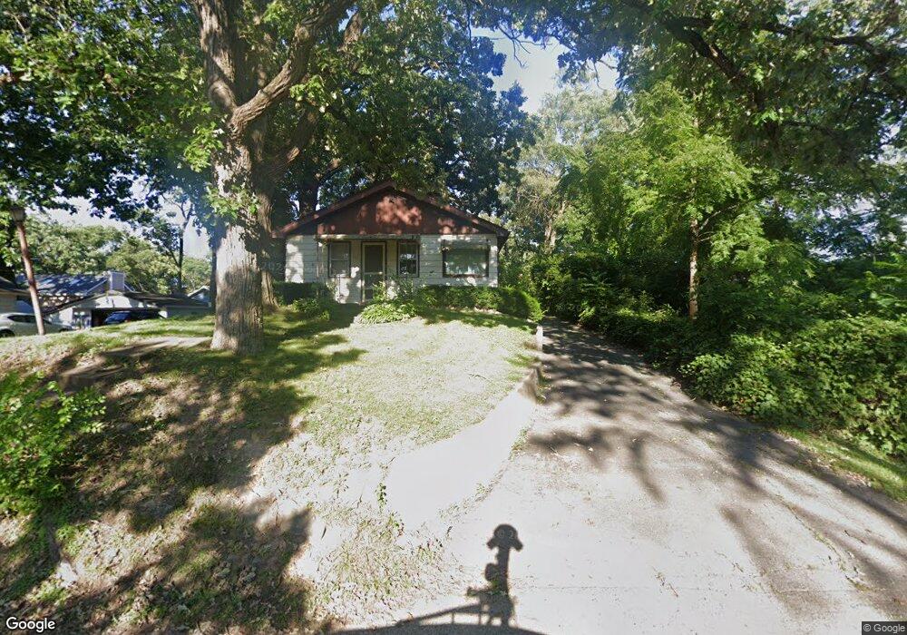
912 Monroe St Wauconda, IL 60084
Estimated Value: $176,293 - $235,000
Studio
1
Bath
864
Sq Ft
$239/Sq Ft
Est. Value
About This Home
This home is located at 912 Monroe St, Wauconda, IL 60084 and is currently estimated at $206,073, approximately $238 per square foot. 912 Monroe St is a home located in Lake County with nearby schools including Wauconda Grade School, Wauconda Middle School, and Wauconda High School.
Ownership History
Date
Name
Owned For
Owner Type
Purchase Details
Closed on
Jan 8, 2026
Sold by
Daun Jason and Daun Kristen
Bought by
Daun Grace C
Current Estimated Value
Home Financials for this Owner
Home Financials are based on the most recent Mortgage that was taken out on this home.
Original Mortgage
$285,000
Outstanding Balance
$285,000
Interest Rate
6.13%
Mortgage Type
New Conventional
Estimated Equity
-$78,927
Purchase Details
Closed on
Mar 1, 2011
Sold by
Land Group
Bought by
Gagliardo Paulette
Purchase Details
Closed on
Dec 7, 2010
Sold by
Helander Willard R
Bought by
Land Group
Purchase Details
Closed on
May 5, 1996
Sold by
Atkins Dean R
Bought by
Caffrey Paulette M
Create a Home Valuation Report for This Property
The Home Valuation Report is an in-depth analysis detailing your home's value as well as a comparison with similar homes in the area
Home Values in the Area
Average Home Value in this Area
Purchase History
| Date | Buyer | Sale Price | Title Company |
|---|---|---|---|
| Daun Grace C | $300,000 | First American Title | |
| Gagliardo Paulette | $61,000 | None Available | |
| Land Group | -- | None Available | |
| Caffrey Paulette M | $104,000 | -- |
Source: Public Records
Mortgage History
| Date | Status | Borrower | Loan Amount |
|---|---|---|---|
| Open | Daun Grace C | $285,000 |
Source: Public Records
Tax History
| Year | Tax Paid | Tax Assessment Tax Assessment Total Assessment is a certain percentage of the fair market value that is determined by local assessors to be the total taxable value of land and additions on the property. | Land | Improvement |
|---|---|---|---|---|
| 2024 | $3,607 | $40,164 | $8,365 | $31,799 |
| 2023 | $3,735 | $36,713 | $7,646 | $29,067 |
| 2022 | $3,735 | $34,234 | $9,750 | $24,484 |
| 2021 | $3,581 | $32,348 | $9,213 | $23,135 |
| 2020 | $3,479 | $30,831 | $8,781 | $22,050 |
| 2019 | $3,101 | $29,138 | $8,299 | $20,839 |
| 2018 | $3,031 | $26,336 | $9,841 | $16,495 |
| 2017 | $3,051 | $26,031 | $9,727 | $16,304 |
| 2016 | $2,857 | $24,650 | $9,211 | $15,439 |
| 2015 | $2,706 | $22,629 | $8,456 | $14,173 |
| 2014 | $3,222 | $25,797 | $9,497 | $16,300 |
| 2012 | $3,118 | $27,596 | $9,086 | $18,510 |
Source: Public Records
Map
Nearby Homes
- 818 Sheridan Dr
- 1114 Jackson Ave
- 701 Lake Shore Dr
- 0 Bonner Rd
- 905 Grand Blvd
- 1017 Grand Blvd
- 1260 Water Stone Cir
- 428 Country Lane Ct Unit 301
- 417 Lake Shore Blvd
- 505 Woodland Ave
- 28722 N Madison Ave
- 365 Lake Ave Unit C
- 28331 W Main St
- 902 Highland Ave
- 304 Hill St Unit 1004
- 360 Promontory Ln Unit B
- 360 Promontory Ln Unit D
- 28855 N Garland Rd
- 159 Parkview Dr Unit 159
- 235 Crestview Dr Unit A
Your Personal Tour Guide
Ask me questions while you tour the home.