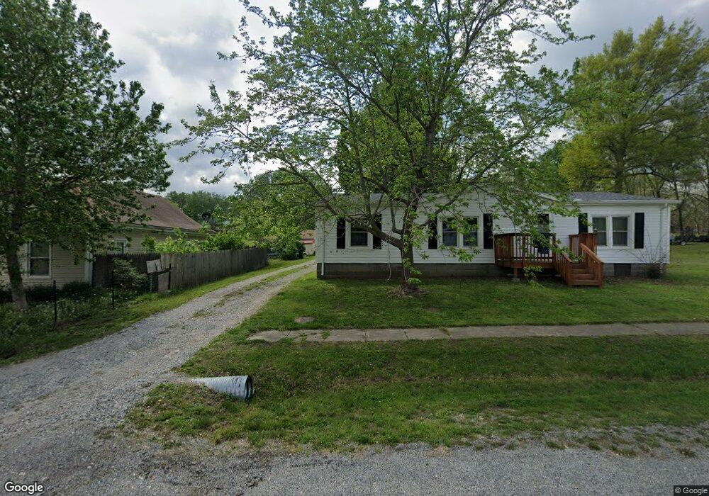
912 N Main St Clarksdale, MO 64430
Estimated Value: $208,389 - $252,000
2
Beds
2
Baths
1,308
Sq Ft
$176/Sq Ft
Est. Value
About This Home
This home is located at 912 N Main St, Clarksdale, MO 64430 and is currently estimated at $229,847, approximately $175 per square foot. 912 N Main St is a home with nearby schools including Maysville Elementary School and Maysville Junior/Senior High School.
Ownership History
Date
Name
Owned For
Owner Type
Purchase Details
Closed on
Jan 6, 2021
Sold by
Us Bank National Association
Bought by
Thompson William C and Thompson Charity D
Current Estimated Value
Purchase Details
Closed on
Jan 5, 2021
Sold by
Us Bank Na
Bought by
Thompson William C and Thompson Charity D
Purchase Details
Closed on
Jun 22, 2007
Sold by
Burrell Larry D and Burrell Carol E
Bought by
Thompson Brent D
Home Financials for this Owner
Home Financials are based on the most recent Mortgage that was taken out on this home.
Original Mortgage
$15,000
Interest Rate
6.16%
Mortgage Type
Stand Alone Second
Create a Home Valuation Report for This Property
The Home Valuation Report is an in-depth analysis detailing your home's value as well as a comparison with similar homes in the area
Purchase History
| Date | Buyer | Sale Price | Title Company |
|---|---|---|---|
| Thompson William C | -- | First American Title | |
| Thompson William C | -- | None Available | |
| Thompson Brent D | -- | Advantage Title Llc |
Source: Public Records
Mortgage History
| Date | Status | Borrower | Loan Amount |
|---|---|---|---|
| Previous Owner | Thompson Brent D | $15,000 |
Source: Public Records
Tax History
| Year | Tax Paid | Tax Assessment Tax Assessment Total Assessment is a certain percentage of the fair market value that is determined by local assessors to be the total taxable value of land and additions on the property. | Land | Improvement |
|---|---|---|---|---|
| 2025 | $1,380 | $20,480 | $2,950 | $17,530 |
| 2024 | $1,193 | $18,120 | $2,610 | $15,510 |
| 2023 | $1,191 | $18,120 | $2,610 | $15,510 |
| 2022 | $1,142 | $17,380 | $2,610 | $14,770 |
| 2021 | $1,140 | $17,380 | $2,610 | $14,770 |
| 2020 | $1,130 | $17,190 | $2,420 | $14,770 |
| 2019 | $1,127 | $17,190 | $2,420 | $14,770 |
| 2018 | $1,112 | $17,190 | $0 | $17,190 |
| 2017 | $1,140 | $17,190 | $0 | $17,190 |
| 2016 | $1,151 | $17,190 | $0 | $0 |
| 2015 | -- | $17,190 | $0 | $0 |
| 2012 | -- | $17,190 | $0 | $0 |
Source: Public Records
Map
Nearby Homes
- 0 State Hwy O N A Unit HMS2614823
- 0 County Road 269
- TBD State Route N
- 6474 SW Oakridge Rd
- 0 Main St Unit 2415604
- 9818 SW Ogle Rd
- 402 W 4th St
- 9881 NW 356th St
- 0 Spring Holler SE
- Spring Holler Rd
- 20652 State Route Z
- 3799 E Lowell St
- 0 SE 36 Hwy
- 639 Leidy St
- 631 Leidy St
- 2103 NE 85th Rd
- 18031 State Route O
- 0 Tba Southwest Corner of Hwy 33 and N Unit 11607554
- Lot 101 Timber Ct
- 0 NW Gospel Rd
Your Personal Tour Guide
Ask me questions while you tour the home.