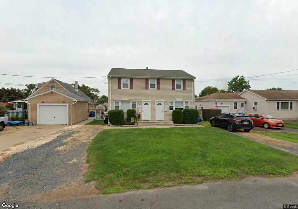
912 Newark Ave Manville, NJ 08835
Estimated Value: $495,000 - $540,000
--
Bed
--
Bath
1,716
Sq Ft
$304/Sq Ft
Est. Value
About This Home
This home is located at 912 Newark Ave, Manville, NJ 08835 and is currently estimated at $521,049, approximately $303 per square foot. 912 Newark Ave is a home located in Somerset County with nearby schools including Weston Elementary School, Roosevelt School, and Alexander Batcho Intermediate School (ABIS).
Ownership History
Date
Name
Owned For
Owner Type
Purchase Details
Closed on
Jan 7, 2021
Sold by
Lacosta Dennis and Lacosta Dawn
Bought by
Perez Stefanny Campos and Perez Cartin Elizabeth
Current Estimated Value
Home Financials for this Owner
Home Financials are based on the most recent Mortgage that was taken out on this home.
Original Mortgage
$353,479
Interest Rate
3%
Mortgage Type
FHA
Purchase Details
Closed on
Aug 25, 2003
Sold by
Milon Builders Llc
Bought by
Dennis Lacosta and Lacosta Dawn
Home Financials for this Owner
Home Financials are based on the most recent Mortgage that was taken out on this home.
Original Mortgage
$232,000
Interest Rate
6.22%
Create a Home Valuation Report for This Property
The Home Valuation Report is an in-depth analysis detailing your home's value as well as a comparison with similar homes in the area
Home Values in the Area
Average Home Value in this Area
Purchase History
| Date | Buyer | Sale Price | Title Company |
|---|---|---|---|
| Perez Stefanny Campos | $360,000 | Title Masters Llc | |
| Dennis Lacosta | $290,000 | -- |
Source: Public Records
Mortgage History
| Date | Status | Borrower | Loan Amount |
|---|---|---|---|
| Previous Owner | Perez Stefanny Campos | $353,479 | |
| Previous Owner | Dennis Lacosta | $232,000 |
Source: Public Records
Tax History Compared to Growth
Tax History
| Year | Tax Paid | Tax Assessment Tax Assessment Total Assessment is a certain percentage of the fair market value that is determined by local assessors to be the total taxable value of land and additions on the property. | Land | Improvement |
|---|---|---|---|---|
| 2025 | $9,150 | $437,600 | $243,500 | $194,100 |
| 2024 | $9,150 | $406,500 | $216,000 | $190,500 |
| 2023 | $9,123 | $379,500 | $201,000 | $178,500 |
| 2022 | $9,274 | $354,500 | $176,000 | $178,500 |
| 2021 | $8,487 | $287,000 | $146,000 | $141,000 |
| 2020 | $8,083 | $256,700 | $126,000 | $130,700 |
| 2019 | $8,030 | $245,800 | $126,000 | $119,800 |
| 2018 | $7,776 | $237,800 | $116,000 | $121,800 |
| 2017 | $7,482 | $232,800 | $111,000 | $121,800 |
| 2016 | $7,212 | $232,800 | $111,000 | $121,800 |
| 2015 | $7,894 | $326,600 | $172,000 | $154,600 |
| 2014 | $7,737 | $326,600 | $172,000 | $154,600 |
Source: Public Records
Map
Nearby Homes
- 202 Jasinski Ave
- 911 Bound Brook Ave
- 909 Newark Ave
- 905 Bound Brook Ave
- 925 Bound Brook Ave
- 913 Newark Ave
- 203 Jasinski Ave
- 921 Newark Ave
- 831 Newark Ave
- 908 E Frech Ave
- 1007 Bound Brook Ave
- 305 N Greasheimer St
- 914 Bound Brook Ave
- 830 Newark Ave
- 835 Bound Brook Ave
- 912 E Frech Ave
- 832 E Frech Ave
- 200 White Ave
- 920 E Frech Ave
- 202 White Ave