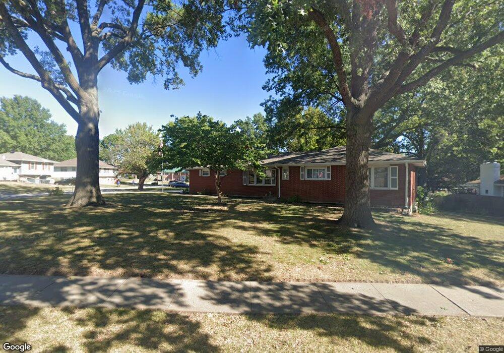
912 NW Kabel St Blue Springs, MO 64015
Estimated Value: $268,107 - $314,000
3
Beds
2
Baths
1,262
Sq Ft
$225/Sq Ft
Est. Value
About This Home
This home is located at 912 NW Kabel St, Blue Springs, MO 64015 and is currently estimated at $283,777, approximately $224 per square foot. 912 NW Kabel St is a home located in Jackson County with nearby schools including Thomas J. Ultican Elementary School, Paul Kinder Middle School, and Blue Springs High School.
Ownership History
Date
Name
Owned For
Owner Type
Purchase Details
Closed on
Jun 9, 2000
Sold by
Timm Richard L and Timm Peggy L
Bought by
Russell W Dale and Russell Penelope A
Current Estimated Value
Home Financials for this Owner
Home Financials are based on the most recent Mortgage that was taken out on this home.
Original Mortgage
$30,500
Outstanding Balance
$10,814
Interest Rate
8.3%
Mortgage Type
Purchase Money Mortgage
Estimated Equity
$272,963
Create a Home Valuation Report for This Property
The Home Valuation Report is an in-depth analysis detailing your home's value as well as a comparison with similar homes in the area
Home Values in the Area
Average Home Value in this Area
Purchase History
| Date | Buyer | Sale Price | Title Company |
|---|---|---|---|
| Russell W Dale | -- | Chicago Title Co |
Source: Public Records
Mortgage History
| Date | Status | Borrower | Loan Amount |
|---|---|---|---|
| Open | Russell W Dale | $30,500 |
Source: Public Records
Tax History Compared to Growth
Tax History
| Year | Tax Paid | Tax Assessment Tax Assessment Total Assessment is a certain percentage of the fair market value that is determined by local assessors to be the total taxable value of land and additions on the property. | Land | Improvement |
|---|---|---|---|---|
| 2025 | $3,190 | $38,444 | $6,589 | $31,855 |
| 2024 | $3,129 | $39,102 | $6,318 | $32,784 |
| 2023 | $3,129 | $39,102 | $5,544 | $33,558 |
| 2022 | $2,632 | $29,070 | $3,790 | $25,280 |
| 2021 | $2,629 | $29,070 | $3,790 | $25,280 |
| 2020 | $2,469 | $27,766 | $3,790 | $23,976 |
| 2019 | $2,387 | $27,766 | $3,790 | $23,976 |
| 2018 | $2,158 | $24,165 | $3,298 | $20,867 |
| 2017 | $2,099 | $24,165 | $3,298 | $20,867 |
| 2016 | $2,099 | $23,560 | $3,686 | $19,874 |
| 2014 | $2,013 | $22,522 | $3,449 | $19,073 |
Source: Public Records
Map
Nearby Homes
- 804 NW Maynard St
- 1109 NW Mock Ave
- 723 NW 6th Street Terrace
- 1109 NW B St
- 0 NW Jefferson St
- 503 NW 15th St
- 409 NW Locust Dr
- 813 NW North Ridge Ct
- 804 NW North Summit Cir
- 1513 NW Weatherstone Ct
- 1601 NW Weatherstone Ct
- 1501 NW 18th St
- 305 NW 17th St
- 678 NW Valleybrook Rd
- 1389 NW Jefferson Ct
- 1200 NE Hilltop Dr
- 205 NW 4th Street Ct
- 1400 NW Deer Run Trail
- 403 NW Lakeview Rd
- 1113 NW Forest Dr
- 1004 NW Range St
- 908 NW Kabel St
- 906 NW Range St
- 1006 NW Range St
- 907 NW Kabel St
- 812 NW Mock Ave
- 1001 NW Range St
- 1003 NW Range St
- 906 NW Kabel St
- 909 NW Range St
- 814 NW Mock Ave
- 1005 NW Range St
- 907 NW Range St
- 808 NW Mock Ave
- 905 NW Kabel St
- 904 NW Range St
- 904 NW 10th St
- 904 NW 10th St
- 906 NW 10th St
- 905 NW Range St