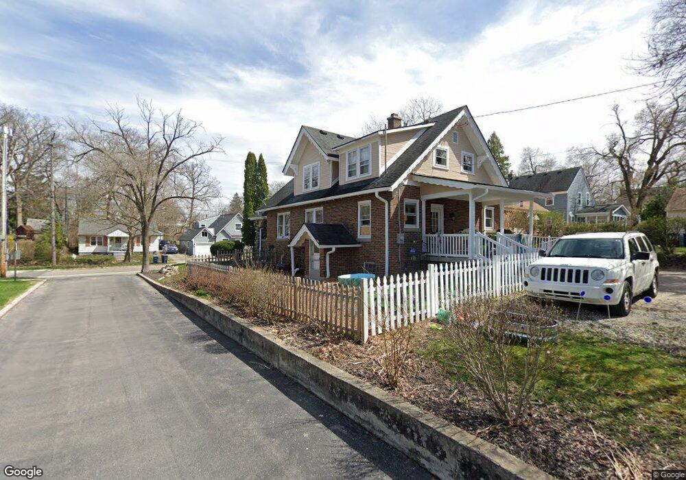
912 S 7th St Ann Arbor, MI 48103
Old West Side NeighborhoodEstimated Value: $562,000 - $731,000
4
Beds
2
Baths
1,729
Sq Ft
$371/Sq Ft
Est. Value
About This Home
This home is located at 912 S 7th St, Ann Arbor, MI 48103 and is currently estimated at $640,632, approximately $370 per square foot. 912 S 7th St is a home located in Washtenaw County with nearby schools including Eberwhite Elementary School, Slauson Middle School, and Pioneer High School.
Ownership History
Date
Name
Owned For
Owner Type
Purchase Details
Closed on
Mar 25, 2025
Sold by
Beal Patrick G and Beal Darlene M
Bought by
Beal Patrick G and Beal Darlene M
Current Estimated Value
Purchase Details
Closed on
Sep 11, 2007
Sold by
Dudley Blair S and Dudley Dianne L
Bought by
Beal Patrick G and Beal Darlene M
Home Financials for this Owner
Home Financials are based on the most recent Mortgage that was taken out on this home.
Original Mortgage
$224,730
Interest Rate
6.71%
Mortgage Type
VA
Purchase Details
Closed on
May 12, 2002
Sold by
Dudley William N
Bought by
Dudley Blair S
Create a Home Valuation Report for This Property
The Home Valuation Report is an in-depth analysis detailing your home's value as well as a comparison with similar homes in the area
Home Values in the Area
Average Home Value in this Area
Purchase History
| Date | Buyer | Sale Price | Title Company |
|---|---|---|---|
| Beal Patrick G | -- | None Listed On Document | |
| Beal Patrick G | -- | None Listed On Document | |
| Beal Patrick G | $220,000 | Ab | |
| Dudley Blair S | -- | -- |
Source: Public Records
Mortgage History
| Date | Status | Borrower | Loan Amount |
|---|---|---|---|
| Previous Owner | Beal Patrick G | $224,730 |
Source: Public Records
Tax History
| Year | Tax Paid | Tax Assessment Tax Assessment Total Assessment is a certain percentage of the fair market value that is determined by local assessors to be the total taxable value of land and additions on the property. | Land | Improvement |
|---|---|---|---|---|
| 2025 | $8,621 | $321,200 | $0 | $0 |
| 2024 | $8,424 | $282,700 | $0 | $0 |
| 2023 | $7,767 | $260,500 | $0 | $0 |
| 2022 | $8,464 | $242,400 | $0 | $0 |
| 2021 | $8,264 | $236,500 | $0 | $0 |
| 2020 | $8,097 | $237,600 | $0 | $0 |
| 2019 | $7,706 | $209,700 | $209,700 | $0 |
| 2018 | $7,598 | $207,200 | $0 | $0 |
| 2017 | $7,391 | $199,500 | $0 | $0 |
| 2016 | $6,295 | $147,790 | $0 | $0 |
| 2015 | $6,790 | $147,348 | $0 | $0 |
| 2014 | $6,790 | $142,745 | $0 | $0 |
| 2013 | -- | $142,745 | $0 | $0 |
Source: Public Records
Map
Nearby Homes
- 912 Hutchins Ave
- 919 5th St
- 1128 Birk Ave
- 1217 Birk Ave
- 1215 Prescott Ave
- 814 W Jefferson St
- 220 W Mosley St
- 401 Berkley Ave
- 636 S Ashley St
- 632 S Ashley St
- 462 W Stadium Blvd
- 450 W Stadium Blvd
- 1347 Arella Blvd
- 1405 W Liberty St
- 1002 W Liberty St
- 717 W Liberty St
- 441 S Ashley St Unit 405
- 140 Ashley Mews Dr Unit 27
- 307 Mulholland Ave
- 430 S Main St
- 918 S 7th St
- 915 S 7th St
- 909 S 7th St
- 920 S 7th St
- 901 W Davis Ave
- 917 S 7th St
- 904 Sunnyside Blvd
- 921 S 7th St
- 906 Sunnyside Blvd
- 809 W Davis Ave
- 923 S 7th St
- 1000 S 7th St
- 908 Sunnyside Blvd
- 1001 S 7th St
- 906 Hutchins Ave
- 908 Hutchins Ave
- 821 S 7th St
- 805 W Davis Ave
- 910 Sunnyside Blvd
- 916 Hutchins Ave
Your Personal Tour Guide
Ask me questions while you tour the home.