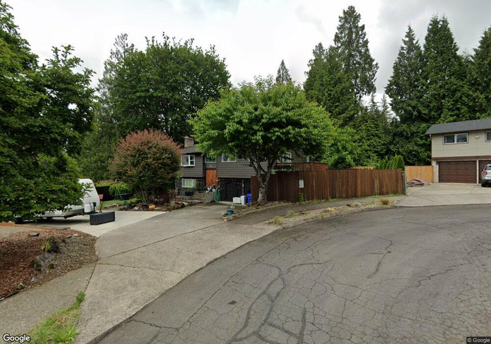
912 SE Phoebe Ct Gresham, OR 97080
Gresham Butte NeighborhoodEstimated Value: $470,000 - $567,000
4
Beds
3
Baths
1,858
Sq Ft
$276/Sq Ft
Est. Value
About This Home
This home is located at 912 SE Phoebe Ct, Gresham, OR 97080 and is currently estimated at $511,932, approximately $275 per square foot. 912 SE Phoebe Ct is a home located in Multnomah County with nearby schools including East Gresham Elementary School, Dexter McCarty Middle School, and Gresham High School.
Ownership History
Date
Name
Owned For
Owner Type
Purchase Details
Closed on
Feb 1, 2013
Sold by
Russell Craig W
Bought by
Camp Faith Myers
Current Estimated Value
Purchase Details
Closed on
Aug 25, 2005
Sold by
Petersen John C
Bought by
Russell Craig W
Home Financials for this Owner
Home Financials are based on the most recent Mortgage that was taken out on this home.
Original Mortgage
$201,200
Interest Rate
6.52%
Mortgage Type
Fannie Mae Freddie Mac
Create a Home Valuation Report for This Property
The Home Valuation Report is an in-depth analysis detailing your home's value as well as a comparison with similar homes in the area
Home Values in the Area
Average Home Value in this Area
Purchase History
| Date | Buyer | Sale Price | Title Company |
|---|---|---|---|
| Camp Faith Myers | $205,000 | First American | |
| Russell Craig W | $251,500 | Pacific Nw Title |
Source: Public Records
Mortgage History
| Date | Status | Borrower | Loan Amount |
|---|---|---|---|
| Previous Owner | Russell Craig W | $201,200 |
Source: Public Records
Tax History
| Year | Tax Paid | Tax Assessment Tax Assessment Total Assessment is a certain percentage of the fair market value that is determined by local assessors to be the total taxable value of land and additions on the property. | Land | Improvement |
|---|---|---|---|---|
| 2025 | $5,436 | $267,120 | -- | -- |
| 2024 | $5,203 | $259,340 | -- | -- |
| 2023 | $4,741 | $251,790 | $0 | $0 |
| 2022 | $4,608 | $244,460 | $0 | $0 |
| 2021 | $4,492 | $237,340 | $0 | $0 |
| 2020 | $4,226 | $230,430 | $0 | $0 |
| 2019 | $4,116 | $223,720 | $0 | $0 |
| 2018 | $3,925 | $217,210 | $0 | $0 |
| 2017 | $3,765 | $210,890 | $0 | $0 |
| 2016 | $3,320 | $204,750 | $0 | $0 |
Source: Public Records
Map
Nearby Homes
- 2581 SE Morlan Way
- 2024 SE Spruce Ave
- 1918 SE Regner Rd
- 2440 SE Regner Rd
- 2909 SE Liberty Place
- 1696 SE 26th Dr
- 2678 SE Myrtlewood Way
- 2925 SE Cleveland Dr
- 242 SE 29th St
- 511 SE 15th St
- 1414 SE Beech Place
- 2125 SE 18th Aly
- 0 SW Miller Ct Unit 470855683
- 2137 SE 15th Aly
- 55 SW Lovhar Dr
- 2240 SE 16th St
- 3544 SE Deer Creek Way
- 2293 SE 15th Aly
- 2392 SE 16th Aly
- 1949 SE Palmquist Rd Unit 51
- 944 SE Phoebe Ct
- 884 SE Phoebe Ct
- 2393 SE Cleveland Ave
- 2333 SE Cleveland Ave
- 2415 SE Cleveland Ave
- 976 SE Phoebe Ct
- 935 SE 25th St
- 863 SE Phoebe Ct
- 846 SE Phoebe Ct
- 903 SE Phoebe Ct
- 828 SE Phoebe Ct
- 831 SE Phoebe Ct
- 929 SE Phoebe Ct
- 863 SE 25th St
- 2243 SE Cleveland Ave
- 819 SE 25th St
- 2258 SE Darling Ave
- 2288 SE Darling Ave
- 1031 SE 23rd Ct
- 2348 SE Darling Ave
Your Personal Tour Guide
Ask me questions while you tour the home.