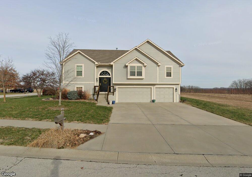
912 W 11th Ave Kearney, MO 64060
Estimated Value: $375,000 - $426,000
3
Beds
3
Baths
1,662
Sq Ft
$235/Sq Ft
Est. Value
About This Home
This home is located at 912 W 11th Ave, Kearney, MO 64060 and is currently estimated at $390,324, approximately $234 per square foot. 912 W 11th Ave is a home located in Clay County with nearby schools including Kearney Junior High School and Kearney High School.
Ownership History
Date
Name
Owned For
Owner Type
Purchase Details
Closed on
Oct 28, 2008
Sold by
Purdy Kerry J and Purdy Debra J
Bought by
Nance Charles and Nance Cynthia
Current Estimated Value
Home Financials for this Owner
Home Financials are based on the most recent Mortgage that was taken out on this home.
Original Mortgage
$175,950
Outstanding Balance
$114,061
Interest Rate
5.83%
Mortgage Type
Purchase Money Mortgage
Estimated Equity
$276,263
Purchase Details
Closed on
Jun 18, 2007
Sold by
Robertson Construction Llc
Bought by
Purdy Debra J and Purdy Kerry J
Home Financials for this Owner
Home Financials are based on the most recent Mortgage that was taken out on this home.
Original Mortgage
$107,500
Interest Rate
6.15%
Mortgage Type
Purchase Money Mortgage
Create a Home Valuation Report for This Property
The Home Valuation Report is an in-depth analysis detailing your home's value as well as a comparison with similar homes in the area
Home Values in the Area
Average Home Value in this Area
Purchase History
| Date | Buyer | Sale Price | Title Company |
|---|---|---|---|
| Nance Charles | -- | Stewart Title Kansas City In | |
| Purdy Debra J | -- | Thomson Title Corp | |
| Robertson Construction Llc | -- | Thomson Title Corporation |
Source: Public Records
Mortgage History
| Date | Status | Borrower | Loan Amount |
|---|---|---|---|
| Open | Nance Charles | $175,950 | |
| Previous Owner | Purdy Debra J | $107,500 |
Source: Public Records
Tax History Compared to Growth
Tax History
| Year | Tax Paid | Tax Assessment Tax Assessment Total Assessment is a certain percentage of the fair market value that is determined by local assessors to be the total taxable value of land and additions on the property. | Land | Improvement |
|---|---|---|---|---|
| 2025 | $3,120 | $50,240 | -- | -- |
| 2024 | $3,120 | $45,520 | -- | -- |
| 2023 | $3,109 | $45,520 | $0 | $0 |
| 2022 | $2,943 | $41,670 | $0 | $0 |
| 2021 | $2,885 | $41,667 | $5,700 | $35,967 |
| 2020 | $2,952 | $38,780 | $0 | $0 |
| 2019 | $2,936 | $38,779 | $5,700 | $33,079 |
| 2018 | $2,774 | $35,380 | $0 | $0 |
| 2017 | $2,744 | $35,380 | $5,320 | $30,060 |
| 2016 | $2,744 | $35,380 | $5,320 | $30,060 |
| 2015 | $2,745 | $35,380 | $5,320 | $30,060 |
| 2014 | $2,758 | $35,380 | $5,320 | $30,060 |
Source: Public Records
Map
Nearby Homes
- 1000 W 10th Ave
- 1004 W 10th Ave
- 1008 W 10th Ave
- 1108 W 10th Ave
- 16411 NE 162nd St
- 972 W Innovation Dr
- 911 Crestridge Dr
- 905 Crestridge Dr
- 606 Briar Ln
- 408 Briar Ln
- 705 Englewood Dr
- 1002 Chisam Rd
- 0 W Washington (Parcel B) St Unit HMS2557812
- 1600 Cottonwood Creek Ct Unit 6
- 1600 Cottonwood Creek Ct Unit 1
- 0 W Washington St
- 1710 Sycamore Ridge
- 608 Woodson St
- Lot 15 Melinda Dr
- Lot 14 Melinda Dr
- 913 W 11th Ave
- 1100 N Sam Barr Dr
- 1102 N Sam Barr Dr
- 1002 W 10th Ave
- 902 N Sam Barr Dr
- 903 N Cypress Cir
- 900 N Sam Barr Dr
- 1006 W 10th Ave
- 915 W 9th Ave
- 806 N Sam Barr Dr
- 901 N Cypress Cir
- 904 N Cypress Cir
- 809 N Cypress Cir
- 804 N Sam Barr Dr
- 914 W 8th Ave
- 912 W 8th Ave
- 910 W 8th Ave
- 916 W 8th Ave
- 807 N Cypress Cir
- 902 N Cypress Cir