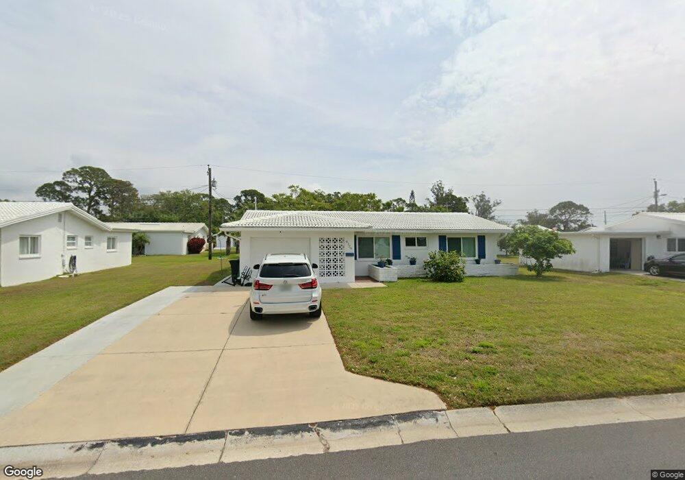
9127 142nd St Seminole, FL 33776
Estimated Value: $424,227 - $508,000
2
Beds
2
Baths
1,642
Sq Ft
$278/Sq Ft
Est. Value
About This Home
This home is located at 9127 142nd St, Seminole, FL 33776 and is currently estimated at $456,307, approximately $277 per square foot. 9127 142nd St is a home located in Pinellas County with nearby schools including Bauder Elementary School, Seminole Middle School, and Seminole High School.
Ownership History
Date
Name
Owned For
Owner Type
Purchase Details
Closed on
Apr 12, 2016
Sold by
Hodges Barbara M
Bought by
Faurot Lois D
Current Estimated Value
Purchase Details
Closed on
Aug 4, 2009
Sold by
Deloach Dennis R
Bought by
Hodges Barbara M
Purchase Details
Closed on
Jul 11, 2003
Sold by
Binnie Carol M
Bought by
Binnie Carol M
Home Financials for this Owner
Home Financials are based on the most recent Mortgage that was taken out on this home.
Original Mortgage
$20,000
Interest Rate
5.94%
Mortgage Type
New Conventional
Purchase Details
Closed on
Feb 8, 2000
Sold by
Binnie Carol M
Bought by
Binnie Carol M
Create a Home Valuation Report for This Property
The Home Valuation Report is an in-depth analysis detailing your home's value as well as a comparison with similar homes in the area
Home Values in the Area
Average Home Value in this Area
Purchase History
| Date | Buyer | Sale Price | Title Company |
|---|---|---|---|
| Faurot Lois D | $233,000 | Fidelity Natl Title Fl Inc | |
| Hodges Barbara M | $200,000 | Seminole Title Company | |
| Binnie Carol M | -- | -- | |
| Binnie Carol M | -- | -- |
Source: Public Records
Mortgage History
| Date | Status | Borrower | Loan Amount |
|---|---|---|---|
| Previous Owner | Binnie Carol M | $20,000 | |
| Previous Owner | Binnie Carol M | $20,000 |
Source: Public Records
Tax History Compared to Growth
Tax History
| Year | Tax Paid | Tax Assessment Tax Assessment Total Assessment is a certain percentage of the fair market value that is determined by local assessors to be the total taxable value of land and additions on the property. | Land | Improvement |
|---|---|---|---|---|
| 2024 | $2,189 | $169,299 | -- | -- |
| 2023 | $2,189 | $164,368 | $0 | $0 |
| 2022 | $2,200 | $159,581 | $0 | $0 |
| 2021 | $2,227 | $154,933 | $0 | $0 |
| 2020 | $2,240 | $152,794 | $0 | $0 |
| 2019 | $2,195 | $149,359 | $0 | $0 |
| 2018 | $2,160 | $146,574 | $0 | $0 |
| 2017 | $2,122 | $142,866 | $0 | $0 |
| 2016 | $1,259 | $98,140 | $0 | $0 |
| 2015 | $1,277 | $97,458 | $0 | $0 |
| 2014 | $1,266 | $96,685 | $0 | $0 |
Source: Public Records
Map
Nearby Homes
- 9156 142nd St
- 9082 141st St
- 14198 89th Ave
- 9234 141st St
- 9024 140th Way
- 9433 Harbor Greens Way Unit 405
- 14157 87th Ave N
- 9450 Harbor Greens Way Unit 503
- 9490 Harbor Greens Way Unit 305
- 9510 Harbor Greens Way Unit 406
- 9000 Commodore Dr Unit 401
- 9000 Commodore Dr Unit 302
- 8755 Commodore Dr
- 9548 141st St
- 14023 94th Place
- 9033 Mission Oaks Blvd Unit 18A
- 13870 Oakwood Ln Unit 13870
- 13829 Mission Oaks Blvd
- 13926 Mission Oaks Blvd Unit 15C
- 9218 Mission Oaks Blvd Unit E