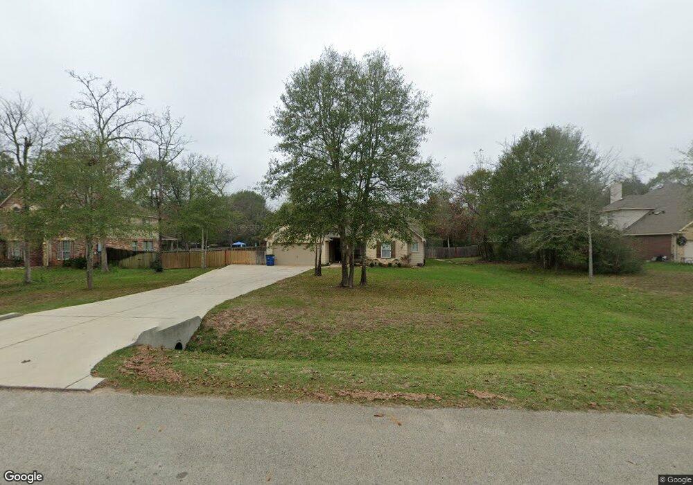
9127 Red Stag Ln Conroe, TX 77303
Estimated Value: $488,000 - $529,000
4
Beds
3
Baths
2,455
Sq Ft
$206/Sq Ft
Est. Value
About This Home
This home is located at 9127 Red Stag Ln, Conroe, TX 77303 and is currently estimated at $504,587, approximately $205 per square foot. 9127 Red Stag Ln is a home located in Montgomery County with nearby schools including Patterson Elementary School, Bozman Intermediate School, and Stockton Junior High School.
Ownership History
Date
Name
Owned For
Owner Type
Purchase Details
Closed on
May 9, 2016
Sold by
Bailey Kristopher Ryan
Bought by
Ladd Ryan S and Ladd Lauren M
Current Estimated Value
Home Financials for this Owner
Home Financials are based on the most recent Mortgage that was taken out on this home.
Original Mortgage
$284,123
Outstanding Balance
$226,549
Interest Rate
3.71%
Mortgage Type
VA
Estimated Equity
$278,038
Purchase Details
Closed on
Mar 26, 2015
Sold by
Khbc Partners Ii
Bought by
Bailey Kristopher Ryan
Home Financials for this Owner
Home Financials are based on the most recent Mortgage that was taken out on this home.
Original Mortgage
$251,740
Interest Rate
3.73%
Mortgage Type
New Conventional
Purchase Details
Closed on
Jul 14, 2014
Sold by
Corley Duane- Trustee
Bought by
Ladd Ryan S and Ladd Lauren M
Create a Home Valuation Report for This Property
The Home Valuation Report is an in-depth analysis detailing your home's value as well as a comparison with similar homes in the area
Home Values in the Area
Average Home Value in this Area
Purchase History
| Date | Buyer | Sale Price | Title Company |
|---|---|---|---|
| Ladd Ryan S | -- | Capital Title | |
| Bailey Kristopher Ryan | -- | None Available | |
| Ladd Ryan S | -- | -- |
Source: Public Records
Mortgage History
| Date | Status | Borrower | Loan Amount |
|---|---|---|---|
| Open | Ladd Ryan S | $284,123 | |
| Previous Owner | Bailey Kristopher Ryan | $251,740 |
Source: Public Records
Tax History
| Year | Tax Paid | Tax Assessment Tax Assessment Total Assessment is a certain percentage of the fair market value that is determined by local assessors to be the total taxable value of land and additions on the property. | Land | Improvement |
|---|---|---|---|---|
| 2025 | $4,931 | $433,688 | -- | -- |
| 2024 | $4,397 | $394,262 | -- | -- |
| 2023 | $4,397 | $358,420 | $58,500 | $378,460 |
| 2022 | $5,676 | $325,840 | $58,500 | $354,460 |
| 2021 | $5,477 | $296,220 | $50,000 | $246,220 |
| 2020 | $6,314 | $324,760 | $15,000 | $309,760 |
| 2019 | $5,982 | $296,960 | $15,000 | $281,960 |
| 2018 | $5,125 | $285,480 | $15,000 | $270,480 |
| 2017 | $5,770 | $285,480 | $15,000 | $270,480 |
| 2016 | $5,452 | $269,790 | $15,000 | $254,790 |
| 2015 | $306 | $15,000 | $15,000 | $0 |
| 2014 | $306 | $15,000 | $15,000 | $0 |
Source: Public Records
Map
Nearby Homes
- 6358 Rolling Hills Rd
- 9115 Bush Buck Ln
- 12371 N Chestnut Hills Dr
- 6248 Rolling Hills Rd
- 6263 Rolling Hills Rd
- 9151 Stonebrooke Chase Dr
- 9155 Stonebrooke Chase Dr
- 9159 Stonebrooke Chase Dr
- 12340 N Chestnut Hills Dr
- 12341 N Chestnut Hills Dr
- 9313 Hard Rock Rd
- 9340 Hard Rock Rd
- 9233 Boulder Blvd
- 6145 White Oak Leaf Loop
- 12859 Lime Stone Ln
- 9025 Water Buck Ln
- 6026 Hazel Place Dr
- 12825 Lime Stone Ln
- 1004 Kelley Rd
- 9436 Hard Rock Rd
- 9131 Red Stag Ln
- 9123 Red Stag Ln
- 9135 Red Stag Ln
- 9119 Red Stag Ln
- 9126 Red Stag Ln
- 9122 Red Stag Ln
- 9139 Red Stag Ln
- 9115 Red Stag Ln
- 9134 Red Stag Ln
- 12424 Red Stag Ct
- 9114 Red Stag Ln
- 12428 Red Stag Ct
- 12438 Red Stag Ct
- 9130 Red Stag Ln
- 9118 Red Stag Ln
- 9111 Red Stag Ln
- 9138 Red Stag Ln
- 9143 Red Stag Ln
- 12420 Red Stag Ct
- 12444 Red Stag Ct
Your Personal Tour Guide
Ask me questions while you tour the home.