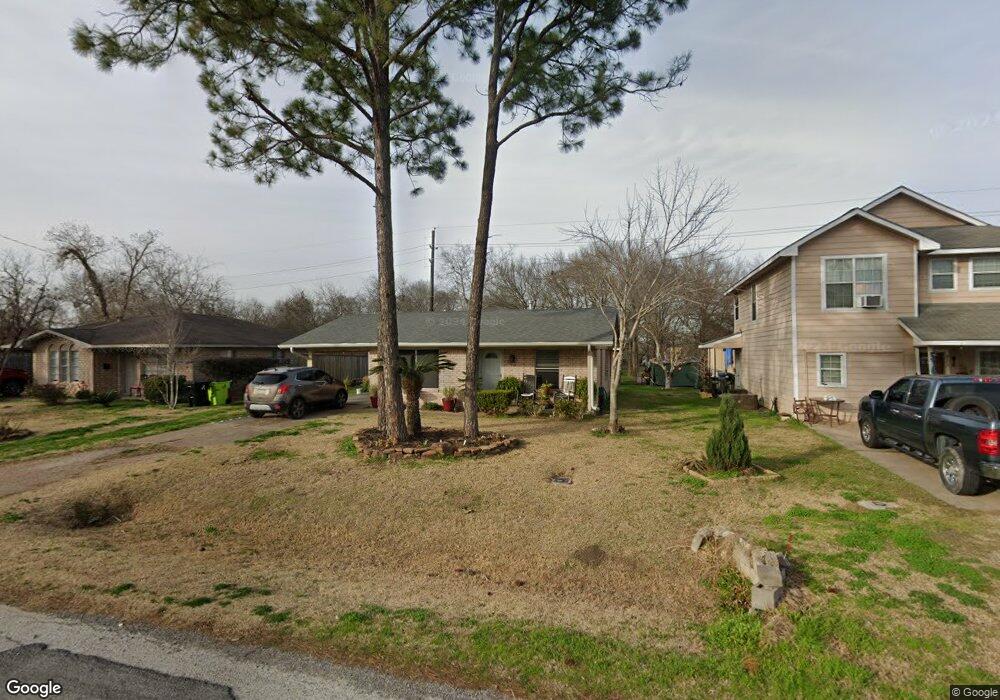
913 Avenue D Rosenberg, TX 77471
Estimated Value: $190,000 - $206,475
3
Beds
2
Baths
1,290
Sq Ft
$152/Sq Ft
Est. Value
About This Home
This home is located at 913 Avenue D, Rosenberg, TX 77471 and is currently estimated at $196,369, approximately $152 per square foot. 913 Avenue D is a home located in Fort Bend County with nearby schools including Travis Elementary School, Henry Wertheimer Middle School, and Briscoe Junior High School.
Ownership History
Date
Name
Owned For
Owner Type
Purchase Details
Closed on
Feb 22, 2006
Sold by
Mclean Kyle and Mclean Nichola
Bought by
Lasso Mayo
Current Estimated Value
Home Financials for this Owner
Home Financials are based on the most recent Mortgage that was taken out on this home.
Original Mortgage
$85,000
Outstanding Balance
$47,568
Interest Rate
6.1%
Mortgage Type
Fannie Mae Freddie Mac
Estimated Equity
$148,801
Purchase Details
Closed on
Nov 12, 1999
Sold by
Smith Doris Galloway
Bought by
Mclean Kyle and Mclean Nichola
Create a Home Valuation Report for This Property
The Home Valuation Report is an in-depth analysis detailing your home's value as well as a comparison with similar homes in the area
Home Values in the Area
Average Home Value in this Area
Purchase History
| Date | Buyer | Sale Price | Title Company |
|---|---|---|---|
| Lasso Mayo | -- | Stewart Title Fort Bend Div | |
| Jasso Mayo | -- | -- | |
| Mclean Kyle | -- | Startex Title |
Source: Public Records
Mortgage History
| Date | Status | Borrower | Loan Amount |
|---|---|---|---|
| Open | Jasso Mayo | $85,000 |
Source: Public Records
Tax History Compared to Growth
Tax History
| Year | Tax Paid | Tax Assessment Tax Assessment Total Assessment is a certain percentage of the fair market value that is determined by local assessors to be the total taxable value of land and additions on the property. | Land | Improvement |
|---|---|---|---|---|
| 2025 | $780 | $212,900 | $49,500 | $163,400 |
| 2024 | $780 | $221,817 | $48,591 | $173,226 |
| 2023 | $724 | $201,652 | $23,012 | $178,640 |
| 2022 | $1,899 | $183,320 | $45,210 | $138,110 |
| 2021 | $3,458 | $166,650 | $63,360 | $103,290 |
| 2020 | $3,564 | $167,940 | $63,360 | $104,580 |
| 2019 | $2,710 | $118,640 | $20,060 | $98,580 |
| 2018 | $1,424 | $61,370 | $20,060 | $41,310 |
| 2017 | $1,398 | $59,880 | $20,060 | $39,820 |
| 2016 | $1,367 | $58,580 | $20,060 | $38,520 |
| 2015 | $1,404 | $59,850 | $20,060 | $39,790 |
| 2014 | $1,440 | $60,630 | $20,060 | $40,570 |
Source: Public Records
Map
Nearby Homes
- 915 Avenue E
- 503 Willow St
- 735 Willow St
- 428 West St
- 1210 Avenue E
- 00000 Baker Rd
- 1605 Walnut Ave
- 1112 James St
- 805 Avenue J
- 613 Baker Rd
- 3326 Tilley Dr
- 401 2nd St
- 413 2nd St
- 2519 Good Morrow Dr
- 5534 Handlewood Ln
- 2606 Good Morrow Dr
- 2630 Wastelbread Ln
- 2619 Wastelbread Ln
- 2515 Good Morrow Dr
- 2618 Wastelbread Ln