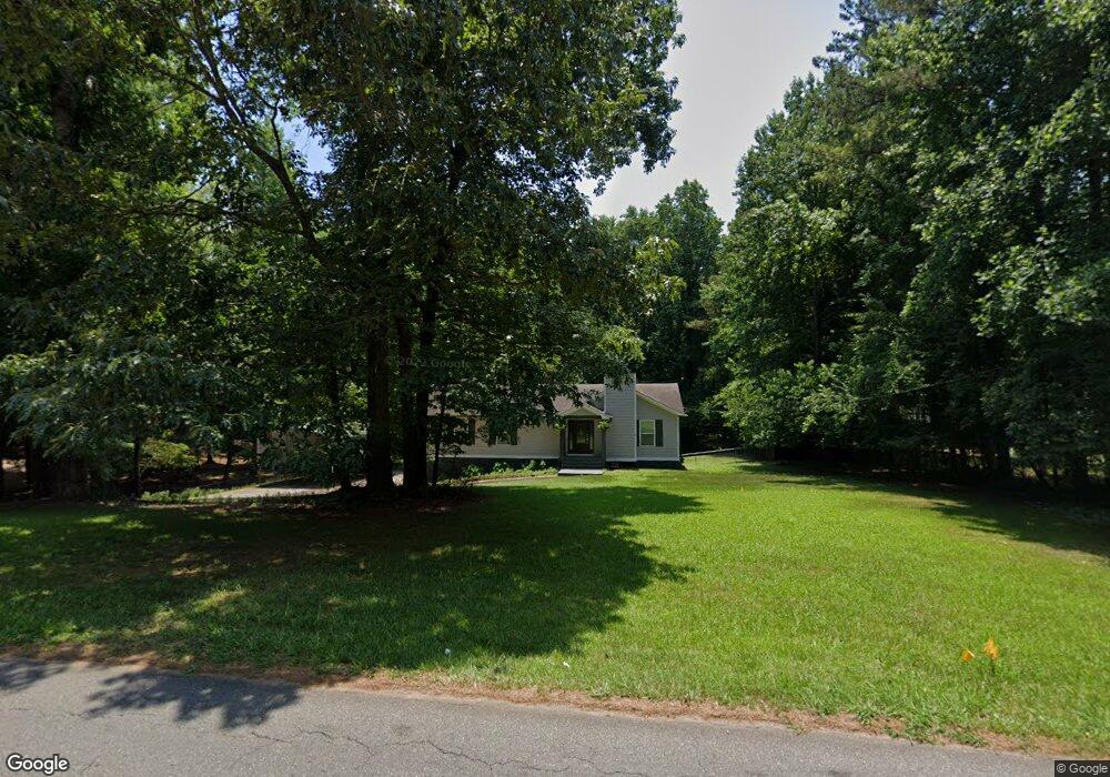
913 Victoria Landing Dr Woodstock, GA 30189
Sutallee NeighborhoodEstimated Value: $347,000 - $501,000
3
Beds
2
Baths
1,568
Sq Ft
$256/Sq Ft
Est. Value
About This Home
This home is located at 913 Victoria Landing Dr, Woodstock, GA 30189 and is currently estimated at $401,469, approximately $256 per square foot. 913 Victoria Landing Dr is a home located in Cherokee County with nearby schools including Boston Elementary School, E. T. Booth Middle School, and Etowah High School.
Ownership History
Date
Name
Owned For
Owner Type
Purchase Details
Closed on
Apr 30, 2020
Sold by
Lewis Molly Sue
Bought by
Meyer Audrey
Current Estimated Value
Purchase Details
Closed on
Apr 28, 2020
Sold by
Rubert Julius L
Bought by
Meyer Audrey
Purchase Details
Closed on
Aug 26, 1994
Sold by
Heriot George Patricia
Bought by
Rubert Julius Beverly
Home Financials for this Owner
Home Financials are based on the most recent Mortgage that was taken out on this home.
Original Mortgage
$77,050
Interest Rate
6.5%
Mortgage Type
Assumption
Create a Home Valuation Report for This Property
The Home Valuation Report is an in-depth analysis detailing your home's value as well as a comparison with similar homes in the area
Home Values in the Area
Average Home Value in this Area
Purchase History
| Date | Buyer | Sale Price | Title Company |
|---|---|---|---|
| Meyer Audrey | -- | -- | |
| Meyer Audrey | -- | -- | |
| Rubert Julius Beverly | $1,000 | -- |
Source: Public Records
Mortgage History
| Date | Status | Borrower | Loan Amount |
|---|---|---|---|
| Previous Owner | Rubert Julius Beverly | $77,050 |
Source: Public Records
Tax History Compared to Growth
Tax History
| Year | Tax Paid | Tax Assessment Tax Assessment Total Assessment is a certain percentage of the fair market value that is determined by local assessors to be the total taxable value of land and additions on the property. | Land | Improvement |
|---|---|---|---|---|
| 2024 | $3,292 | $126,692 | $29,200 | $97,492 |
| 2023 | $3,360 | $129,292 | $29,200 | $100,092 |
| 2022 | $2,889 | $109,932 | $25,200 | $84,732 |
| 2021 | $2,592 | $91,292 | $21,040 | $70,252 |
| 2020 | $2,349 | $82,652 | $18,800 | $63,852 |
| 2019 | $1,955 | $68,800 | $16,200 | $52,600 |
| 2018 | $1,865 | $65,240 | $14,800 | $50,440 |
| 2017 | $1,819 | $163,300 | $14,800 | $50,520 |
| 2016 | $1,819 | $156,200 | $13,600 | $48,880 |
| 2015 | $1,636 | $139,100 | $13,600 | $42,040 |
| 2014 | $1,357 | $115,200 | $11,080 | $35,000 |
Source: Public Records
Map
Nearby Homes
- 314 Bethel Dr
- 504 N Little Victoria Rd
- 819 Victoria Place
- 619 Lovinggood Trail
- 609 Redwood Dr
- 477 Victoria Rd
- 923 Pine Cir
- 617 Driftwood Dr
- 401 Cottonwood Dr
- 313 Maltibe Dr
- 308 Mainsail Ln
- 0 Black Oak Trail Unit 10267626
- 0 Black Oak Trail Unit 7303191
- 306 N Briar Ridge
- 912 Oak Dr
- 146 Sunset Ln
- 204 Captains Quarters
- 7119 Big Woods Dr
- 507 Huntgate Rd
- 915 Victoria Landing Dr
- 911 Victoria Landing Dr
- 7 Emerald Cove Dr
- 916 Victoria Landing Dr
- 219 Emerald Cove Ln
- 0 Emerald Cove Ln Unit 7288439
- 0 Emerald Cove Ln
- 909 Victoria Landing Dr
- 917 Victoria Landing Dr
- 914 Victoria Landing Dr Unit 914
- 914 Victoria Landing Dr
- 918 Victoria Landing Dr
- 221 Emerald Cove Ln
- 920 Victoria Landing Dr
- 912 Victoria Landing Dr
- 217 Emerald Cove Ln
- 907 Victoria Landing Dr
- 223 Emerald Cove Ln
- 910 Victoria Landing Dr
- 919 Victoria Landing Dr