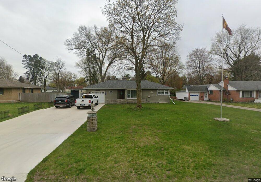
913 Wendover Blvd Norton Shores, MI 49441
Estimated Value: $231,397 - $258,000
2
Beds
2
Baths
1,134
Sq Ft
$217/Sq Ft
Est. Value
About This Home
This home is located at 913 Wendover Blvd, Norton Shores, MI 49441 and is currently estimated at $246,599, approximately $217 per square foot. 913 Wendover Blvd is a home located in Muskegon County with nearby schools including Mona Shores High School, Edgewood Elementary Academy, and Dr. Martin Luther King Academy.
Ownership History
Date
Name
Owned For
Owner Type
Purchase Details
Closed on
Aug 15, 2008
Sold by
Muttart Bonnie M and Kwolek Carol
Bought by
Grant Robert T
Current Estimated Value
Home Financials for this Owner
Home Financials are based on the most recent Mortgage that was taken out on this home.
Original Mortgage
$105,214
Outstanding Balance
$69,359
Interest Rate
6.42%
Mortgage Type
VA
Estimated Equity
$177,240
Purchase Details
Closed on
Nov 7, 1996
Sold by
Gundy Kenneth E and Gundy Violet M
Bought by
Berg Bonnie and Kwolek Carol
Create a Home Valuation Report for This Property
The Home Valuation Report is an in-depth analysis detailing your home's value as well as a comparison with similar homes in the area
Home Values in the Area
Average Home Value in this Area
Purchase History
| Date | Buyer | Sale Price | Title Company |
|---|---|---|---|
| Grant Robert T | $103,000 | Harbor Title | |
| Berg Bonnie | -- | None Available |
Source: Public Records
Mortgage History
| Date | Status | Borrower | Loan Amount |
|---|---|---|---|
| Open | Grant Robert T | $105,214 |
Source: Public Records
Tax History Compared to Growth
Tax History
| Year | Tax Paid | Tax Assessment Tax Assessment Total Assessment is a certain percentage of the fair market value that is determined by local assessors to be the total taxable value of land and additions on the property. | Land | Improvement |
|---|---|---|---|---|
| 2025 | -- | $108,600 | $0 | $0 |
| 2024 | -- | $94,900 | $0 | $0 |
| 2023 | -- | $0 | $0 | $0 |
| 2022 | $0 | $0 | $0 | $0 |
| 2021 | $0 | $0 | $0 | $0 |
| 2020 | $0 | $0 | $0 | $0 |
| 2019 | $1,384 | $54,000 | $0 | $0 |
| 2018 | $1,731 | $48,700 | $0 | $0 |
| 2017 | $1,691 | $48,700 | $0 | $0 |
| 2016 | $1,310 | $45,400 | $0 | $0 |
| 2015 | -- | $44,100 | $0 | $0 |
| 2014 | $1,571 | $42,400 | $0 | $0 |
| 2013 | -- | $41,000 | $0 | $0 |
Source: Public Records
Map
Nearby Homes
- 1068 Englewood Ave
- 4102 Highgate Rd
- 1130 Englewood Ave
- 945 Petrie Ave
- 1201 Shettler Rd
- 4468 Spruce Ct
- 1067 Aspen Dr
- 3920 Highgate Rd
- 4476 Cedar Ln Unit 54
- V/L 4535 Thompson Rd
- 4060 Buck St
- 1065 Wilson Ct
- 4535 Thompson Rd
- 4638 Lauren Dr
- 1454 Airport Rd
- 4085 Quainton Rd
- 3835 Molly Blvd
- 4677 Harvey St
- 1071 Calgary Dr
- 4875 Paul Ct
- 903 Wendover Blvd
- 925 Wendover Blvd
- 914 Airport Rd
- 895 Wendover Blvd
- 902 Airport Rd
- 926 Airport Rd
- 886 Airport Rd
- 875 Wendover Blvd
- 945 Wendover Blvd
- 912 Wendover Blvd
- 924 Wendover Blvd
- 876 Airport Rd
- 900 Wendover Blvd
- 938 Airport Rd
- 888 Wendover Blvd
- 909 Airport Rd
- 948 Airport Rd
- 866 Airport Rd
- 948 Wendover Blvd
- 927 Airport Rd