Estimated Value: $474,000 - $487,306
3
Beds
2
Baths
2,299
Sq Ft
$209/Sq Ft
Est. Value
About This Home
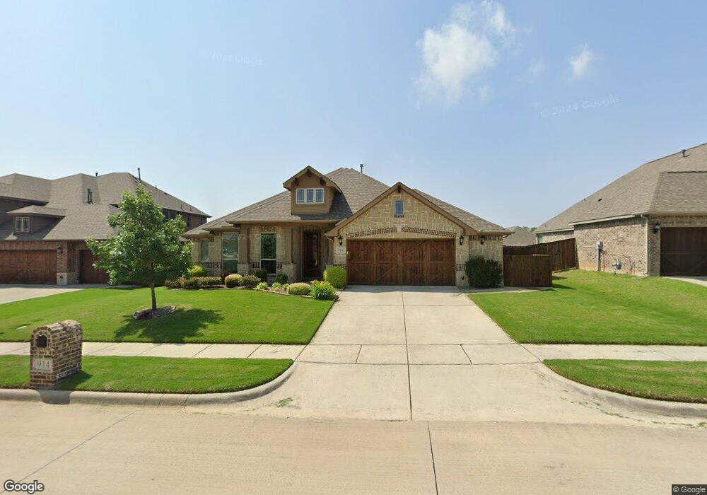
This home is located at 914 Birchwood Dr, Wylie, TX 75098 and is currently estimated at $480,327, approximately $208 per square foot. 914 Birchwood Dr is a home located in Collin County with nearby schools including P M Akin Elementary School, AB Harrison Intermediate School, and Grady Burnett J High School.
Ownership History
Date
Name
Owned For
Owner Type
Purchase Details
Closed on
Mar 29, 2017
Sold by
Bloomfifed Homes Lp
Bought by
Jeffers William B and Jeffers Janet C
Current Estimated Value
Home Financials for this Owner
Home Financials are based on the most recent Mortgage that was taken out on this home.
Original Mortgage
$317,011
Outstanding Balance
$263,366
Interest Rate
4.15%
Mortgage Type
VA
Estimated Equity
$216,961
Create a Home Valuation Report for This Property
The Home Valuation Report is an in-depth analysis detailing your home's value as well as a comparison with similar homes in the area
Home Values in the Area
Average Home Value in this Area
Purchase History
| Date | Buyer | Sale Price | Title Company |
|---|---|---|---|
| Jeffers William B | -- | None Available |
Source: Public Records
Mortgage History
| Date | Status | Borrower | Loan Amount |
|---|---|---|---|
| Open | Jeffers William B | $317,011 |
Source: Public Records
Tax History Compared to Growth
Tax History
| Year | Tax Paid | Tax Assessment Tax Assessment Total Assessment is a certain percentage of the fair market value that is determined by local assessors to be the total taxable value of land and additions on the property. | Land | Improvement |
|---|---|---|---|---|
| 2025 | $4,836 | $480,244 | $130,000 | $351,692 |
| 2024 | $4,836 | $436,585 | $130,000 | $354,647 |
| 2023 | $4,836 | $396,895 | $110,000 | $363,290 |
| 2022 | $7,916 | $360,814 | $110,000 | $314,196 |
| 2021 | $7,718 | $328,013 | $80,000 | $248,013 |
| 2020 | $7,545 | $303,866 | $80,000 | $223,866 |
| 2019 | $8,306 | $316,070 | $80,000 | $236,070 |
| 2018 | $8,377 | $311,057 | $80,000 | $231,057 |
| 2017 | $4,596 | $170,674 | $63,200 | $107,474 |
| 2016 | $1,537 | $55,320 | $55,320 | $0 |
Source: Public Records
Map
Nearby Homes
- 304 Hawthorn Dr
- 310 Hawthorn Dr
- 114 Liberty Dr
- 207 Spence Dr
- 409 Cedar Ridge Dr
- 213 N West A Allen Blvd
- 216 Cedar Ridge St
- 104 Rushcreek Dr
- 825 Foxwood Ln
- 1056 Fairview Dr
- 820 Foxwood Ln
- 104 N 5th St
- 1209 Surrey Cir
- 825 Forest Edge Ln
- 811 Forest Edge Ln
- 107 Windy Knoll Ln
- 306 Foxwood Ct
- 306 Woodhollow Ct
- 300 Woodhollow Ct
- 1022 Debby Ct
- 912 Birchwood Dr
- 916 Birchwood Dr
- 915 Redwood Ct
- 910 Birchwood Dr
- 917 Redwood Ct
- 913 Redwood Ct
- 303 Birchwood Dr
- 300 Hawthorn Dr
- 919 Redwood Ct
- 911 Redwood Ct
- 915 Birchwood Dr
- 908 Birchwood Dr
- 302 Hawthorn Dr
- 913 Birchwood Dr
- 305 Hawthorn Dr
- 909 Redwood Ct
- 921 Redwood Ct
- 906 Birchwood Dr
- 911 Birchwood Dr
- 914 Redwood Ct