Estimated Value: $337,371 - $371,000
3
Beds
2
Baths
3,065
Sq Ft
$117/Sq Ft
Est. Value
About This Home
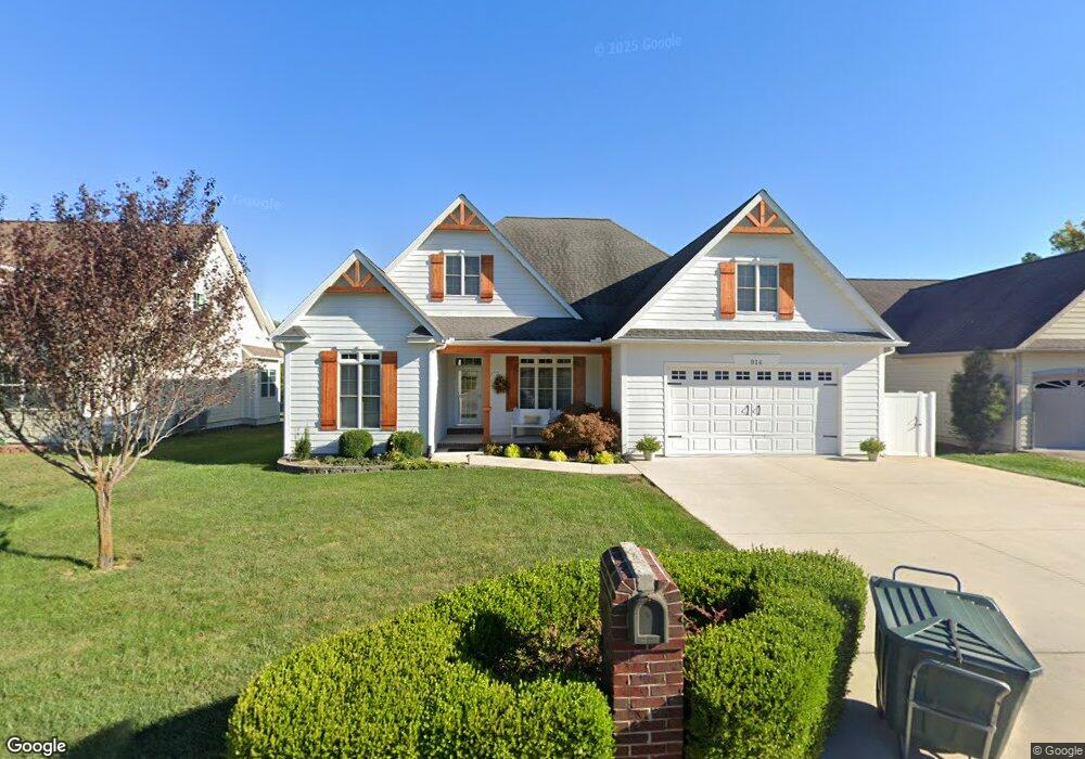
This home is located at 914 Brookside Dr, Rolla, MO 65401 and is currently estimated at $358,457, approximately $116 per square foot. 914 Brookside Dr is a home located in Phelps County with nearby schools including Rolla Junior High School, Rolla Senior High School, and Rolla Seventh-Day Adventist School.
Ownership History
Date
Name
Owned For
Owner Type
Purchase Details
Closed on
Sep 30, 2020
Bought by
Treece Troy E and Treece Marcella A
Current Estimated Value
Purchase Details
Closed on
Nov 26, 2013
Purchase Details
Closed on
Oct 26, 2012
Purchase Details
Closed on
May 21, 2008
Purchase Details
Closed on
Feb 28, 2006
Purchase Details
Closed on
Jan 29, 1998
Create a Home Valuation Report for This Property
The Home Valuation Report is an in-depth analysis detailing your home's value as well as a comparison with similar homes in the area
Home Values in the Area
Average Home Value in this Area
Purchase History
| Date | Buyer | Sale Price | Title Company |
|---|---|---|---|
| Treece Troy E | $240,000 | -- | |
| -- | $187,000 | -- | |
| -- | -- | -- | |
| -- | -- | -- | |
| -- | -- | -- | |
| -- | -- | -- |
Source: Public Records
Tax History
| Year | Tax Paid | Tax Assessment Tax Assessment Total Assessment is a certain percentage of the fair market value that is determined by local assessors to be the total taxable value of land and additions on the property. | Land | Improvement |
|---|---|---|---|---|
| 2025 | $2,319 | $44,440 | $5,700 | $38,740 |
| 2024 | $2,113 | $39,310 | $4,090 | $35,220 |
| 2023 | $2,127 | $39,310 | $4,090 | $35,220 |
| 2022 | $1,806 | $39,310 | $4,090 | $35,220 |
| 2021 | $1,818 | $39,310 | $4,090 | $35,220 |
| 2020 | $1,646 | $34,710 | $4,090 | $30,620 |
| 2019 | $1,636 | $34,710 | $4,090 | $30,620 |
| 2018 | $1,622 | $34,710 | $4,090 | $30,620 |
| 2017 | $1,619 | $34,710 | $4,090 | $30,620 |
| 2016 | $1,556 | $34,490 | $4,090 | $30,400 |
| 2015 | -- | $34,490 | $4,090 | $30,400 |
| 2014 | -- | $34,490 | $4,090 | $30,400 |
| 2013 | -- | $34,490 | $0 | $0 |
Source: Public Records
Map
Nearby Homes
- 1011 Carriage Ln
- 909 Cypress Dr
- 495 Countryside Dr
- Lot 74 B Cedar Hill Ct
- Lot 74 A Cedar Hill Ct
- 1102 Sycamore Dr
- 1331 Highway O
- 18119 State Route O
- 821 Highway O
- 807 Lariat Ln
- 816 Laurel Dr
- 509 Oak Knoll Rd
- 210 Becca Dr
- 1221 Casey Ln
- 5 acres W Lions Club Dr
- 821 Cambridge Dr
- 200 Brady Dr
- 503 Lariat Ln
- 45 Mcfarland Dr
- TBD Shady Ln
- 914 Brookside Ln
- 910 Brookside Dr
- 918 Brookside Ln
- 927 Brookside Ln
- 11 Brookside Ln
- 18 Brookside Ln
- 20 Brookside Ln
- 922 Brookside Dr
- 0 Cottage Ct Unit 109052
- 908 Brookside Dr
- 924 Brookside Dr
- 907 Cottage Ct
- 906 Brookside Dr
- 0 927 and 929 Brookside Ln Unit 19083083
- 0 927 and 929 Brookside Ln Unit 19028338
- 926 Brookside Ln
- 919 Cottage Ct
- 905 Brookside Dr
- 905 Brookside Ln
- 923 Brookside Dr
Your Personal Tour Guide
Ask me questions while you tour the home.