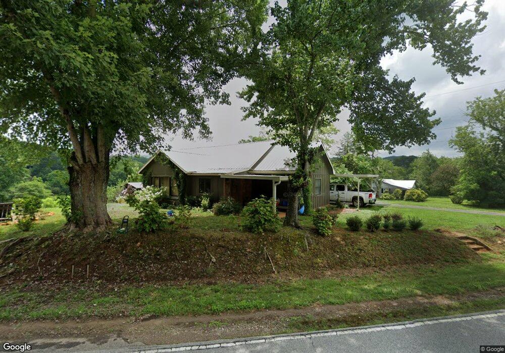
914 Sanderstown Rd Franklin, NC 28734
Estimated Value: $121,000 - $254,000
3
Beds
1
Bath
1,144
Sq Ft
$185/Sq Ft
Est. Value
About This Home
This home is located at 914 Sanderstown Rd, Franklin, NC 28734 and is currently estimated at $211,761, approximately $185 per square foot. 914 Sanderstown Rd is a home located in Macon County with nearby schools including Iotla Valley Elementary School, Macon Middle School, and Mountain View Intermediate School.
Ownership History
Date
Name
Owned For
Owner Type
Purchase Details
Closed on
May 1, 2025
Sold by
Shook Albert and Shook Patricia Ann
Bought by
Dalton Lauren Ky and Bichard Joseph Adam
Current Estimated Value
Home Financials for this Owner
Home Financials are based on the most recent Mortgage that was taken out on this home.
Original Mortgage
$74,920
Outstanding Balance
$73,080
Interest Rate
6.67%
Mortgage Type
Seller Take Back
Estimated Equity
$138,681
Purchase Details
Closed on
Jan 12, 2011
Sold by
Shuford Shuford James E James E
Bought by
Shook Albert and Shook Patricia Ann
Home Financials for this Owner
Home Financials are based on the most recent Mortgage that was taken out on this home.
Original Mortgage
$87,500
Interest Rate
4.58%
Mortgage Type
Purchase Money Mortgage
Create a Home Valuation Report for This Property
The Home Valuation Report is an in-depth analysis detailing your home's value as well as a comparison with similar homes in the area
Home Values in the Area
Average Home Value in this Area
Purchase History
| Date | Buyer | Sale Price | Title Company |
|---|---|---|---|
| Dalton Lauren Ky | $120,000 | None Listed On Document | |
| Dalton Lauren Ky | $120,000 | None Listed On Document | |
| Shook Albert | $88,000 | None Available |
Source: Public Records
Mortgage History
| Date | Status | Borrower | Loan Amount |
|---|---|---|---|
| Open | Dalton Lauren Ky | $74,920 | |
| Closed | Dalton Lauren Ky | $74,920 | |
| Previous Owner | Shook Albert | $87,500 |
Source: Public Records
Tax History
| Year | Tax Paid | Tax Assessment Tax Assessment Total Assessment is a certain percentage of the fair market value that is determined by local assessors to be the total taxable value of land and additions on the property. | Land | Improvement |
|---|---|---|---|---|
| 2025 | $622 | $147,130 | $47,110 | $100,020 |
| 2024 | $622 | $147,130 | $47,110 | $100,020 |
| 2023 | $543 | $147,130 | $47,110 | $100,020 |
| 2022 | $543 | $91,650 | $24,470 | $67,180 |
| 2021 | $412 | $66,780 | $24,470 | $42,310 |
| 2020 | $395 | $66,780 | $24,470 | $42,310 |
| 2018 | $398 | $75,140 | $24,470 | $50,670 |
| 2017 | $398 | $75,140 | $24,470 | $50,670 |
| 2016 | $391 | $75,140 | $24,470 | $50,670 |
| 2015 | $368 | $75,140 | $24,470 | $50,670 |
| 2014 | $370 | $96,570 | $32,250 | $64,320 |
| 2013 | -- | $96,570 | $32,250 | $64,320 |
Source: Public Records
Map
Nearby Homes
- 110 Bailey Hills Rd
- 177 Bailey Hills Rd
- 102 Garnett Trace Rd
- 314 McDonald Rd
- 530 Mane Loop Rd
- Lot 40 Buck Mountain Rd
- 134 Sunset View Trail
- Lot 31 Lyle Knob Rd
- 158 Sunset View Trail
- 158 Sunset View Trail Unit 254
- 172 Sunset View Trail
- 307 Sunset View Trail
- 289 Sunset View Trail
- 00 Lyle Knob
- 1860 Lyle Knob Rd
- 2712 Lyle Knob Rd
- 567 Clyde Downs Rd
- Lot 4 Brendle Rd
- Lot 6 Brendle Rd
- Lot 5 Brendle Rd
- 950 Sanderstown Rd
- 12 Ruby Holland Rd
- 45 Ruby Holland Rd
- 975 Sanderstown Rd
- 248 Poverty Branch Dr
- 82 Poverty Branch Dr
- 00 Poverty Branch Dr
- 1002 Sanderstown Rd
- 74 Ruby Holland Rd
- 295 Poverty Branch Dr
- 42 Old Barn Dr
- 180 Lori Hill Rd
- Lot 19 Buck Mountain Estate
- 107 Lorihill Rd
- 1135 Sanderstown Rd
- 0 Ruby Holland Rd
- Lot 15 Buck Mountain Estate
- 21 Old Barn Dr
- 294 Ruby Holland Rd
- 72 Old Barn Dr
Your Personal Tour Guide
Ask me questions while you tour the home.