


914 W Bogart Rd Sandusky, OH 44870
Estimated payment $2,666/month
Total Views
31,735
4
Beds
3.5
Baths
2,856
Sq Ft
$151
Price per Sq Ft
Highlights
- Hot Property
- Formal Dining Room
- Living Room
- 0.84 Acre Lot
- 2.5 Car Direct Access Garage
- Laundry Room
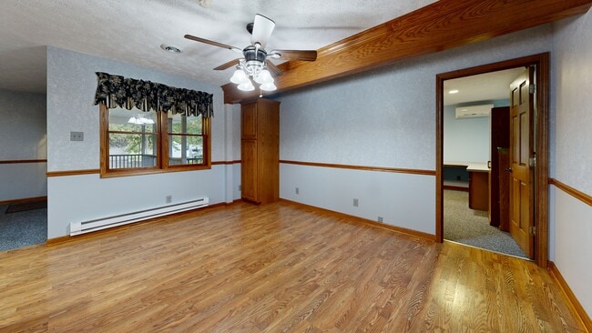
About This Home
Welcome to this surprisingly spacious home featuring an impressive 42 x 50 outbuilding that's heated and air-conditioned perfect for workshop, or storage for cars and boats. The possibilities are endless! This home offers approximately 2,856 square feet with four bedrooms and three and a half baths. Thoughtfully updated over the years by the original owner, it includes many remodels and additions. Enjoy relaxing on the lovely front porch before stepping into the inviting entry foyer and spacious family room, complete with a gas log stone fireplace that can also be wood-burning. The huge kitchen boasts over 40 cabinets, a large pantry, and a full appliance package ideal for any home chef. The dining and gathering rooms provide the perfect space for entertaining, and there's also a home office with a separate entrance, great for anyone running a business from home. Upstairs, you'll find a newly renovated master suite with a large bath, laundry area, and a private deck off the bathroom. The second floor offers three additional bedrooms and two baths, making it perfect for a junior suite or guest accommodations. Recent updates include a furnace and A/C that are three years old, a tankless water heater, 200-amp electric service, a new thermostat, and a sump pump that's just one month old. The basement provides excellent storage, plus an extra washer and dryer. Outside, you'll love the huge covered deck, 2.5-car attached garage, and an attached shed for additional storage. And as a unique bonus NASA is your backyard neighbor!
Co-Listing Agent
Default zSystem
zSystem Default
Home Details
Home Type
- Single Family
Est. Annual Taxes
- $4,840
Year Built
- Built in 1976
Lot Details
- 0.84 Acre Lot
Parking
- 2.5 Car Direct Access Garage
- Garage Door Opener
- Open Parking
Home Design
- Asphalt Roof
- Vinyl Siding
Interior Spaces
- 2,856 Sq Ft Home
- 1.5-Story Property
- Ceiling Fan
- Gas Fireplace
- Entrance Foyer
- Family Room
- Living Room
- Formal Dining Room
Kitchen
- Cooktop
- Microwave
- Dishwasher
- Disposal
Bedrooms and Bathrooms
- 4 Bedrooms
- Primary bedroom located on second floor
Laundry
- Laundry Room
- Dryer
- Washer
Basement
- Partial Basement
- Laundry in Basement
Utilities
- Forced Air Heating and Cooling System
- Heating System Uses Natural Gas
- 200+ Amp Service
- Cable TV Available
Listing and Financial Details
- Home warranty included in the sale of the property
- Assessor Parcel Number 3202588.000
Matterport 3D Tour
Floorplans
Map
Create a Home Valuation Report for This Property
The Home Valuation Report is an in-depth analysis detailing your home's value as well as a comparison with similar homes in the area
Home Values in the Area
Average Home Value in this Area
Tax History
| Year | Tax Paid | Tax Assessment Tax Assessment Total Assessment is a certain percentage of the fair market value that is determined by local assessors to be the total taxable value of land and additions on the property. | Land | Improvement |
|---|---|---|---|---|
| 2024 | $4,842 | $105,773 | $15,512 | $90,261 |
| 2023 | $4,842 | $102,515 | $12,817 | $89,698 |
| 2022 | $5,758 | $102,515 | $12,817 | $89,698 |
| 2021 | $5,751 | $102,520 | $12,820 | $89,700 |
| 2020 | $4,335 | $77,920 | $12,820 | $65,100 |
| 2019 | $4,460 | $77,920 | $12,820 | $65,100 |
| 2018 | $4,463 | $77,920 | $12,820 | $65,100 |
| 2017 | $4,469 | $75,920 | $13,940 | $61,980 |
| 2016 | $3,903 | $75,920 | $13,940 | $61,980 |
| 2015 | $3,833 | $75,920 | $13,940 | $61,980 |
| 2014 | $4,025 | $78,880 | $13,940 | $64,940 |
| 2013 | $3,753 | $78,880 | $13,940 | $64,940 |
Source: Public Records
Property History
| Date | Event | Price | List to Sale | Price per Sq Ft |
|---|---|---|---|---|
| 11/10/2025 11/10/25 | Price Changed | $429,900 | -4.4% | $151 / Sq Ft |
| 10/20/2025 10/20/25 | For Sale | $449,900 | -- | $158 / Sq Ft |
Source: Firelands Association of REALTORS®
Purchase History
| Date | Type | Sale Price | Title Company |
|---|---|---|---|
| Deed | -- | -- |
Source: Public Records
About the Listing Agent
Meet Linda Armstrong & The A Team — Your Trusted Real Estate Experts
At Linda Armstrong & The A Team, we believe that real estate is more than just transactions — it’s about people, relationships, and helping clients navigate one of the biggest decisions of their lives with confidence and care. Backed by decades of experience, a deep knowledge of the local market, and a passion for service, The A Team brings together a group of dedicated professionals who are committed to delivering results.
Linda's Other Listings
Source: Firelands Association of REALTORS®
MLS Number: 20254191
APN: 32-02588-000
Nearby Homes
- 1006 W Bogart Rd
- 1101 W Bogart Rd
- 1305 S Lake Wilmer Dr Unit 207
- 1305 S Lake Wilmer Dr Unit 208A
- 405 Birchwood Dr
- 4913 Lisbon Cir
- 4904 Lisbon Cir
- 3719 Hoffman Dr
- 3810 Didion Dr
- 0 Us Rte 250 Unit 5105465
- 0 Us Rte 250 Unit 20250774
- 0 Us Rte 250 Unit 9066254
- 611 E Bogart Rd
- 0 Crossings Rd Unit 20213052
- 0 Crossings Rd Unit 20213054
- 6291 Zachary Ln
- 38 Zachary Ln
- 21 Zachary Ln
- 32 Zachary Ln
- 40 Zachary Ln
- 1196 Walt Lake Trail Unit Lake Point 3 Condos
- 1305 S Lake Wilmer Dr Unit 102A
- 3307 Columbus Ave
- 1600 Pelton Park Dr
- 100 Brook Blvd
- 2613 Pioneer Trail
- 122 Redwood Dr
- 2800 Mall Dr N
- 3912 Coventry Ln
- 1211 Wamajo Dr
- 1227 Avondale St
- 1511 Columbus Ave Unit C
- 1632 Oakmont Ln
- 1603 Shelby St
- 22 Marina Point Dr
- 1528 5th St Unit Green
- 1528 5th St Unit Purple
- 1528 5th St Unit Blue
- 1309 Stone St
- 1032 Perry St