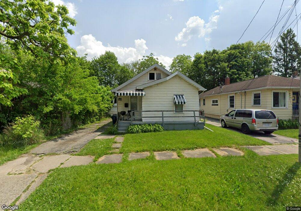
915 Hughes Ave Flint, MI 48503
Mannhall Park NeighborhoodEstimated Value: $39,000 - $48,363
3
Beds
1
Bath
784
Sq Ft
$54/Sq Ft
Est. Value
About This Home
This home is located at 915 Hughes Ave, Flint, MI 48503 and is currently estimated at $42,341, approximately $54 per square foot. 915 Hughes Ave is a home located in Genesee County with nearby schools including Durant-Tuuri-Mott Elementary School, St. Paul Lutheran School, and St John Vianney Catholic School.
Ownership History
Date
Name
Owned For
Owner Type
Purchase Details
Closed on
Nov 19, 2014
Sold by
Genesee County Treasurer
Bought by
Fiantaconstruction Co
Current Estimated Value
Purchase Details
Closed on
Sep 23, 2011
Sold by
Fannie Mae
Bought by
Harbour Portfolio Vii Lp
Purchase Details
Closed on
Nov 30, 2010
Sold by
Phh Mortgage Corporation
Bought by
Fannie Mae
Purchase Details
Closed on
Nov 24, 2010
Sold by
Bryson Jeffrey A
Bought by
Phh Mortgage Corporation and Phh Mortgage Services Corporation
Purchase Details
Closed on
Oct 11, 2000
Sold by
Bryson Theresa L
Bought by
Bryson Jeffrey
Create a Home Valuation Report for This Property
The Home Valuation Report is an in-depth analysis detailing your home's value as well as a comparison with similar homes in the area
Home Values in the Area
Average Home Value in this Area
Purchase History
| Date | Buyer | Sale Price | Title Company |
|---|---|---|---|
| Fiantaconstruction Co | $600 | None Available | |
| Harbour Portfolio Vii Lp | $3,832 | None Available | |
| Fannie Mae | -- | None Available | |
| Phh Mortgage Corporation | $36,556 | None Available | |
| Bryson Jeffrey | -- | -- |
Source: Public Records
Tax History Compared to Growth
Tax History
| Year | Tax Paid | Tax Assessment Tax Assessment Total Assessment is a certain percentage of the fair market value that is determined by local assessors to be the total taxable value of land and additions on the property. | Land | Improvement |
|---|---|---|---|---|
| 2025 | $887 | $15,200 | $0 | $0 |
| 2024 | $827 | $15,200 | $0 | $0 |
| 2023 | $813 | $12,800 | $0 | $0 |
| 2022 | $0 | $10,700 | $0 | $0 |
| 2021 | $821 | $9,600 | $0 | $0 |
| 2020 | $762 | $8,500 | $0 | $0 |
| 2019 | $749 | $7,400 | $0 | $0 |
| 2018 | $731 | $7,300 | $0 | $0 |
| 2017 | $821 | $0 | $0 | $0 |
| 2016 | $815 | $0 | $0 | $0 |
| 2015 | -- | $0 | $0 | $0 |
| 2014 | -- | $0 | $0 | $0 |
| 2012 | -- | $11,700 | $0 | $0 |
Source: Public Records
Map
Nearby Homes
- 911 Hughes Ave
- 932 Bradley Ave
- 2913 Gibson St
- 1010 Hughes Ave
- 2663 W Court St
- 916 Mann Ave
- 960 Mann Ave
- 1017 Stocker Ave
- 2710 Reynolds St
- 976 Barney Ave
- 612 Bradley Ave
- 996 Barney Ave
- 1006 Hammond Ave
- 3119 Sherwood Dr
- 1114 Clancy Ave
- 3414 Van Buren Ave
- 1126 Clancy Ave
- 1202 Knapp Ave
- 1122 Stocker Ave
- 3517 Norwood Dr
- 919 Hughes Ave
- 921 Hughes Ave
- 2929 W Court St
- 2931 W Court St
- 925 Hughes Ave
- 2927 W Court St
- 912 Hughes Ave
- 916 Hughes Ave
- 3001 W Court St
- 924 Hughes Ave
- 935 Hughes Ave
- 928 Hughes Ave
- 3005 W Court St
- 932 Hughes Ave
- 3009 W Court St
- 939 Hughes Ave
- 915 Knapp Ave
- 911 Knapp Ave
- 917 Knapp Ave
- 3013 W Court St