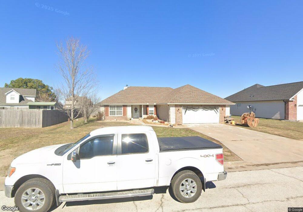
915 Larson St Carl Junction, MO 64834
Estimated Value: $229,000 - $262,000
3
Beds
2
Baths
1,700
Sq Ft
$146/Sq Ft
Est. Value
About This Home
This home is located at 915 Larson St, Carl Junction, MO 64834 and is currently estimated at $247,832, approximately $145 per square foot. 915 Larson St is a home located in Jasper County with nearby schools including Carl Junction Primary School (K-1), Carl Junction Intermediate School, and Carl Junction Primary School (2-3).
Ownership History
Date
Name
Owned For
Owner Type
Purchase Details
Closed on
Apr 23, 2021
Sold by
Miller Cheryl and Johnson James M
Bought by
Peters Keagan and Peters Lauren
Current Estimated Value
Home Financials for this Owner
Home Financials are based on the most recent Mortgage that was taken out on this home.
Original Mortgage
$168,884
Outstanding Balance
$152,399
Interest Rate
3.1%
Mortgage Type
FHA
Estimated Equity
$95,433
Purchase Details
Closed on
Feb 15, 2008
Sold by
Red Wood Development Inc
Bought by
Kelley Jason and Kelley Brittany
Home Financials for this Owner
Home Financials are based on the most recent Mortgage that was taken out on this home.
Original Mortgage
$137,000
Interest Rate
6.07%
Mortgage Type
Purchase Money Mortgage
Create a Home Valuation Report for This Property
The Home Valuation Report is an in-depth analysis detailing your home's value as well as a comparison with similar homes in the area
Home Values in the Area
Average Home Value in this Area
Purchase History
| Date | Buyer | Sale Price | Title Company |
|---|---|---|---|
| Peters Keagan | -- | None Available | |
| Kelley Jason | -- | Abbey |
Source: Public Records
Mortgage History
| Date | Status | Borrower | Loan Amount |
|---|---|---|---|
| Open | Peters Keagan | $168,884 | |
| Previous Owner | Kelley Jason | $137,000 |
Source: Public Records
Tax History Compared to Growth
Tax History
| Year | Tax Paid | Tax Assessment Tax Assessment Total Assessment is a certain percentage of the fair market value that is determined by local assessors to be the total taxable value of land and additions on the property. | Land | Improvement |
|---|---|---|---|---|
| 2025 | $1,532 | $29,680 | $2,130 | $27,550 |
| 2024 | $1,542 | $26,190 | $2,130 | $24,060 |
| 2023 | $1,542 | $26,190 | $2,130 | $24,060 |
| 2022 | $1,594 | $27,010 | $2,130 | $24,880 |
| 2021 | $1,368 | $27,010 | $2,130 | $24,880 |
| 2020 | $1,287 | $24,980 | $2,130 | $22,850 |
| 2019 | $1,222 | $24,980 | $2,130 | $22,850 |
| 2018 | $1,270 | $26,030 | $0 | $0 |
| 2017 | $1,274 | $26,030 | $0 | $0 |
| 2016 | $1,313 | $27,090 | $0 | $0 |
| 2015 | $1,286 | $27,090 | $0 | $0 |
| 2014 | $1,286 | $27,090 | $0 | $0 |
Source: Public Records
Map
Nearby Homes
- 907 Aberdeen Ave
- TBD Route Yy
- 29320 State Highway Yy
- Tract 3 Prairie Ln
- Tract 2 Prairie Ln
- Tract 1 Prairie Ln
- Tract 4 Prairie Ln
- 711 Prairie Ln
- 819 Delaney Dr
- 815 Delaney Dr
- Tract D1 County Road 284
- Tract D2 County Road 284
- Tract D3 County Road 284
- 409 Gault St
- 409 W Gault St
- 311 S Roney St
- 29865 State Highway Yy
- 505 W Walton Ave
- 1550KP-4 Plan at Rainer Farms
- 2360 Two Story Plan at Rainer Farms