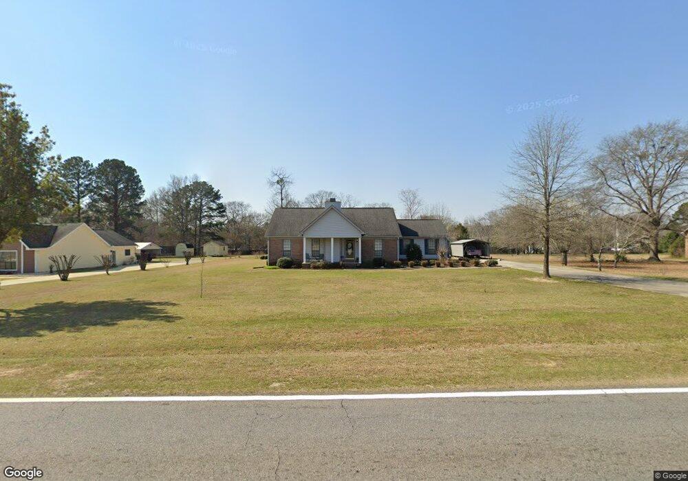
915 N Houston Lake Blvd Warner Robins, GA 31093
Estimated Value: $237,000 - $288,000
3
Beds
3
Baths
1,918
Sq Ft
$137/Sq Ft
Est. Value
About This Home
This home is located at 915 N Houston Lake Blvd, Warner Robins, GA 31093 and is currently estimated at $263,139, approximately $137 per square foot. 915 N Houston Lake Blvd is a home located in Houston County with nearby schools including Centerville Elementary School, Thomson Middle School, and Northside High School.
Ownership History
Date
Name
Owned For
Owner Type
Purchase Details
Closed on
Apr 20, 1991
Sold by
Snellgrove Larry G D and Snellgrove B
Bought by
Jackson Richard D
Current Estimated Value
Purchase Details
Closed on
Nov 30, 1990
Sold by
Snellgrove Larry
Bought by
Snellgrove Larry G D and Snellgrove B
Purchase Details
Closed on
Jun 30, 1989
Sold by
Parkway Square Inc
Bought by
Snellgrove Larry
Create a Home Valuation Report for This Property
The Home Valuation Report is an in-depth analysis detailing your home's value as well as a comparison with similar homes in the area
Home Values in the Area
Average Home Value in this Area
Purchase History
| Date | Buyer | Sale Price | Title Company |
|---|---|---|---|
| Jackson Richard D | -- | -- | |
| Snellgrove Larry G D | -- | -- | |
| Snellgrove Larry | -- | -- |
Source: Public Records
Tax History Compared to Growth
Tax History
| Year | Tax Paid | Tax Assessment Tax Assessment Total Assessment is a certain percentage of the fair market value that is determined by local assessors to be the total taxable value of land and additions on the property. | Land | Improvement |
|---|---|---|---|---|
| 2024 | $1,937 | $82,960 | $10,000 | $72,960 |
| 2023 | $1,648 | $70,200 | $10,000 | $60,200 |
| 2022 | $1,413 | $60,440 | $7,600 | $52,840 |
| 2021 | $1,338 | $57,080 | $7,600 | $49,480 |
| 2020 | $1,218 | $51,880 | $5,680 | $46,200 |
| 2019 | $1,218 | $51,880 | $5,680 | $46,200 |
| 2018 | $1,218 | $51,880 | $5,680 | $46,200 |
| 2017 | $1,219 | $51,880 | $5,680 | $46,200 |
| 2016 | $1,221 | $51,880 | $5,680 | $46,200 |
| 2015 | $1,223 | $51,880 | $5,680 | $46,200 |
| 2014 | -- | $51,880 | $5,680 | $46,200 |
| 2013 | -- | $49,120 | $6,000 | $43,120 |
Source: Public Records
Map
Nearby Homes
- 208 Sunnymeade Dr
- 205 Cambridge Dr
- 101 Kent Dr
- 118 Ridgewood Dr
- 111 Shamrock Dr
- 305 Brantley Rd Unit 6
- 116 Red Birch Ln
- 918 Collins Ave Unit 36
- 708 N Houston Lake Blvd
- 104 Sourwood Ln
- 184 Giles Rd
- 113 Sourwood Ln
- 113 Sourwood Ln
- 0 N Houston Lake Blvd
- 0 N Houston Lake Blvd Unit 10307131
- 110 Pilgrim Mill Trail
- 202 Brantley Rd
- 141 Back Cedar Ln
- 175 Arbor Creek
- 913 N Houston Lake Blvd
- 107 Kingstree Ln
- 109 Kingstree Ln
- 917 N Houston Lake Blvd
- 105 Kingstree Ln
- 111 Kingstree Ln
- 100 Wellington Way
- 102 Wellington Way
- 103 Kingstree Ln
- 0 Kingstree Ln Unit 8796442
- 0 Kingstree Ln Unit 8219383
- 0 Kingstree Ln Unit 8380989
- 140 English Oak Ln
- 104 Wellington Way
- 113 Kingstree Ln
- 101 Kingstree Ln
- 108 Kingstree Ln
- 106 Kingstree Ln
- 115 Kingstree Ln
- 110 Kingstree Ln