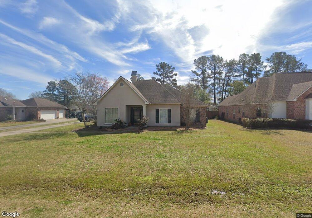
9155 Smoke Rock Dr Baton Rouge, LA 70817
Estimated Value: $364,024 - $392,000
--
Bed
--
Bath
2,295
Sq Ft
$164/Sq Ft
Est. Value
About This Home
This home is located at 9155 Smoke Rock Dr, Baton Rouge, LA 70817 and is currently estimated at $377,506, approximately $164 per square foot. 9155 Smoke Rock Dr is a home located in East Baton Rouge Parish with nearby schools including Woodlawn Elementary School, Woodlawn Middle School, and Woodlawn High School.
Ownership History
Date
Name
Owned For
Owner Type
Purchase Details
Closed on
Jul 22, 2016
Sold by
Zeringue Jesse J and Zeringue Gina Bilello
Bought by
Haven Christopher K and Nohra Anna Marie
Current Estimated Value
Home Financials for this Owner
Home Financials are based on the most recent Mortgage that was taken out on this home.
Original Mortgage
$276,450
Outstanding Balance
$220,833
Interest Rate
3.6%
Mortgage Type
New Conventional
Estimated Equity
$156,673
Create a Home Valuation Report for This Property
The Home Valuation Report is an in-depth analysis detailing your home's value as well as a comparison with similar homes in the area
Home Values in the Area
Average Home Value in this Area
Purchase History
| Date | Buyer | Sale Price | Title Company |
|---|---|---|---|
| Haven Christopher K | $285,000 | Attorney |
Source: Public Records
Mortgage History
| Date | Status | Borrower | Loan Amount |
|---|---|---|---|
| Open | Haven Christopher K | $276,450 |
Source: Public Records
Tax History Compared to Growth
Tax History
| Year | Tax Paid | Tax Assessment Tax Assessment Total Assessment is a certain percentage of the fair market value that is determined by local assessors to be the total taxable value of land and additions on the property. | Land | Improvement |
|---|---|---|---|---|
| 2024 | $3,150 | $34,840 | $3,000 | $31,840 |
| 2023 | $3,165 | $29,840 | $3,000 | $26,840 |
| 2022 | $3,380 | $29,840 | $3,000 | $26,840 |
| 2021 | $3,314 | $29,840 | $3,000 | $26,840 |
| 2020 | $3,357 | $29,840 | $3,000 | $26,840 |
| 2019 | $3,339 | $28,500 | $3,000 | $25,500 |
| 2018 | $3,296 | $28,500 | $3,000 | $25,500 |
| 2017 | $3,296 | $28,500 | $3,000 | $25,500 |
| 2016 | $2,141 | $26,400 | $3,000 | $23,400 |
| 2015 | $1,755 | $22,950 | $3,000 | $19,950 |
| 2014 | $1,718 | $22,950 | $3,000 | $19,950 |
| 2013 | -- | $22,950 | $3,000 | $19,950 |
Source: Public Records
Map
Nearby Homes
- 16632 Highland Club Ave
- 9504 Country Lake Dr
- 17483 Waterloo Dr
- 17525 Waterloo Dr
- 17725 Nine Oaks Ave
- 17723 Twin Ridge Ave
- 17755 Ridge Park Ave
- 7223 Antioch Rd
- 8637 Greenbrier Cove Rd
- 8631 Greenbrier Cove Rd
- 17656 Chasefield Ave
- 8625 Greenbrier Cove Rd
- 8619 Greenbrier Cove Rd
- 8613 Greenbrier Cove Rd
- 8607 Greenbrier Cove Rd
- 8643 Greenbrier Cove Rd
- 8343 Hattic St
- 8644 Greenbrier Cove Rd
- 8638 Greenbrier Cove Rd
- 8626 Greenbrier Cove Rd
- 9203 Smoke Rock Dr
- 9213 Smoke Rock Dr
- 9135 Smoke Rock Dr
- 9226 Kindletree Dr
- 9216 Kindletree Dr
- 9318 Kindletree Dr
- 16444 Round Rock Ct
- 9144 Kindletree Dr
- 16433 Round Rock Ct
- 9125 Smoke Rock Dr
- 9328 Kindletree Dr
- 16434 Round Rock Ct
- 9124 Kindletree Dr
- 9214 Smoke Rock Dr
- 16423 Round Rock Ct
- 9115 Smoke Rock Dr
- 16424 Round Rock Ct
- 9032 Kindletree Dr
- 9234 Smoke Rock Dr
- 9224 Smoke Rock Dr