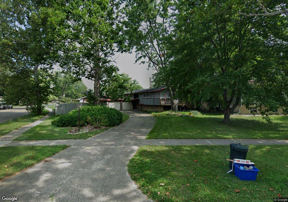
916 Devonshire Dr Champaign, IL 61821
Bolten Field NeighborhoodEstimated Value: $267,000 - $348,000
Studio
2
Baths
1,471
Sq Ft
$209/Sq Ft
Est. Value
About This Home
This home is located at 916 Devonshire Dr, Champaign, IL 61821 and is currently estimated at $308,130, approximately $209 per square foot. 916 Devonshire Dr is a home located in Champaign County with nearby schools including Central High School, Devonshire KinderCare, and Montessori Habitat School.
Ownership History
Date
Name
Owned For
Owner Type
Purchase Details
Closed on
Feb 13, 2018
Sold by
Albert John P
Bought by
Albert Stuart L and Nectoux Tracy M
Current Estimated Value
Purchase Details
Closed on
Nov 21, 2012
Sold by
Nguyen Jack and Nguyen Sue Ann
Bought by
Albert Stuart L and Albert John P
Home Financials for this Owner
Home Financials are based on the most recent Mortgage that was taken out on this home.
Original Mortgage
$142,400
Outstanding Balance
$98,168
Interest Rate
3.34%
Mortgage Type
New Conventional
Estimated Equity
$209,962
Create a Home Valuation Report for This Property
The Home Valuation Report is an in-depth analysis detailing your home's value as well as a comparison with similar homes in the area
Home Values in the Area
Average Home Value in this Area
Purchase History
| Date | Buyer | Sale Price | Title Company |
|---|---|---|---|
| Albert Stuart L | -- | Attorney | |
| Albert Stuart L | -- | Attorney | |
| Albert Stuart L | $178,000 | None Available |
Source: Public Records
Mortgage History
| Date | Status | Borrower | Loan Amount |
|---|---|---|---|
| Open | Albert Stuart L | $142,400 |
Source: Public Records
Tax History
| Year | Tax Paid | Tax Assessment Tax Assessment Total Assessment is a certain percentage of the fair market value that is determined by local assessors to be the total taxable value of land and additions on the property. | Land | Improvement |
|---|---|---|---|---|
| 2024 | $6,399 | $84,500 | $27,720 | $56,780 |
| 2023 | $6,399 | $76,960 | $25,250 | $51,710 |
| 2022 | $5,976 | $70,990 | $23,290 | $47,700 |
| 2021 | $5,821 | $69,590 | $22,830 | $46,760 |
| 2020 | $5,585 | $66,910 | $21,950 | $44,960 |
| 2019 | $5,395 | $65,540 | $21,500 | $44,040 |
| 2018 | $5,265 | $64,510 | $21,160 | $43,350 |
| 2017 | $5,063 | $62,030 | $20,350 | $41,680 |
| 2016 | $4,529 | $60,750 | $19,930 | $40,820 |
| 2015 | $4,555 | $59,680 | $19,580 | $40,100 |
| 2014 | $4,516 | $59,680 | $19,580 | $40,100 |
| 2013 | $4,475 | $59,680 | $19,580 | $40,100 |
Source: Public Records
Map
Nearby Homes
- 809 Ayrshire Dr
- 716 Devonshire Dr
- 20 Ashley Ln
- 1205 Broadmoor Dr
- 901 Kent Dr
- 1310 Broadmoor Dr
- 1315 Broadmoor Dr
- 1506 Sandpiper Ln
- 2211 Carlisle Dr
- 812 Dodds Dr
- 2410 Stillwater Dr
- 2501 Bedford Dr
- 21 Greencroft Dr
- 22 Greencroft Dr
- 2404 Windward Blvd Unit 201
- 2404 Windward Blvd Unit 202
- 2317 Brookshire E
- 1722 Lakeside Dr
- 2134 Harbortown Cir
- 2144 Harbortown Cir Unit 2144
- 914 Devonshire Dr
- 2004 Lynwood Dr
- 1919 David Dr
- 912 Devonshire Dr
- 1002 Devonshire Dr
- 1921 David Dr
- 2002 Lynwood Dr
- 1917 David Dr
- 2102 Lynwood Dr
- 910 Devonshire Dr
- 910 Devonshire Dr Unit 103
- 1001 Devonshire Dr
- 2003 Lynwood Dr
- 1004 Devonshire Dr
- 1922 David Dr
- 911 Devonshire Dr
- 1916 Lynwood Dr
- 1915 David Dr
- 2001 Lynwood Dr
- 1005 Devonshire Dr
Your Personal Tour Guide
Ask me questions while you tour the home.