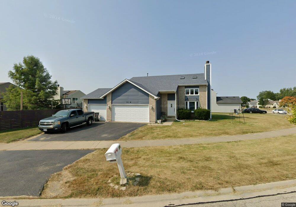
916 Pheasant Run Zion, IL 60099
West Zion NeighborhoodEstimated Value: $320,000 - $344,905
3
Beds
4
Baths
1,929
Sq Ft
$174/Sq Ft
Est. Value
About This Home
This home is located at 916 Pheasant Run, Zion, IL 60099 and is currently estimated at $335,976, approximately $174 per square foot. 916 Pheasant Run is a home located in Lake County with nearby schools including Newport Elementary School, Beach Park Middle School, and Zion-Benton Township High School.
Ownership History
Date
Name
Owned For
Owner Type
Purchase Details
Closed on
Jul 2, 2001
Sold by
Bank Of Waukegan
Bought by
Alter Kenneth L and Alter Judith L
Current Estimated Value
Home Financials for this Owner
Home Financials are based on the most recent Mortgage that was taken out on this home.
Original Mortgage
$180,000
Outstanding Balance
$69,771
Interest Rate
7.22%
Estimated Equity
$266,205
Create a Home Valuation Report for This Property
The Home Valuation Report is an in-depth analysis detailing your home's value as well as a comparison with similar homes in the area
Home Values in the Area
Average Home Value in this Area
Purchase History
| Date | Buyer | Sale Price | Title Company |
|---|---|---|---|
| Alter Kenneth L | $199,500 | Chicago Title Insurance Co |
Source: Public Records
Mortgage History
| Date | Status | Borrower | Loan Amount |
|---|---|---|---|
| Open | Alter Kenneth L | $180,000 |
Source: Public Records
Tax History Compared to Growth
Tax History
| Year | Tax Paid | Tax Assessment Tax Assessment Total Assessment is a certain percentage of the fair market value that is determined by local assessors to be the total taxable value of land and additions on the property. | Land | Improvement |
|---|---|---|---|---|
| 2024 | $7,727 | $85,778 | $9,916 | $75,862 |
| 2023 | $8,678 | $76,478 | $8,841 | $67,637 |
| 2022 | $8,678 | $77,507 | $7,267 | $70,240 |
| 2021 | $8,508 | $72,708 | $6,817 | $65,891 |
| 2020 | $8,160 | $68,386 | $6,412 | $61,974 |
| 2019 | $7,892 | $63,704 | $5,973 | $57,731 |
| 2018 | $7,082 | $57,640 | $5,420 | $52,220 |
| 2017 | $6,911 | $53,470 | $5,028 | $48,442 |
| 2016 | $6,317 | $48,538 | $4,564 | $43,974 |
| 2015 | $5,964 | $44,041 | $4,141 | $39,900 |
| 2014 | $5,951 | $44,508 | $4,295 | $40,213 |
| 2012 | $6,598 | $47,399 | $4,574 | $42,825 |
Source: Public Records
Map
Nearby Homes
- 1210 Lorelei Dr
- 4108 Douglas Dr
- 4004 Gregory Dr
- 1305 Reed Rd
- 3903 9th St
- 4013 Ridge Rd
- 4014 Ridge Rd
- 1524 Anderson Trail
- 11778 W 12th St
- 1712 Dusk Dr
- 4539 Illinois 173
- 4533 Illinois 173
- 1907 Dawn Ln
- 42908 N Lewis Ave
- 1521 Southport Ct
- 1405 Lewis Ave
- 210 Oak Ln
- 42771 N Delany Rd
- 43100 N Lewis Ave
- 42333 N Theodore Ct
- 914 Pheasant Run
- 4202 Swan Ln
- 4200 Swan Ln
- 4204 Swan Ln
- 912 Pheasant Run
- 919 Pheasant Run
- 921 Pheasant Run
- 917 Pheasant Run
- 1001 Pheasant Run
- 4206 Swan Ln
- 1003 Pheasant Run
- 913 Countrywood Dr
- 915 Pheasant Run
- 910 Pheasant Run
- 1005 Pheasant Run
- 4208 Swan Ln
- 911 Countrywood Dr
- 4203 Swan Ln
- 1007 Pheasant Run