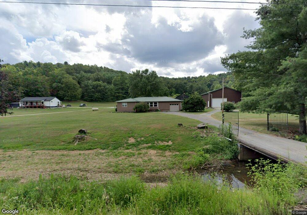
9164 State Route 243 South Point, OH 45680
--
Bed
2
Baths
--
Sq Ft
47.67
Acres
About This Home
This home is located at 9164 State Route 243, South Point, OH 45680. 9164 State Route 243 is a home located in Lawrence County with nearby schools including Dawson-Bryant Elementary School, Dawson-Bryant Middle School, and Dawson-Bryant High School.
Ownership History
Date
Name
Owned For
Owner Type
Purchase Details
Closed on
May 12, 2015
Sold by
Barmmer Danny K and Barmmer Sherry L
Bought by
Galloway James W and Galloway Laura B
Purchase Details
Closed on
May 12, 2014
Sold by
Brammer Danny K and Brammer Sherry L
Bought by
Brammer Danny K and Brammer Sherry L
Purchase Details
Closed on
Aug 30, 2011
Sold by
Brammer Danny K and Brammer Sherry L
Bought by
Brammer Danny K and Brammer Sherry L
Purchase Details
Closed on
Oct 21, 2005
Sold by
Johnson David A and Johnson L
Bought by
Brammer Danny K and Brammer Sherry L
Purchase Details
Closed on
Jul 29, 1999
Sold by
Baisden Seigle and Baisden Vivian
Bought by
Johnson David A and Johnson L
Purchase Details
Closed on
Apr 15, 1999
Sold by
Baisden Seigle and Baisden Vivian
Bought by
Baisden Seigle and Baisden Vivian
Create a Home Valuation Report for This Property
The Home Valuation Report is an in-depth analysis detailing your home's value as well as a comparison with similar homes in the area
Home Values in the Area
Average Home Value in this Area
Purchase History
| Date | Buyer | Sale Price | Title Company |
|---|---|---|---|
| Galloway James W | $50,000 | Attorney | |
| Brammer Danny K | -- | None Available | |
| Brammer Danny K | -- | None Available | |
| Brammer Danny K | $282,500 | Bestitle Agency Inc | |
| Johnson David A | $220,000 | -- | |
| Baisden Seigle | -- | -- |
Source: Public Records
Tax History Compared to Growth
Tax History
| Year | Tax Paid | Tax Assessment Tax Assessment Total Assessment is a certain percentage of the fair market value that is determined by local assessors to be the total taxable value of land and additions on the property. | Land | Improvement |
|---|---|---|---|---|
| 2024 | -- | $17,920 | $17,920 | -- |
| 2023 | $147 | $17,920 | $17,920 | $0 |
| 2022 | $147 | $17,920 | $17,920 | $0 |
| 2021 | $136 | $12,140 | $12,140 | $0 |
| 2020 | $136 | $12,140 | $12,140 | $0 |
| 2019 | $135 | $12,140 | $12,140 | $0 |
| 2018 | $201 | $11,900 | $11,900 | $0 |
| 2017 | $10 | $11,900 | $11,900 | $0 |
| 2016 | $187 | $11,900 | $11,900 | $0 |
| 2015 | $211 | $11,900 | $11,900 | $0 |
| 2014 | -- | $11,900 | $11,900 | $0 |
| 2013 | $277 | $16,880 | $15,480 | $1,400 |
Source: Public Records
Map
Nearby Homes
- 9040 Ohio 243
- 66 County Road 30
- 6881 State Route 243
- 3493 County Road 31
- 1122 Township Road 266
- 1122 Township Road 266
- 3171 County Road 31
- 66 Township Road 1523
- 25 Township Road 1524
- 3569 County Road 6
- 4404 County Road 15
- 71 Private Dr
- 6757 County Road 15
- 6897 County Road 15
- 859 County Road 53
- 885 County Road 53
- 00 Township Road 219 N
- 1334 McKinney Creek-Hesson Hollow Rd N
- 1334 Township Road 214th N
- 7428 County Road 15
- 9097 State Route 243
- 9088 State Route 243
- 9247 State Route 243
- 9287 State Route 243
- 9301 State Route 243
- 9317 State Route 243
- 8829 State Route 243
- 8969 State Route 243
- 203 Private Road 1653 Unit 17
- 8881 State Route 243
- 4113 County Road 55
- 4036 County Road 55
- 9466 State Route 243
- 4091 County Road 55
- 4014 County Road 55
- 9504 Ohio 243
- 9504 State Route 243
- 8902 State Route 243
- 22 Private Road 1653 Unit 17
- 3954 County Road 55