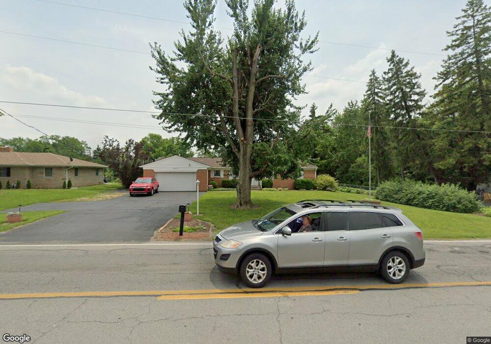
917 Fry Rd Greenwood, IN 46142
Estimated Value: $268,000 - $305,567
3
Beds
2
Baths
1,644
Sq Ft
$175/Sq Ft
Est. Value
About This Home
This home is located at 917 Fry Rd, Greenwood, IN 46142 and is currently estimated at $288,392, approximately $175 per square foot. 917 Fry Rd is a home located in Johnson County with nearby schools including Southwest Elementary School, Greenwood Middle School, and Greenwood Community High School.
Ownership History
Date
Name
Owned For
Owner Type
Purchase Details
Closed on
Jun 17, 2005
Sold by
Metro Holding Company L P
Bought by
Henson Larry Dean and Henson Victoria Lee
Current Estimated Value
Home Financials for this Owner
Home Financials are based on the most recent Mortgage that was taken out on this home.
Original Mortgage
$112,000
Outstanding Balance
$74,682
Interest Rate
10.45%
Mortgage Type
Adjustable Rate Mortgage/ARM
Estimated Equity
$213,710
Create a Home Valuation Report for This Property
The Home Valuation Report is an in-depth analysis detailing your home's value as well as a comparison with similar homes in the area
Home Values in the Area
Average Home Value in this Area
Purchase History
| Date | Buyer | Sale Price | Title Company |
|---|---|---|---|
| Henson Larry Dean | -- | None Available |
Source: Public Records
Mortgage History
| Date | Status | Borrower | Loan Amount |
|---|---|---|---|
| Open | Henson Larry Dean | $112,000 |
Source: Public Records
Tax History Compared to Growth
Tax History
| Year | Tax Paid | Tax Assessment Tax Assessment Total Assessment is a certain percentage of the fair market value that is determined by local assessors to be the total taxable value of land and additions on the property. | Land | Improvement |
|---|---|---|---|---|
| 2025 | $2,034 | $270,700 | $64,700 | $206,000 |
| 2024 | $2,034 | $263,000 | $64,700 | $198,300 |
| 2023 | $1,823 | $252,800 | $64,700 | $188,100 |
| 2022 | $1,816 | $233,400 | $57,700 | $175,700 |
| 2021 | $1,144 | $178,500 | $37,400 | $141,100 |
| 2020 | $1,068 | $169,500 | $37,400 | $132,100 |
| 2019 | $949 | $159,400 | $37,400 | $122,000 |
| 2018 | $892 | $154,400 | $27,800 | $126,600 |
| 2017 | $886 | $153,300 | $27,800 | $125,500 |
| 2016 | $779 | $142,400 | $27,800 | $114,600 |
| 2014 | $686 | $135,600 | $29,100 | $106,500 |
| 2013 | $686 | $127,100 | $27,300 | $99,800 |
Source: Public Records
Map
Nearby Homes
- 935 Fry Rd
- 1065 Lawndale Ct
- 1081 Lawndale Dr
- 855 Gazebo Way Unit C
- 1064 Laurelwood Ln
- 601 Lawnwood Dr
- 1039 Galaxie Dr
- 975 Rolling Hill Rd
- 783 Colonial Way
- 610 Wood Dale Terrace
- 988 Rolling Hill Rd
- 344 Lawnwood Dr
- 805 Riverside Dr
- 167 Howard Rd
- 583 Shady Creek Dr
- 1110 Barefoot Trail
- 399 Us Highway 31 N
- 320 Elmead Ct Unit 2002
- 520 Valley Lane Dr N
- 314 Elmead Ct Unit 2007