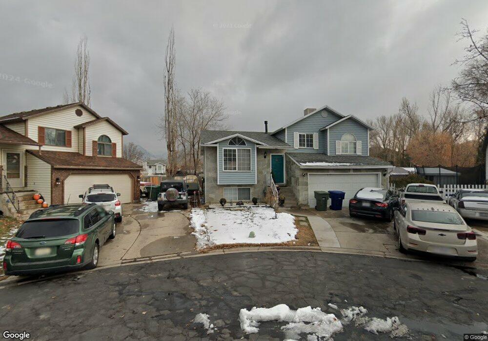
918 Brookside Cir Ogden, UT 84404
Lynn NeighborhoodEstimated Value: $395,991 - $420,000
5
Beds
1
Bath
1,436
Sq Ft
$285/Sq Ft
Est. Value
About This Home
This home is located at 918 Brookside Cir, Ogden, UT 84404 and is currently estimated at $408,998, approximately $284 per square foot. 918 Brookside Cir is a home located in Weber County with nearby schools including Heritage Elementary School, Highland Junior High School, and Ben Lomond High School.
Ownership History
Date
Name
Owned For
Owner Type
Purchase Details
Closed on
Nov 7, 2024
Sold by
Saucedo Delia and Tovar Delia
Bought by
Saucedo Delia A
Current Estimated Value
Purchase Details
Closed on
Nov 18, 2022
Sold by
Tovar Jose T
Bought by
Saucedo Delia A
Home Financials for this Owner
Home Financials are based on the most recent Mortgage that was taken out on this home.
Original Mortgage
$100,000
Interest Rate
7.08%
Mortgage Type
New Conventional
Purchase Details
Closed on
Jun 8, 2018
Sold by
Tovar Jose T
Bought by
Sauccdo Delia A
Purchase Details
Closed on
Jul 27, 1998
Sold by
Jones David K and Hawks Kay L
Bought by
Tovar Jose
Home Financials for this Owner
Home Financials are based on the most recent Mortgage that was taken out on this home.
Original Mortgage
$112,270
Interest Rate
7.01%
Mortgage Type
FHA
Create a Home Valuation Report for This Property
The Home Valuation Report is an in-depth analysis detailing your home's value as well as a comparison with similar homes in the area
Home Values in the Area
Average Home Value in this Area
Purchase History
| Date | Buyer | Sale Price | Title Company |
|---|---|---|---|
| Saucedo Delia A | -- | Lincoln Title | |
| Saucedo Delia A | -- | Lincoln Title | |
| Saucedo Delia A | -- | -- | |
| Sauccdo Delia A | -- | None Available | |
| Tovar Jose | -- | First American Title |
Source: Public Records
Mortgage History
| Date | Status | Borrower | Loan Amount |
|---|---|---|---|
| Previous Owner | Saucedo Delia A | $100,000 | |
| Previous Owner | Tovar Jose | $112,270 |
Source: Public Records
Tax History
| Year | Tax Paid | Tax Assessment Tax Assessment Total Assessment is a certain percentage of the fair market value that is determined by local assessors to be the total taxable value of land and additions on the property. | Land | Improvement |
|---|---|---|---|---|
| 2025 | $2,683 | $216,315 | $65,079 | $151,236 |
| 2024 | $2,667 | $211,199 | $65,078 | $146,121 |
| 2023 | $2,561 | $204,050 | $60,616 | $143,434 |
| 2022 | $2,520 | $201,300 | $44,430 | $156,870 |
| 2021 | $2,081 | $276,000 | $56,117 | $219,883 |
| 2020 | $2,008 | $246,000 | $41,723 | $204,277 |
| 2019 | $1,896 | $218,000 | $32,098 | $185,902 |
| 2018 | $1,636 | $187,000 | $32,009 | $154,991 |
| 2017 | $1,508 | $161,000 | $32,281 | $128,719 |
| 2016 | $1,297 | $74,816 | $17,755 | $57,061 |
| 2015 | $1,267 | $71,314 | $17,755 | $53,559 |
| 2014 | $1,290 | $71,313 | $14,880 | $56,433 |
Source: Public Records
Map
Nearby Homes
- 889 S Clover Cir
- 820 S Wildflower Cir
- 445 950 S
- 447 950 S
- 900 Century Dr Unit 130
- 900 Century Dr Unit 69
- 900 Century Dr Unit 60
- 900 Century Dr Unit 66
- 447 W 980 S
- 451 W 980 S
- 1446 S 410 W Unit 135
- 617 S 375 W
- 155 E 900 St S Unit 108
- 155 E 900 St S Unit 202
- 1288 Lincoln Ave
- 130 7th #C304 St
- 142 7th St Unit B304
- 1325 Lincoln Ave Unit 19
- 1325 Lincoln Ave Unit 52
- 1325 Lincoln Ave Unit 110
- 923 Brookside Cir Unit 50
- 914 Brookside Cir Unit 48
- 949 S 300 W
- 955 S 300 W
- 921 Brookside Cir
- 921 Brookside Cir Unit 51
- 908 Brookside Cir
- 917 Brookside Cir
- 311 Meadowbrook Dr
- 317 Meadowbrook Dr
- 950 950 S
- 323 W 900 South St
- 969 S 300 W
- 323 W 900 S
- 323 W Meadowbrook Dr
- 911 Brookside Cir Unit 53
- 323 9th St
- 898 Brookside Cir
- 944 S 300 W
- 898 S Brookside Cir
Your Personal Tour Guide
Ask me questions while you tour the home.