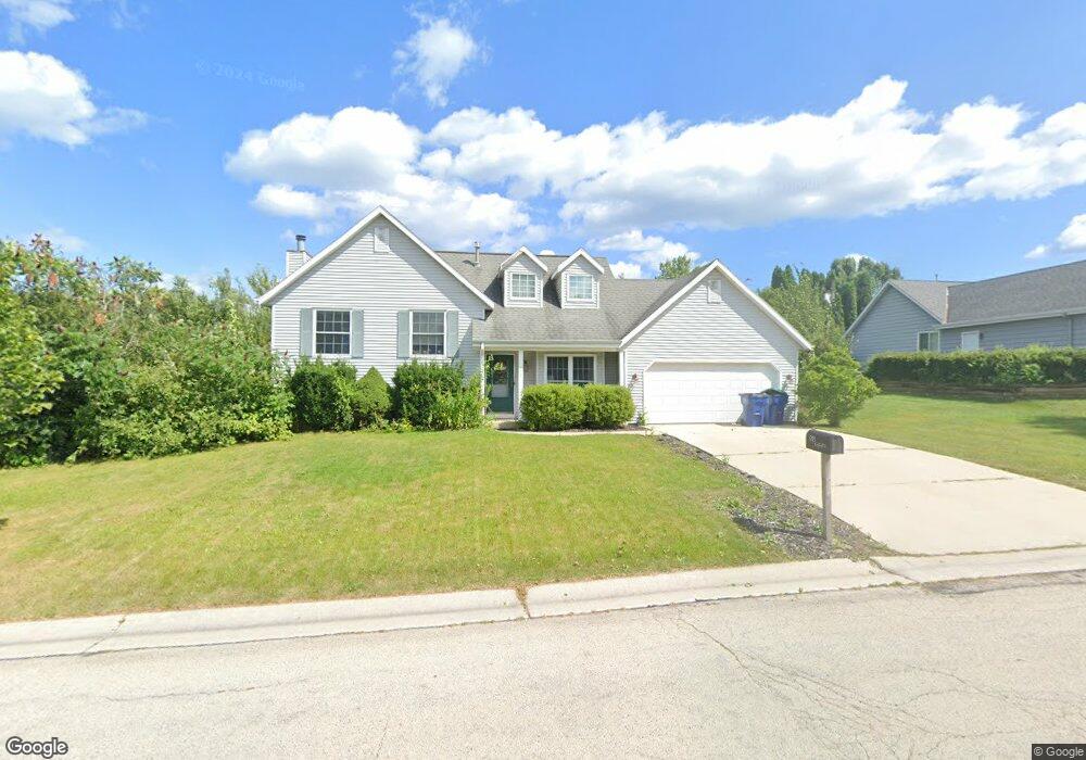
918 Westport Dr Port Washington, WI 53074
Estimated Value: $391,000 - $416,000
3
Beds
2
Baths
1,696
Sq Ft
$236/Sq Ft
Est. Value
About This Home
This home is located at 918 Westport Dr, Port Washington, WI 53074 and is currently estimated at $400,622, approximately $236 per square foot. 918 Westport Dr is a home located in Ozaukee County with nearby schools including Dunwiddie Elementary School, Thomas Jefferson Middle School, and Port Washington High School.
Ownership History
Date
Name
Owned For
Owner Type
Purchase Details
Closed on
Apr 12, 2021
Sold by
Mattick Andrew
Bought by
Mattick Andrew and Mattick Amanda
Current Estimated Value
Purchase Details
Closed on
Mar 20, 2020
Sold by
Grossmeyer Steven J and Grossmeyer Debra L
Bought by
Mattick Andrew
Home Financials for this Owner
Home Financials are based on the most recent Mortgage that was taken out on this home.
Original Mortgage
$249,850
Outstanding Balance
$220,856
Interest Rate
3.4%
Mortgage Type
New Conventional
Estimated Equity
$179,766
Create a Home Valuation Report for This Property
The Home Valuation Report is an in-depth analysis detailing your home's value as well as a comparison with similar homes in the area
Home Values in the Area
Average Home Value in this Area
Purchase History
| Date | Buyer | Sale Price | Title Company |
|---|---|---|---|
| Mattick Andrew | -- | None Available | |
| Mattick Andrew | $263,000 | Knight Barry Title |
Source: Public Records
Mortgage History
| Date | Status | Borrower | Loan Amount |
|---|---|---|---|
| Open | Mattick Andrew | $249,850 |
Source: Public Records
Tax History Compared to Growth
Tax History
| Year | Tax Paid | Tax Assessment Tax Assessment Total Assessment is a certain percentage of the fair market value that is determined by local assessors to be the total taxable value of land and additions on the property. | Land | Improvement |
|---|---|---|---|---|
| 2024 | $4,026 | $256,200 | $78,000 | $178,200 |
| 2023 | $3,587 | $256,200 | $78,000 | $178,200 |
| 2022 | $3,636 | $256,200 | $78,000 | $178,200 |
| 2021 | $3,572 | $256,200 | $78,000 | $178,200 |
| 2020 | $3,677 | $201,800 | $65,900 | $135,900 |
| 2019 | $3,750 | $201,800 | $65,900 | $135,900 |
| 2018 | $3,643 | $201,800 | $65,900 | $135,900 |
| 2017 | $3,595 | $201,800 | $65,900 | $135,900 |
| 2016 | $3,608 | $201,800 | $65,900 | $135,900 |
| 2015 | $3,517 | $201,800 | $65,900 | $135,900 |
| 2014 | $3,307 | $201,800 | $65,900 | $135,900 |
| 2013 | $3,522 | $201,800 | $65,900 | $135,900 |
Source: Public Records
Map
Nearby Homes
- 924 Westport Dr
- 723 Willow Ct
- 1000 S Spring St
- 675 Amber Ln
- 125 S Summit Dr
- 732 Maritime Dr
- 715 Maritime Dr
- 716 Maritime Dr
- 717 Maritime Dr
- 730 Maritime Dr
- 733 Maritime Dr
- 736 Maritime Dr
- 905 W Larabee St
- Lt2 Woodridge Ln
- 1579 Woodridge Ln
- 1799 Sweetwater Blvd
- 360 Sweetwater Blvd
- 348 Sweetwater Blvd
- 336 Sweetwater Blvd
- 500 Sweetwater Blvd Unit 202
- 1418 Maple Ct
- 912 Westport Dr
- 1412 Maple Ct
- 929 Westport Dr
- 935 Westport Dr
- 906 Westport Dr
- 923 Westport Dr
- 1406 Maple Ct
- 917 Westport Dr
- 1006 Westport Dr
- 1436 Hickory Ct
- 1415 Maple Ct
- 1367 Sumac Ct
- 1409 Maple Ct
- 900 Westport Dr
- 911 Westport Dr
- 1403 Maple Ct
- 1366 Maple Ct
- 1005 Westport Dr
- 1447 Cedar Dr