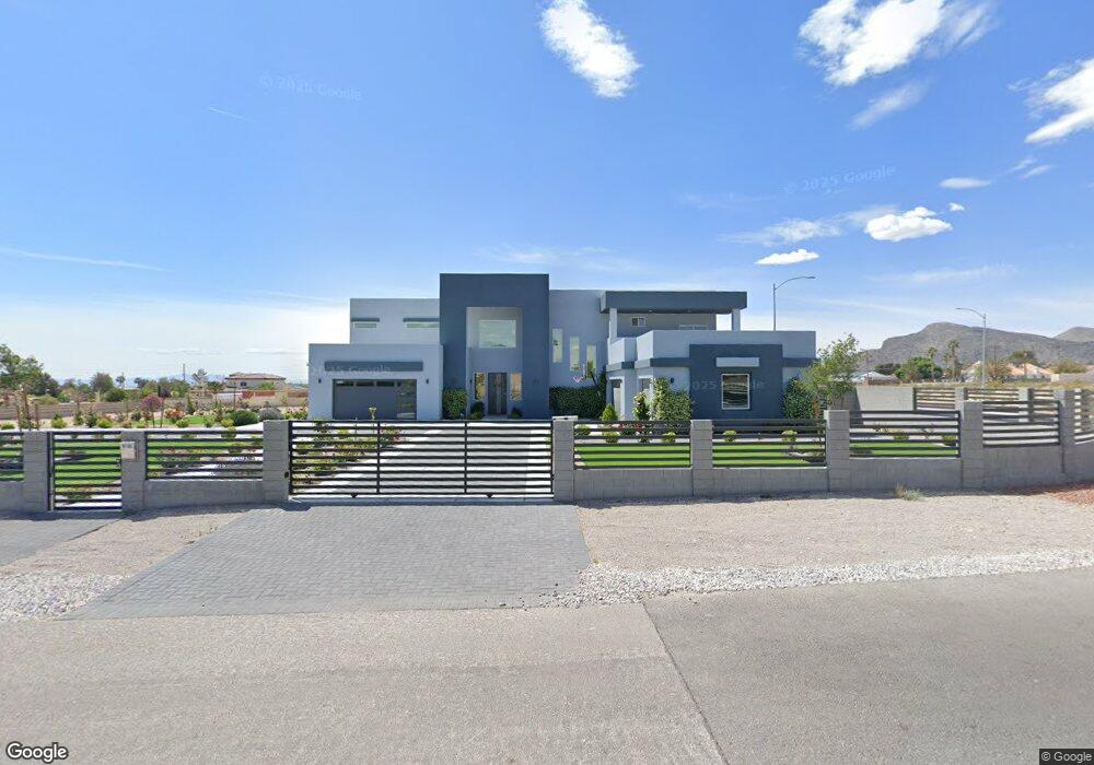
9185 W Fisher Ave Las Vegas, NV 89149
Estimated Value: $1,255,000 - $2,567,120
4
Beds
5
Baths
4,972
Sq Ft
$353/Sq Ft
Est. Value
About This Home
This home is located at 9185 W Fisher Ave, Las Vegas, NV 89149 and is currently estimated at $1,757,280, approximately $353 per square foot. 9185 W Fisher Ave is a home with nearby schools including Dean Lamar Allen Elementary School, Justice Myron E Leavitt Middle School, and Centennial High School.
Ownership History
Date
Name
Owned For
Owner Type
Purchase Details
Closed on
Jun 26, 2024
Sold by
Monarrez Manuel A and Monarrez Clara A
Bought by
Mongaxi Family Trust and Monarrez
Current Estimated Value
Purchase Details
Closed on
Mar 26, 2022
Sold by
Monarrez Manuel A and Monarrez Clara A
Bought by
Monarrez Manuel A and Monarrez Clara A
Home Financials for this Owner
Home Financials are based on the most recent Mortgage that was taken out on this home.
Original Mortgage
$742,500
Interest Rate
3.92%
Mortgage Type
New Conventional
Create a Home Valuation Report for This Property
The Home Valuation Report is an in-depth analysis detailing your home's value as well as a comparison with similar homes in the area
Home Values in the Area
Average Home Value in this Area
Purchase History
| Date | Buyer | Sale Price | Title Company |
|---|---|---|---|
| Mongaxi Family Trust | -- | None Listed On Document | |
| Mongaxi Family Trust | -- | None Listed On Document | |
| Monarrez Manuel A | $200,000 | None Listed On Document |
Source: Public Records
Mortgage History
| Date | Status | Borrower | Loan Amount |
|---|---|---|---|
| Previous Owner | Monarrez Manuel A | $742,500 |
Source: Public Records
Tax History Compared to Growth
Tax History
| Year | Tax Paid | Tax Assessment Tax Assessment Total Assessment is a certain percentage of the fair market value that is determined by local assessors to be the total taxable value of land and additions on the property. | Land | Improvement |
|---|---|---|---|---|
| 2025 | $15,324 | $630,926 | $100,625 | $530,301 |
| 2024 | $13,120 | $630,926 | $100,625 | $530,301 |
| 2023 | $13,120 | $532,081 | $98,438 | $433,643 |
| 2022 | $12,833 | $87,500 | $87,500 | $0 |
| 2021 | $1,912 | $0 | $0 | $0 |
| 2020 | -- | $118,213 | $118,213 | $0 |
| 2019 | -- | $118,213 | $118,213 | $0 |
| 2018 | -- | $94,570 | $94,570 | $0 |
| 2017 | -- | $84,438 | $84,438 | $0 |
| 2016 | -- | $67,550 | $67,550 | $0 |
| 2015 | -- | $54,040 | $54,040 | $0 |
| 2014 | -- | $33,775 | $33,775 | $0 |
Source: Public Records
Map
Nearby Homes
- 0 Dapple Gray Rd
- 5315 N Fort Apache Rd
- 5309 N Chieftain St
- 9180 W Hammer Ln
- 9340 W Washburn Rd
- 3336 Plan at Homestead West
- 3704 Plan at Homestead West
- 11127 Rolling Vista Dr
- 5515 N Campbell Rd
- Primrose Plan at Crestwood Ranch
- Mesquite Plan at Crestwood Ranch
- 9428 New Discovery Ave
- Kathryn NextGen w/RV Plan at The Estates - Ann
- Leighton NextGen w/RV Plan at The Estates - El Capitan
- Ganon NextGen w/RV Plan at The Estates - Ann
- Ganon NextGen w/RV Plan at The Estates - El Capitan
- Leighton NextGen w/RV Plan at The Estates - Ann
- Kathryn NextGen w/RV Plan at The Estates - El Capitan
- 5624 N Dapple Gray Rd
- 5120 Lone View Place
- 9180 W Washburn Rd
- 0 W Fisher Ave
- 9190 W Fisher Ave
- 9160 W Fisher Ave
- 9190 W Washburn Rd
- 5285 N Dapple Gray Rd
- 5325 N Dapple Gray Rd
- 5245 N Dapple Gray Rd
- 9180 W Fisher Ave
- 9140 W Washburn Rd
- 9170 W Fisher Ave
- 5335 N Fort Apache Rd
- 5315 N Dapple Gray Rd
- 5345 N Fort Apache Rd
- 5522 Dapple Gray Rd
- 5345 N Dapple Gray Rd
- 5195 N Fort Apache Rd
- 5365 N Fort Apache Rd
- 9250 W Washburn Rd