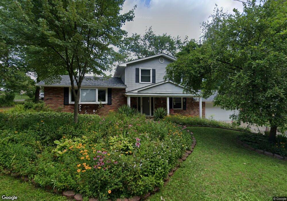
919 7th St NW North Canton, OH 44720
Estimated Value: $213,000 - $273,000
3
Beds
2
Baths
1,296
Sq Ft
$190/Sq Ft
Est. Value
About This Home
This home is located at 919 7th St NW, North Canton, OH 44720 and is currently estimated at $246,183, approximately $189 per square foot. 919 7th St NW is a home located in Stark County with nearby schools including Orchard Hill Intermediate School, North Canton Middle School, and Hoover High School.
Ownership History
Date
Name
Owned For
Owner Type
Purchase Details
Closed on
Aug 25, 2003
Sold by
Kenny Harold M and Kenny Margaret A
Bought by
Summers Marie A
Current Estimated Value
Home Financials for this Owner
Home Financials are based on the most recent Mortgage that was taken out on this home.
Original Mortgage
$112,100
Interest Rate
5.62%
Mortgage Type
Purchase Money Mortgage
Create a Home Valuation Report for This Property
The Home Valuation Report is an in-depth analysis detailing your home's value as well as a comparison with similar homes in the area
Home Values in the Area
Average Home Value in this Area
Purchase History
| Date | Buyer | Sale Price | Title Company |
|---|---|---|---|
| Summers Marie A | $118,000 | -- |
Source: Public Records
Mortgage History
| Date | Status | Borrower | Loan Amount |
|---|---|---|---|
| Previous Owner | Summers Marie A | $112,100 |
Source: Public Records
Tax History Compared to Growth
Tax History
| Year | Tax Paid | Tax Assessment Tax Assessment Total Assessment is a certain percentage of the fair market value that is determined by local assessors to be the total taxable value of land and additions on the property. | Land | Improvement |
|---|---|---|---|---|
| 2025 | -- | $81,700 | $18,380 | $63,320 |
| 2024 | -- | $81,700 | $18,380 | $63,320 |
| 2023 | $2,913 | $63,630 | $14,070 | $49,560 |
| 2022 | $2,821 | $63,630 | $14,070 | $49,560 |
| 2021 | $3,154 | $63,630 | $14,070 | $49,560 |
| 2020 | $3,093 | $56,040 | $12,250 | $43,790 |
| 2019 | $2,887 | $56,050 | $12,260 | $43,790 |
| 2018 | $2,994 | $56,050 | $12,260 | $43,790 |
| 2017 | $2,712 | $53,310 | $11,340 | $41,970 |
| 2016 | $2,722 | $53,310 | $11,340 | $41,970 |
| 2015 | $2,732 | $53,310 | $11,340 | $41,970 |
| 2014 | $774 | $50,540 | $10,780 | $39,760 |
| 2013 | $1,391 | $50,540 | $10,780 | $39,760 |
Source: Public Records
Map
Nearby Homes
- 608 Werstler Ave NW
- 1015 Lois Ave NW
- 742 Portage St NW
- 404 7th St NW
- 1171 Terrace Rd NW
- 624 Portage St NW
- 455 Royer Ave NW
- 1263 Los Angeles Blvd NW
- 0 W Maple St Unit 5135089
- 1482 Democracy Dr NW
- 1222 W Maple St Unit 6A
- 1246 W Maple St Unit 4A
- 1236 W Maple St
- 140 5th St NE
- 727 Lorena St SW
- 1060 Park Ave NE
- 1350 Overland Ave NE
- 406 Hower St NE
- 448 Hower St NE
- 434 Heather Cir NE
- 712 Whittier Ave NW
- 920 7th St NW
- 905 7th St NW
- 715 Browning Ave NW
- 910 7th St NW
- 510 Whittier Ave NW
- 515 Browning Ave NW
- 505 Browning Ave NW
- 710 Browning Ave NW
- 834 7th St NW
- 718 Browning Ave NW
- 436 Whittier Ave NW
- 435 Browning Ave NW
- 823 7th St NW
- 448 Browning Ave NW
- 430 Whittier Ave NW
- 715 Emerson Ave NW
- 531 Emerson Ave NW
- 715 Whittier Ave NW
- 525 Emerson Ave NW