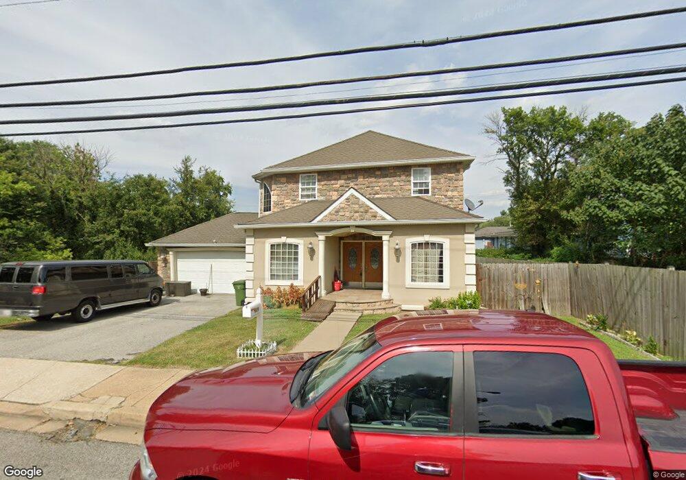
919 Desoto Rd Baltimore, MD 21223
Estimated Value: $315,288 - $350,000
4
Beds
4
Baths
1,624
Sq Ft
$205/Sq Ft
Est. Value
About This Home
This home is located at 919 Desoto Rd, Baltimore, MD 21223 and is currently estimated at $332,644, approximately $204 per square foot. 919 Desoto Rd is a home located in Baltimore City with nearby schools including Violetville Elementary/Middle School, Booker T. Washington Middle School, and Digital Harbor High School.
Ownership History
Date
Name
Owned For
Owner Type
Purchase Details
Closed on
May 5, 2009
Sold by
Wills Rock H
Bought by
Mccutchen Michele
Current Estimated Value
Purchase Details
Closed on
Aug 15, 2005
Sold by
Federal Home Loan Mortgage Corporation
Bought by
Wills Rock H
Purchase Details
Closed on
Jul 18, 2005
Sold by
Federal Home Loan Mortgage Corporation
Bought by
Wills Rock H
Purchase Details
Closed on
Oct 8, 2004
Sold by
Gamble John M
Bought by
Federal Home Loan Mortgage Corporation
Purchase Details
Closed on
Aug 17, 2004
Sold by
Gamble John M
Bought by
Federal Home Loan Mortgage Corporation and Corporation
Create a Home Valuation Report for This Property
The Home Valuation Report is an in-depth analysis detailing your home's value as well as a comparison with similar homes in the area
Purchase History
| Date | Buyer | Sale Price | Title Company |
|---|---|---|---|
| Mccutchen Michele | $245,000 | -- | |
| Wills Rock H | $47,200 | -- | |
| Wills Rock H | $47,200 | -- | |
| Federal Home Loan Mortgage Corporation | $23,000 | -- | |
| Federal Home Loan Mortgage Corporation | $23,000 | -- |
Source: Public Records
Tax History
| Year | Tax Paid | Tax Assessment Tax Assessment Total Assessment is a certain percentage of the fair market value that is determined by local assessors to be the total taxable value of land and additions on the property. | Land | Improvement |
|---|---|---|---|---|
| 2025 | $2,921 | $275,733 | -- | -- |
| 2024 | $2,921 | $254,967 | -- | -- |
| 2023 | $2,917 | $234,200 | $44,200 | $190,000 |
| 2022 | $2,787 | $230,533 | $0 | $0 |
| 2021 | $5,354 | $226,867 | $0 | $0 |
| 2020 | $2,568 | $223,200 | $44,200 | $179,000 |
| 2019 | $2,434 | $222,567 | $0 | $0 |
| 2018 | $2,379 | $221,933 | $0 | $0 |
| 2017 | $2,321 | $221,300 | $0 | $0 |
| 2016 | $2,103 | $217,233 | $0 | $0 |
| 2015 | $2,103 | $213,167 | $0 | $0 |
| 2014 | $2,103 | $209,100 | $0 | $0 |
Source: Public Records
Map
Nearby Homes
- 3101 Wilkens Ave
- 1052 Parksley Ave
- 3024 Strickland St
- 111 S Caton Ave
- 537 S Longwood St
- 2805 Sunset Dr
- 3212 Strickland St
- 510 S Longwood St
- 3021 Stafford St
- 3356 Wilkens Ave
- 3017 Frederick Ave
- 3424 Wilkens Ave
- 2733 Wilkens Ave
- 2822 Frederick Ave
- 2711 Wilkens Ave
- 514 Brunswick St
- 2692 Wilkens Ave
- 2680 Saint Benedict St
- 2684 Dulany St
- 2659 Wilkens Ave
- 921 Desoto Rd
- 923 Desoto Rd
- 925 Desoto Rd
- 911 Desoto Rd
- 930 Wilmington Ave
- 914 Wilmington Ave
- 927 Desoto Rd
- 909 Desoto Rd
- 938 Wilmington Ave
- 912 Wilmington Ave
- 907 Desoto Rd
- 940 Wilmington Ave
- 910 Wilmington Ave
- 1001 Desoto Rd
- 905 Desoto Rd
- 929 Wilmington Ave
- 931 Wilmington Ave
- 927 Wilmington Ave
- 915 Wilmington Ave
- 933 Wilmington Ave
Your Personal Tour Guide
Ask me questions while you tour the home.