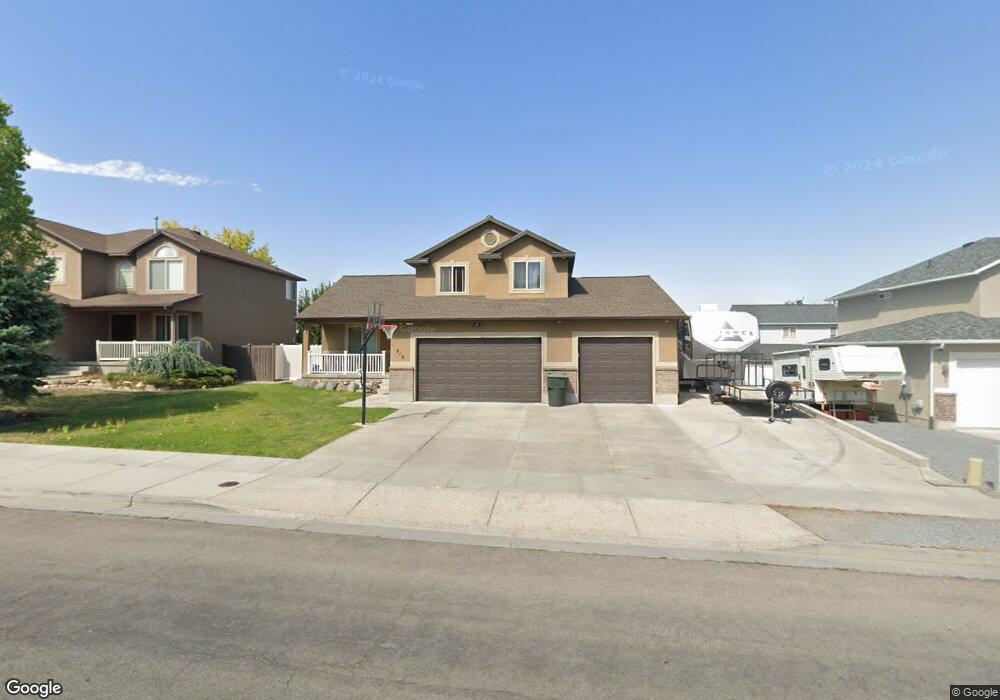
919 Fox Run Dr Tooele, UT 84074
Estimated Value: $462,000 - $489,000
4
Beds
4
Baths
2,517
Sq Ft
$189/Sq Ft
Est. Value
About This Home
This home is located at 919 Fox Run Dr, Tooele, UT 84074 and is currently estimated at $475,115, approximately $188 per square foot. 919 Fox Run Dr is a home located in Tooele County with nearby schools including Middle Canyon Elementary School, Tooele Junior High School, and Tooele High School.
Ownership History
Date
Name
Owned For
Owner Type
Purchase Details
Closed on
Jul 19, 2019
Sold by
May Robert G and May Tamara L
Bought by
Wiedmer Alan J and Wiedmer Louise M
Current Estimated Value
Home Financials for this Owner
Home Financials are based on the most recent Mortgage that was taken out on this home.
Original Mortgage
$299,475
Outstanding Balance
$261,988
Interest Rate
3.75%
Mortgage Type
FHA
Estimated Equity
$213,127
Purchase Details
Closed on
Oct 14, 2009
Sold by
David Kalmar Inc
Bought by
May Robert G and May Tamara L
Home Financials for this Owner
Home Financials are based on the most recent Mortgage that was taken out on this home.
Original Mortgage
$236,646
Interest Rate
5.02%
Mortgage Type
VA
Purchase Details
Closed on
Jan 5, 2005
Sold by
Home Credit Corp
Bought by
David Kalmar Inc
Create a Home Valuation Report for This Property
The Home Valuation Report is an in-depth analysis detailing your home's value as well as a comparison with similar homes in the area
Home Values in the Area
Average Home Value in this Area
Purchase History
| Date | Buyer | Sale Price | Title Company |
|---|---|---|---|
| Wiedmer Alan J | -- | Security Title Ins Agcy Of U | |
| May Robert G | -- | Mountain View Title Insuran | |
| David Kalmar Inc | -- | Merill Title Co |
Source: Public Records
Mortgage History
| Date | Status | Borrower | Loan Amount |
|---|---|---|---|
| Open | Wiedmer Alan J | $299,475 | |
| Previous Owner | May Robert G | $236,646 |
Source: Public Records
Tax History Compared to Growth
Tax History
| Year | Tax Paid | Tax Assessment Tax Assessment Total Assessment is a certain percentage of the fair market value that is determined by local assessors to be the total taxable value of land and additions on the property. | Land | Improvement |
|---|---|---|---|---|
| 2025 | $3,266 | $272,430 | $55,688 | $216,742 |
| 2024 | $3,578 | $273,113 | $55,688 | $217,425 |
| 2023 | $3,578 | $260,185 | $53,036 | $207,149 |
| 2022 | $3,108 | $267,398 | $52,681 | $214,717 |
| 2021 | $2,588 | $186,239 | $21,072 | $165,167 |
| 2020 | $2,455 | $306,442 | $38,313 | $268,129 |
| 2019 | $2,392 | $293,674 | $38,313 | $255,361 |
| 2018 | $2,202 | $256,408 | $40,000 | $216,408 |
| 2017 | $1,842 | $254,488 | $30,000 | $224,488 |
| 2016 | $1,493 | $123,864 | $16,500 | $107,364 |
| 2015 | $1,493 | $108,596 | $0 | $0 |
| 2014 | -- | $108,596 | $0 | $0 |
Source: Public Records
Map
Nearby Homes